

Sport England improves understanding of where investment is needed most with Esri UK’s national data service
14th September 2021
Sport England improves understanding of where investment is needed most with Esri UK’s national data service
1Spatial wins strategic government contract supporting Atkins to deliver NUAR following competitive
13th September 2021
1Spatial wins strategic government contract supporting Atkins to deliver NUAR following competitive
Eos Positioning Systems Becomes Esri Partner Network Gold Partner
31st August 2021
Eos Positioning Systems Becomes Esri Partner Network Gold Partner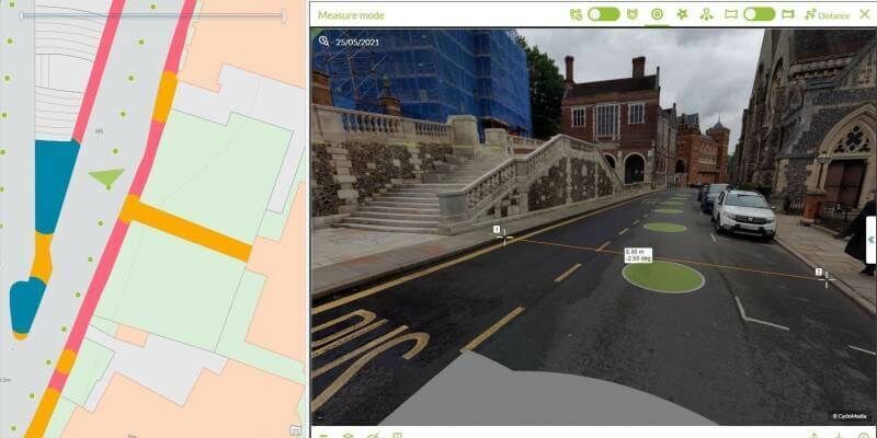
London Borough of Harrow creates digital twin with new street imagery and LiDAR data
26th August 2021
London Borough of Harrow creates digital twin with new street imagery and LiDAR dataWhen remote sensing meets Artificial Intelligence & GIS
20th August 2021
When remote sensing meets Artificial Intelligence & GIS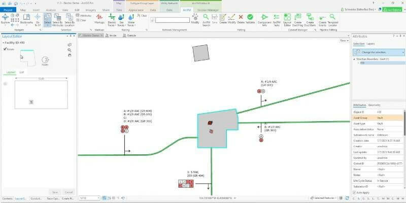
Schneider Electric Releases New Capabilities in Ecostruxure ADMS
20th August 2021
Schneider Electric Releases New Capabilities in Ecostruxure ADMS

RMSI partners with Enzen UK to support Scotia Gas Network (SGN), UK
19th August 2021
RMSI partners with Enzen UK to support Scotia Gas Network (SGN), UKsenseFly Introduces eBee TAC Fixed-wing UAS
19th August 2021
senseFly Introduces eBee TAC Fixed-wing UAS
Schneider Electric Announces New Features for ArcFM Editor XI
19th August 2021
Schneider Electric Announces New Features for ArcFM Editor XI
Gemma Polmear appointed to provide fire service modelling consultancy at Cadcorp
19th August 2021
Gemma Polmear appointed to provide fire service modelling consultancy at CadcorpNorthamptonshire Fire and Rescue Service adopts GIS software for Risk Analysis
19th August 2021
Northamptonshire Fire and Rescue Service adopts GIS software for Risk Analysis
Trimble Expands its Geospatial Automated Monitoring Portfolio
19th August 2021
Trimble Expands its Geospatial Automated Monitoring Portfolio
1Spatial Strengthens Strategic Partnership with Ordnance Survey
19th August 2021
1Spatial Strengthens Strategic Partnership with Ordnance SurveyUCL Virus Watch Study Tracks Location of Volunteers During Covid-19 pandemic
19th August 2021
UCL Virus Watch Study Tracks Location of Volunteers During Covid-19 pandemicDelaware partners with VertiGIS to expand Geospatial Asset Management capabilities
19th August 2021
Delaware partners with VertiGIS to expand Geospatial Asset Management capabilitiesNTIA Creates First Interactive Map to Help Public See the Digital Divide Across the Country
19th August 2021
NTIA Creates First Interactive Map to Help Public See the Digital Divide Across the Country
RMSI partners with Enzen UK to support Scotia Gas Network (SGN), UK for GIS Application Support and Maintenance
4th August 2021
RMSI partners with Enzen UK to support Scotia Gas Network (SGN), UK for GIS Application Support and Maintenance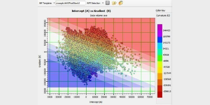
CGG Sells its GeoSoftware Business to Topicus.com and Vela Software
3rd August 2021
CGG Sells its GeoSoftware Business to Topicus.com and Vela Software
Hexagon improves Halberstadtwerke’s utility network management capabilities
28th July 2021
Hexagon improves Halberstadtwerke’s utility network management capabilities
Why A Rules Based Plus A Machine Learning Hybrid Approach
23rd July 2021
Why A Rules Based Plus A Machine Learning Hybrid Approach
Why Location Data Quality Is Important In Policing
22nd July 2021
Why Location Data Quality Is Important In Policing
Schneider Electric Announces New Features for ArcFM Editor XI
21st July 2021
Schneider Electric Announces New Features for ArcFM Editor XI
Esri Releases New Predictive 2050 Global Land Cover Map
16th July 2021
Esri Releases New Predictive 2050 Global Land Cover MapExprodat Meets Industry Challenges with Unconventionals Analyst 2.1 for ArcGIS Pro
6th July 2021
Exprodat Meets Industry Challenges with Unconventionals Analyst 2.1 for ArcGIS Pro

USGIF Announces 2021 Lifetime Achievement Award Recipient
1st July 2021
USGIF Announces 2021 Lifetime Achievement Award Recipient
Extensis Offers GeoViewer Pro All-in-One Geospatial Data Viewer at No Charge
1st July 2021
Extensis Offers GeoViewer Pro All-in-One Geospatial Data Viewer at No Charge
Devon and Somerset Fire and Rescue Service purchase GIS modelling software and services from Cadcorp
1st July 2021
Devon and Somerset Fire and Rescue Service purchase GIS modelling software and services from Cadcorp
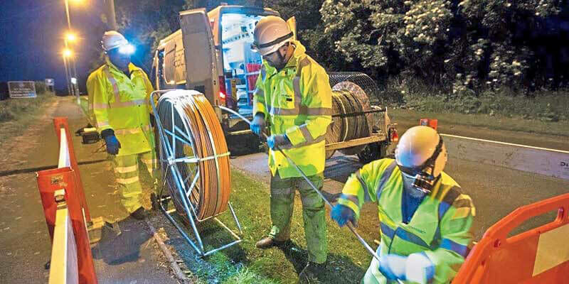
thinkWhere Mapping Portal Helps Scotland Achieve 100 percent Superfast Broadband Coverage
1st July 2021
thinkWhere Mapping Portal Helps Scotland Achieve 100 percent Superfast Broadband Coverage
1Spatial’s flagship conference returns to London for fifth year
30th June 2021
1Spatial’s flagship conference returns to London for fifth year
1Spatial Announced as Esri User Conference 2021 Premium Exhibitor
29th June 2021
1Spatial Announced as Esri User Conference 2021 Premium Exhibitor
Staffordshire Fire and Rescue Service combines GIS with workload modelling and risk analysis
29th June 2021
Staffordshire Fire and Rescue Service combines GIS with workload modelling and risk analysisUCL Virus Watch Study tracks location of volunteers to help understand behaviour during Covid-19 pandemic
29th June 2021
UCL Virus Watch Study tracks location of volunteers to help understand behaviour during Covid-19 pandemicBabergh and Mid Suffolk District Councils move to cloud GIS
22nd June 2021
Babergh and Mid Suffolk District Councils move to cloud GISAsia's one of the biggest geospatial event developed together With the geospatial information industry
22nd June 2021
Asia's one of the biggest geospatial event developed together With the geospatial information industry
Northamptonshire Fire and Rescue Service adopts GIS software for risk analysis
15th June 2021
Northamptonshire Fire and Rescue Service adopts GIS software for risk analysisDelaware partners with VertiGIS to expand Geospatial Asset Management capabilities
14th June 2021
Delaware partners with VertiGIS to expand Geospatial Asset Management capabilities
1Spatial Strengthens Strategic Partnership with Ordnance Survey
10th June 2021
1Spatial Strengthens Strategic Partnership with Ordnance Survey
1Spatial and Version 1 win multiyear contract with Defra
3rd June 2021
1Spatial and Version 1 win multiyear contract with DefraHexagon to host experts, industry leaders at HXGN live resiliency series
28th May 2021
Hexagon to host experts, industry leaders at HXGN live resiliency series
1Spatial unveils new synchronisation functionality to support team-based development and remote collaboration
26th May 2021
1Spatial unveils new synchronisation functionality to support team-based development and remote collaborationUnearth Joins Trimble's GIS Partner Program to Provide Greater GNSS Accuracy and Streamlined Data Collection for Users in Municipal Applications
25th May 2021
Unearth Joins Trimble's GIS Partner Program to Provide Greater GNSS Accuracy and Streamlined Data Collection for Users in Municipal ApplicationsImplementation Service Of A Digital Format Import Solution In The Sigtye System
25th May 2021
Implementation Service Of A Digital Format Import Solution In The Sigtye System