CGG Licenses Geothermal Multi-Client Studies Supporting Energy Transition to US Energy Company
2nd August 2022
CGG Licenses Geothermal Multi-Client Studies Supporting Energy Transition to US Energy Company
2nd August 2022
CGG Licenses Geothermal Multi-Client Studies Supporting Energy Transition to US Energy Company
2nd August 2022
1Spatial enhances survey capabilities in 1Edit28th July 2022
Finding the optimum locations for EV charging stations
25th July 2022
Maxar’s High-Resolution Vivid Basemaps Enhances Esri ArcGIS Living Atlas of the World
20th July 2022
1Spatial Awarded 1integrate Call-Off Contract with Defra
19th July 2022
New International Sales Manager at BARTHAUER
19th July 2022
Winners of Geovation’s Diffuse Coastal Pollution Challenge scoop £5,000 each19th July 2022
Esri UK launches careers resources to inspire more students to study geography and GIS19th July 2022
1Spatial first contract with the state of New York
19th July 2022
Bedfordshire Fire and Rescue Service select Cadcorp GIS for customer insight project
19th July 2022
XMAP cloud GIS joins-up delivery for South Somerset

15th July 2022
Schneider Electric Releases First Edition of Fiber Manager XI and Latest Versions of ArcFM Designer XI and ArcFM Editor XI7th July 2022
Balfour Beatty VINCI adopts new drone software to reduce costs and enhance safety on HS2
1st July 2022
Presagis to Provide Sneak Peek into VELOCITY 5D Digital Twin Production Platform at 2022 Esri User Conference
28th June 2022
Surrey Heath Improves Public Engagement with XMAP Mapping Portal
13th June 2022
New ‘How’ guide demonstrates how geospatial can be applied to climate challenges10th June 2022
Esri UK launches careers resources to inspire more students to study geography and GIS
7th June 2022
Bedfordshire Fire and Rescue Service select Cadcorp GIS for customer insight project
3rd June 2022
Interactive ‘now’ and ‘then’ London map shows how much the city has changed during Her Majesty The Queen’s 70-year reign
31st May 2022
GEO Business 2022 marks huge growth in the geospatial profession
26th May 2022
New Energy Performance Data in XMAP Helps Tackle Climate Change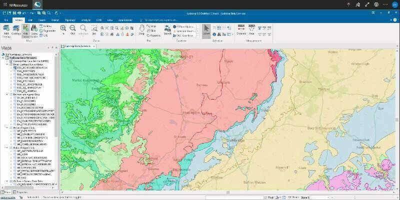
23rd May 2022
1Spatial unveils new Schema transformation capabilities for rules engine
23rd May 2022
1Spatial plc First contract with the State of New York
11th May 2022
Hexagon’s Intergraph G/Technology now available on Oracle Cloud Infrastructure
11th May 2022
1Spatial signs US$1.4m expansion contract with the State of California
9th May 2022
XMAP Helps Mid Sussex Council Protect Amenity Trees2nd May 2022
NOAA showcases new mapping tool for marine species
29th April 2022
Association for Geographic Information Celebrates Return to In Person Events
28th April 2022
USGIF Announces New Scholarships and a New Working Group Focused on Diversity, Inclusion, and Belonging
14th April 2022
Esri UK's annual conference returns to London's QEII Centre after two virtual years
13th April 2022
The key to disaster-resilient grids of the future12th April 2022
TerraGo joins the Esri ArcGIS Marketplace with GeoPDF Publisher for ArcGIS Pro
12th April 2022
XMAP cloud GIS brings government flexible working closer to home12th April 2022
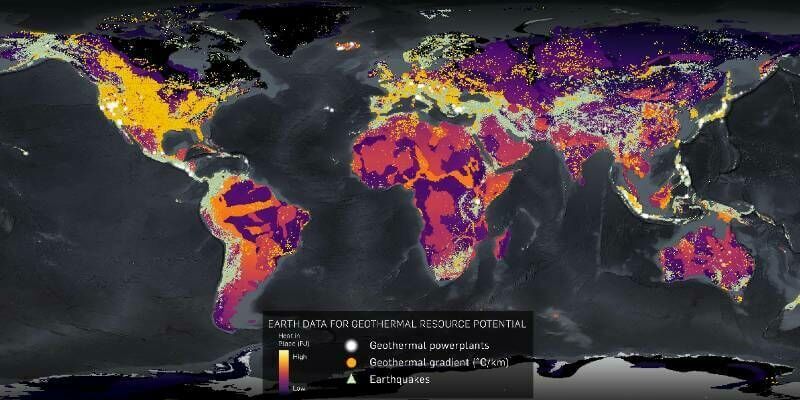
CGG delivers new multi-client study for screening geothermal resources12th April 2022
1Spatial unveils new survey capabilities in 1Edit12th April 2022
Esri releases updated land-cover map with new sets of global data12th April 2022
LAND INFO announces updated 10m USA countrywide land use land cover mapping dataset
12th April 2022
Migration to Cadcorp cloud hosted desktop GIS and web mapping supports social housing provider's digital strategy12th April 2022
Geospatial scholarship fund helps black and mixed black heritage students studying geography at university
7th April 2022
The GEO Business 2022 programme is now live
6th April 2022
New Localisation Options in Improved 1Data Gateway
6th April 2022
Hexagon helps Electricity Company of Ghana modernise electricity distribution
5th April 2022
XMAP Cloud GIS Joins-Up Service Delivery for South Somerset