
Local planning authority projects explore how best to digitise planning process
1st April 2022
Local planning authority projects explore how best to digitise planning process
1st April 2022
Local planning authority projects explore how best to digitise planning process
1st April 2022
Eos Positioning Systems Announces Eos Laser Mapping for Android


15th March 2022
Geospatial Scholarship Fund helps Black and mixed Black heritage students studying geography at university
15th March 2022
Stevenage Borough Council and East Herts District Council ICT Partnership move to Cadcorp corporate GIS in the cloud
14th March 2022
Esri Releases Updated Land-Cover Map with New Sets of Global Data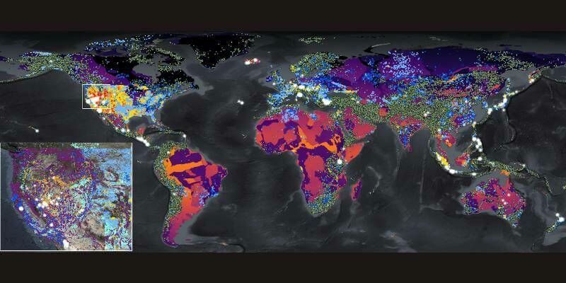
9th March 2022
CGG Delivers New Multi-Client Study for Screening Geothermal Resources
8th March 2022
XMAP GIS Tool Aids UK Government’s £2 Billion Active Travel Schemes
4th March 2022
Cadcorp SIS 9 service release provides additional benefits to users
4th March 2022
GISCI Announces GISCI Endorsement Designation

23rd February 2022
Geo Week 2022 Brings the Geospatial and Built Worlds Together In-Person, Exceeds Expectations
23rd February 2022
Blue Marble Geographics Releases Global Mapper and Global Mapper Pro version 23.1
17th February 2022
TerraGo Joins the Esri ArcGIS Marketplace with GeoPDF Publisher for ArcGIS Pro
16th February 2022
XMAP Cloud GIS Brings Government Flexible Working Closer to Home
16th February 2022
1Spatial Next Generation 911 contract win with State of Montana
14th February 2022
1Spatial Listed in Top 100 Companies in Cambridgeshire League
11th February 2022
1Spatial continues optimising for secure data submission in the cloud
8th February 2022
1Spatial awarded Global Top 100 Geospatial Companies 2022
1st February 2022
Oxfordshire Fire and Rescue Service invests in independently performed Risk Modelling
27th January 2022
1Spatial adds support for GeoPackage and other data formats
25th January 2022
Join us for the 2022 FME World Tour in a city near you!
21st January 2022
1Spatial unveils new survey capabilities in 1Edit

17th December 2021
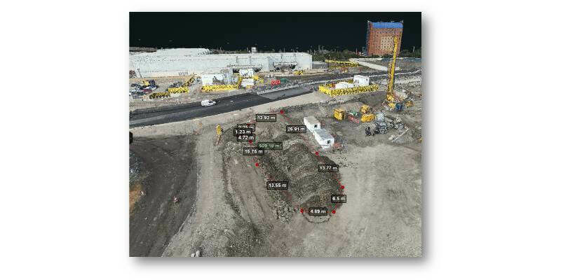
Brent Cross Town £7bn scheme improves workflows with new drone software
9th December 2021
Torus appoints Cadcorp as cloud GIS supplier
8th December 2021
Teign Housing appoints Cadcorp as cloud GIS supplier
8th December 2021
Multi-year contract with Rural Payments Agency
2nd December 2021
IQGeo’s new Network Manager is a game-changer for electric and gas utilities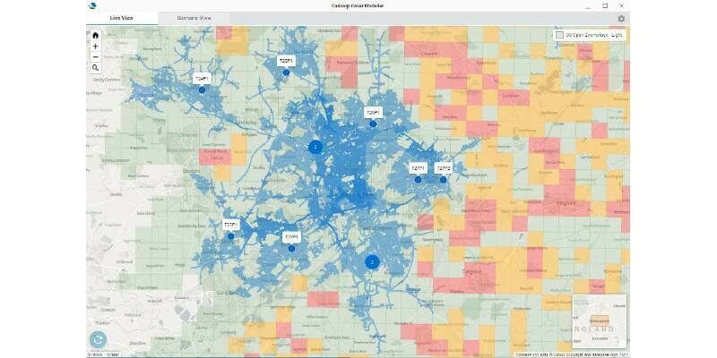
23rd November 2021
Cadcorp launches dynamic cover application for Emergency Services
22nd November 2021
Digital Mapping Shows that Scottish Coastal Erosion will put £1.2 Billion Worth of Assets at Risk
3rd November 2021
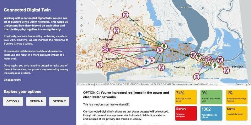
National Digital Twin programme launches interactive app and film at COP26
1st November 2021
Geo Week Award Ceremony Nominations Accepted Until Dec 1
25th October 2021
Staffordshire County Council awards contract to Cadcorp for corporate GIS in the cloud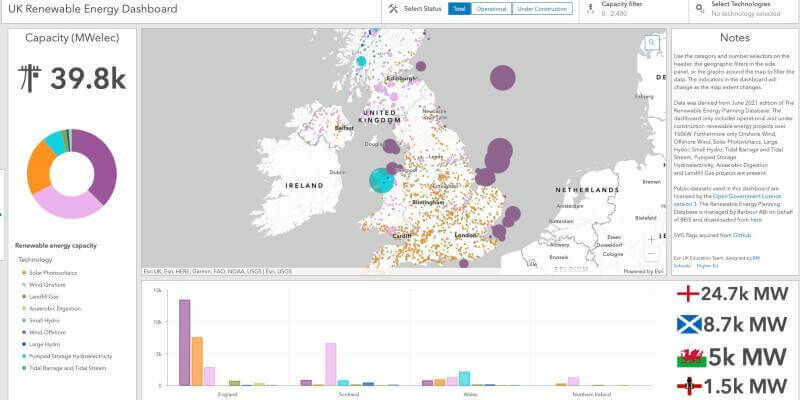
25th October 2021
New teaching resources help children learn about local impact of climate change

18th October 2021
Yunex Traffic and HERE expand partnership to create proactive traffic management solutions
18th October 2021
1Spatial wins strategic government contract supporting Atkins to deliver NUAR following competitive tender
15th October 2021
Arizona Department of Administration (ADOA) selects 1Spatial to support Next Generation 9-1-1 Buildout: GeoCollaboration of ADOA, AZ Department of Transportation and AZ State Land Department
13th October 2021
1Spatial supports major Northern Ireland government digital transformation programme
7th October 2021
We’re excited to announce our agenda and line up of speakers!
7th October 2021
Esri releases ArcGIS GeoBIM, bringing spatial context to AEC operations
4th October 2021
Precisely powers decision-making with critical location-based context in new MapInfo Pro release
1st October 2021
Cadcorp expands fire service modelling expertise
27th September 2021
1Spatial Partnership contract win for UK Government project