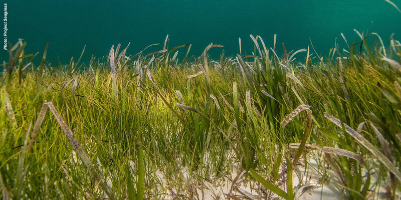
HIPS 800x400

Teledyne CARIS Releases HIPS and SIPS 13 with Modernised User Interface and Multilingual Support

30th April 2026

Teledyne CARIS Releases HIPS and SIPS 13 with Modernised User Interface and Multilingual Support
Research Vessel Cefas Endeavour 800x400

UK scientists unite for seabed mapping survey of the UK’s south-west coastline

19th April 2026

UK scientists unite for seabed mapping survey of the UK’s south-west coastline
Oceanology International 2026 800x400

Record Visitor Numbers and a Rise in Innovation Marks Milestone Year for Oceanology International

18th March 2026

Record Visitor Numbers and a Rise in Innovation Marks Milestone Year for Oceanology International
Oceanology International 2026 800x400

Breakthrough Technology Unveiled at Oceanology International

12th March 2026

Breakthrough Technology Unveiled at Oceanology International
IMG 4737 800x400

First Universal SMART Cable Sensor System Successfully Deployed at Ocean Networks Canada NEPTUNE Observatory

27th February 2026

First Universal SMART Cable Sensor System Successfully Deployed at Ocean Networks Canada NEPTUNE Observatory
Fugros underwater autonomous vehice Seacat 800x400

Mapping Italy’s future: A first-of-its-kind seagrass mapping project to support ocean health and the blue economy

20th January 2026

Mapping Italy’s future: A first-of-its-kind seagrass mapping project to support ocean health and the blue economy
Oceanology 800x400

Oceanology International 2026: The Global Nexus for Ocean Technology

18th December 2025

Oceanology International 2026: The Global Nexus for Ocean Technology
Underwater Li DAR lead THUMBNAIL

Researchers test underwater measuring systems in Indonesian waters

30th October 2025

Researchers test underwater measuring systems in Indonesian waters
Teledyne CARIS UKHO Partnership 800x400

Teledyne CARIS and UK Hydrographic Office Partner to Transform Hydrographic Processing and Nautical Charting

25th July 2025

Teledyne CARIS and UK Hydrographic Office Partner to Transform Hydrographic Processing and Nautical Charting
Sea 5499649 1280 THUMBNAIL

Mapping the ocean faster, smarter, and in real-time

12th July 2025

Mapping the ocean faster, smarter, and in real-time
Galileo HAS lead THUMBNAIL

Galileo delivers High Accuracy Service for Antarctic survey

20th June 2025

Galileo delivers High Accuracy Service for Antarctic survey
25 DG ED 2578 V1 Post Laconia Phase III map 800x400

Viridien and TGS commence Phase III of next-generation Laconia sparse OBN program in US Gulf

20th June 2025

Viridien and TGS commence Phase III of next-generation Laconia sparse OBN program in US Gulf
Advanced navigation june 2025 800x400

Underwater Drone Hydrus Exposes Coral Loss at One of the World’s Southernmost Reefs

6th June 2025

Underwater Drone Hydrus Exposes Coral Loss at One of the World’s Southernmost Reefs
Teledyne Geospatial CZMIL Sea SEC 800x400

Teledyne Geospatial to Participate in SeaSEC Challenge Weeks in the Netherlands

19th May 2025

Teledyne Geospatial to Participate in SeaSEC Challenge Weeks in the Netherlands
Feature Image First All Canadian Antarctic Expedition 800x400

First All-Canadian Antarctic Expedition Draws Underwater Maps with High-Accuracy Using Canadian-Made GNSS Technology

8th May 2025

First All-Canadian Antarctic Expedition Draws Underwater Maps with High-Accuracy Using Canadian-Made GNSS Technology
Riegl may 2025 800x400

Protecting the Unseen: Non-Invasive Seabed and Coral Reef Mapping with RIEGL Aerial Bathymetric LiDAR

1st May 2025

Protecting the Unseen: Non-Invasive Seabed and Coral Reef Mapping with RIEGL Aerial Bathymetric LiDAR
CZMIL Composite 800x400

Teledyne Geospatial's Optech CZMIL SuperNova integral to Tetra Tech's award-winning project

3rd March 2025

Teledyne Geospatial's Optech CZMIL SuperNova integral to Tetra Tech's award-winning project
Steve Jones Celestia CEO 800x400

Celestia Reports Strong Performance & Growth In 2024

25th February 2025

Celestia Reports Strong Performance & Growth In 2024
T Carta Negril Graphic 800x400

TCarta Announces Satellite Derived Bathymetry Product to Supplement Official Nautical Charts in Shallow Coastal Zones

21st February 2025

TCarta Announces Satellite Derived Bathymetry Product to Supplement Official Nautical Charts in Shallow Coastal Zones
1200id View1 800x400

Tritech Announces Launch of New Gemini 1200id

3rd February 2025

Tritech Announces Launch of New Gemini 1200id
Fugro jan2025 800x400

Fugro leads large-scale seafloor mapping project to protect Florida’s coast

8th January 2025

Fugro leads large-scale seafloor mapping project to protect Florida’s coast
Steve Steele STR 800x400

STR gears up for growth after investment deal with Star Capital

11th December 2024

STR gears up for growth after investment deal with Star Capital
Teledyne Geospatial Fathom 800x400

Teledyne Geospatial to present an exclusive preview of its new coastal mapping solution at HYDRO 2024

31st October 2024

Teledyne Geospatial to present an exclusive preview of its new coastal mapping solution at HYDRO 2024
24 DG ED 1805 V1 Post Bonaparte Oct Web 800x400

Viridien and SLB complete the data acquisition for a multi-client survey in Bonaparte Basin, offshore Australia

25th October 2024

Viridien and SLB complete the data acquisition for a multi-client survey in Bonaparte Basin, offshore Australia
Fugro Discovery 800x400

Fugro extends role in Norway’s 2024 MAREANO programme for seabed mapping with eDNA service

4th October 2024

Fugro extends role in Norway’s 2024 MAREANO programme for seabed mapping with eDNA service
02 Sanna 800x400

Cube4EnvSec Linking Ship Sensors into Federation

5th June 2024

Cube4EnvSec Linking Ship Sensors into Federation
T Geospatial DEM Lake Superior 800x400

Tetra Tech purchases Teledyne’s CZMIL SuperNova to successfully complete NOAA's Great Lakes Coastal Mapping project

13th March 2024

Tetra Tech purchases Teledyne’s CZMIL SuperNova to successfully complete NOAA's Great Lakes Coastal Mapping project
Fugro australia 800x400

Fugro’s ROV Induction course is coming to Australia

8th March 2024

Fugro’s ROV Induction course is coming to Australia
Teledyne oceanology 800x400

Teledyne Geospatial to bring new Optech hardware and CARIS software solutions to Oceanology International 2024

1st March 2024

Teledyne Geospatial to bring new Optech hardware and CARIS software solutions to Oceanology International 2024
Bathy feature 800x400

Reaching New Depths: New RIEGL Laser Scanning Solutions for Bathymetric Data Acquisition

23rd February 2024

Reaching New Depths: New RIEGL Laser Scanning Solutions for Bathymetric Data Acquisition
Port Antonio 800x400

TCarta Plans Bathymetric Mapping Workshop for Jamaica with Seabed 2030 Funding

6th February 2024

TCarta Plans Bathymetric Mapping Workshop for Jamaica with Seabed 2030 Funding
Navigator 800x400

Introducing the YellowScan Navigator: a groundbreaking bathymetric LiDAR System dedicated to coastal and river mapping from drones

17th January 2024

Introducing the YellowScan Navigator: a groundbreaking bathymetric LiDAR System dedicated to coastal and river mapping from drones
Nortek bøye 800x400

Ferd invests in ocean technology group General Oceans

21st December 2023

Ferd invests in ocean technology group General Oceans
TDI Brooks High Res Seismic 800x400

TDI-Brooks Completes 2D High Resolution Seismic Program Off Trinidad

12th December 2023

TDI-Brooks Completes 2D High Resolution Seismic Program Off Trinidad
Fugro Florida 800x400 1

Fugro supports coastal resilience in Florida with new seafloor mapping contract

25th September 2023

Fugro supports coastal resilience in Florida with new seafloor mapping contract
Earth 800x400

TCarta to Deliver Satellite Derived Bathymetry for 13 Regions to National Geospatial-Intelligence Agency

15th June 2023

TCarta to Deliver Satellite Derived Bathymetry for 13 Regions to National Geospatial-Intelligence Agency
Ocean Business Day 1 7 800x400

Ocean Business 2023 back with a bang!

28th April 2023

Ocean Business 2023 back with a bang!
Int v22 i1 T Carta Expands Role in Seabed 800x400px

TCarta Expands Role in Seabed 2030 Ocean Survey Project

14th April 2023

TCarta Expands Role in Seabed 2030 Ocean Survey Project
4 V5 A9483 800x400

The countdown to next week’s Ocean Business 2023 is on!

12th April 2023

The countdown to next week’s Ocean Business 2023 is on!
7 R6 C9733 800x400

Ocean Business 2023 conference programme announced

23rd March 2023

Ocean Business 2023 conference programme announced
DSC 0147 800x400

GSSI Highlights 200 HS Antenna for Applications Requiring Deeper Penetration Depths

7th March 2023

GSSI Highlights 200 HS Antenna for Applications Requiring Deeper Penetration Depths
Leica Hawk Eye 5 Image 800x400 1

Leica Geosystems announces performance upgrades for airborne deep bathymetric surveys

14th February 2023

Leica Geosystems announces performance upgrades for airborne deep bathymetric surveys
FET Visual DVR 800x400 1

Forum Unveils All New VisualDVR System

6th February 2023

Forum Unveils All New VisualDVR System
Topodrone 800x400 1

TOPODRONE synchronized LiDAR and bathymetric surveying methods to study a floating solar farm in Israel

16th January 2023

TOPODRONE synchronized LiDAR and bathymetric surveying methods to study a floating solar farm in Israel
Gondola2 800x400 1

TDI-Brooks Upgrades Deepwater Multibeam To Em304 MKI

13th December 2022

TDI-Brooks Upgrades Deepwater Multibeam To Em304 MKI
Coastal Concerns thumbnail

Coastal concerns: how data can help us understand the pressure of climate change

7th December 2022

Coastal concerns: how data can help us understand the pressure of climate change
Int V21i03 17 Asian fugro maritime papua

Fugro and National Maritime Safety Authority improve Papua New Guinea’s navigation safety

2nd November 2022

Fugro and National Maritime Safety Authority improve Papua New Guinea’s navigation safety
Ukho provides 800x400 1

UKHO provides bathymetric surveys for the Seabed 2030 project

6th October 2022

UKHO provides bathymetric surveys for the Seabed 2030 project