
Using ‘imaginative’ AI to survey past and future earthquake damage
26th March 2026
Using ‘imaginative’ AI to survey past and future earthquake damage
26th March 2026
Using ‘imaginative’ AI to survey past and future earthquake damage
28th November 2025
Hexagon launches GeoMonitoring, a web platform for safety monitoring
15th April 2025
Bentley for Government Software Now Listed on FedRAMP Marketplace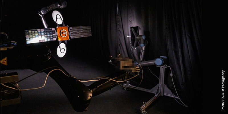
28th January 2025
Vision-based navigation system enables satellites to approach or avoid other objects in space
10th September 2024
Bentley Systems Acquires 3D Geospatial Company Cesium


14th April 2023
Leica Geosystems announces 3D machine control compatibility options for Caterpillar NGH excavators
15th March 2023
Leica Geosystems announces 3D machine control compatibility options for Caterpillar NGH excavators

2nd February 2023
Digital revolution inspires new research direction in ecosystem structural diversity
7th December 2022
Hexagon, OSASI partner for disaster management and prediction solutions

12th April 2022
Bentley Systems wins Company of the Year at 2021 Construction Computing Awards
12th April 2022
Survtech using simactive software for energy infrastructure projects
7th March 2022
3D PluraView – stereoscopic 3D-visualisation for the oil- and gas industry
4th March 2022
SurvTech Using SimActive Software for Energy Infrastructure Projects
5th November 2021
Phase One - P3 Payload Power Line Inspection Test Flight
5th November 2021
Phase One - P3 Payload Bridge Inspection Test Flight
5th November 2021
Phase One - P3 Payload Cellphone Tower Inspection Flight
1st July 2021
New tech from Maptek to uncork geology bottleneck
10th June 2021
Golden Software Enhances Grapher Package with Faster Run Times and Improved Functionality Across Plot Types

28th April 2021
Campfire Emerges From Stealth With Unique Holographic Collaboration System for Professional 3D Design Workflows
6th April 2021
Call for papers and open registration announcement
23rd March 2021
RIEGL Announces NEW Products in the ALS and MLS Sector

2nd March 2021
Leica BLK247 Smart 3D Surveillance System now available in two versions
24th February 2021
Redefining affordable high-quality drone LiDAR/Imagery sensors
18th January 2021
Real estate management during the COVID pandemic - Webinar
17th January 2021
OGC seeks public comment on proposal to revise Indexed 3D Scene Layers (I3S) Community Standard

2nd December 2020
The 3D PluraView stereo monitor family – Meeting the highest requirements for Geospatial applications
29th October 2020
Schneider Digital’s 3D PluraView stereo monitor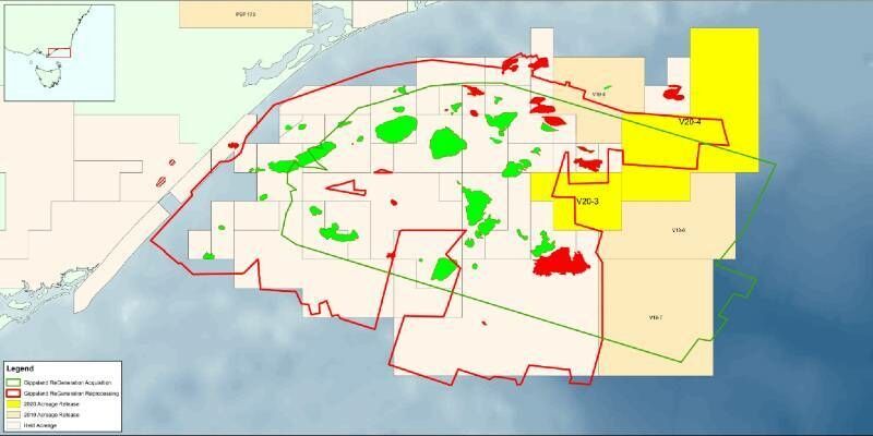
23rd September 2020
CGG’s Fast-Track Data from Basin-Wide Gippsland 3D Survey Supports Australia’s Acreage Release
17th September 2020
3D PluraView - The Global Reference for Passive 3D-Stereo Monitors in all Geospatial Applications

17th September 2020
Pix4D and SAP start a joint innovation project for the 3D inspection of transmission masts
11th September 2020
Support for 3D Vision Pro canceled by NVIDIA! The alternative by Schneider Digital is the 3D PluraView stereo monitor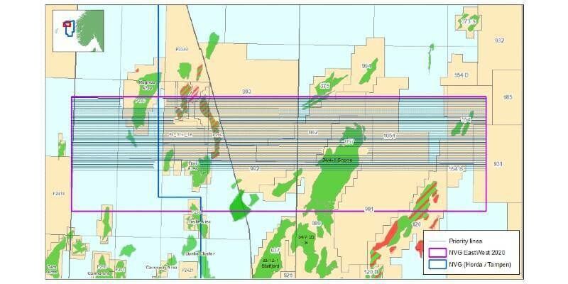
28th August 2020
CGG Adds Second Azimuth to Northern Viking Graben Multi-Client Survey

18th August 2020
Managing authoritative data in both 2D and 3D at 3DGeoInfo 2020 conference
2nd July 2020
CGG GeoSoftware and Alibaba Cloud Collaborate to Support the E&P Industry with Cloud Geoscience Technologies