Share
Esri UK announced a new set of free teaching resources, designed in collaboration with the Met Office to help children aged 7-16 learn about climate change and its impact on their local area.
By combining the Met Office’s climate change expertise and latest projections, with Esri UK’s interactive maps and dashboards, the online materials focus on how climate change will impact our daily lives over the next 50 to 100 years.
Esri UK’s Education team has created the resources with help from the Met Office Education department to ensure the industry’s latest authoritative research and understanding has been applied. Aimed at geography teachers in key stage 2, 3 and 4, the three different resource packs examine weather, climate and how climate change will affect key areas of everyday life, including transport, agriculture, health and energy. Due to their interactive nature, the resources help make lessons investigative and personalised so students can explore climate change at both national and local levels.
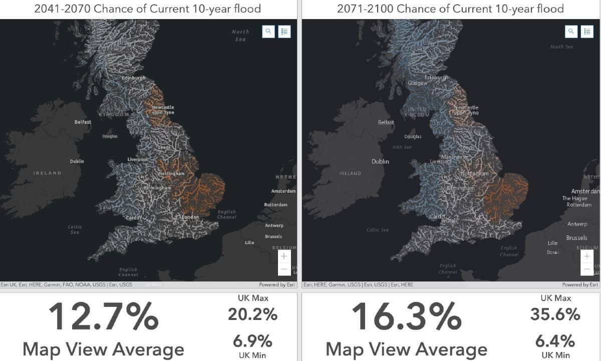
The Met Office’s projections from July 2021, UK Climate Projections, have been used in maps and dashboards, which make complex analysis accessible and teachable. Example resources include side-by-side comparisons of climate now and in the future, making it easier for students to see changes in temperature or rainfall, for example. Other teaching aids examine the chance of future heatwaves, droughts, major floods and wildfires across the UK and help learners explore numerous impacts, including:
*How many days will trains be disrupted when rail lines are at risk from heat buckling?
*How many days will you need air conditioning in London or even Aberdeen, by the year 2100?
*What is the chance of a significant drought impacting crops and livestock in the next 50 years?
*How likely are summer flood events that can quickly flood our city streets?
Professor Jason Lowe, head of climate services at the Met Office, commented: “Climate change is happening, and it will increasingly impact the way we live in the UK over the next century. Ensuring teachers have good resources to teach children about the science and impacts of climate change is important as it will help them prepare for, and adapt to, these changes.”
“Climate change is centre stage as the UK hosts COP26 in Glasgow this November so we wanted to develop resources to help children understand that climate change is happening on their doorstep, not just in the polar regions or rain forests around the world,” explained Stuart Bonthrone, chief executive of Esri UK. “By making climate change highly relevant and showing that it will happen in a student’s local area, it helps teachers prepare younger generations for the challenges which lay ahead.”
Kit Rackley, climate science communicator at the University of East Anglia, former teacher and member of the Geographical Association’s community of geography educators, said: “As a science communicator with experience both as a high-school Geography teacher and education officer for climate scientists, I am very impressed with the resources. It’s very challenging to communicate rich and robust climate data in a way that is accessible and engaging. The ‘story map’ approach allows students and teachers to navigate the data and explore it to a degree which allows them to see how climate change is impacting their lives in a multitude of ways.”
The new resources are available here as part of Esri UK’s free schools programme.
Subscribe to our newsletter
Stay updated on the latest technology, innovation product arrivals and exciting offers to your inbox.
Newsletter

