
Presagis Introduces VELOCITY 5D Plugin for Unreal Engine
1st February 2023
Presagis Introduces VELOCITY 5D Plugin for Unreal EngineThe creation, visualisation and use of three-dimensional representations of real or virtual world terrains, surfaces, elevations and built objects
Three-dimensional models are used increasingly in the public and private sectors and in academic research to visualise and analyse real or virtual world features and objects. This topic encompasses the creation of 3D geometric models from captured spatial data and their use in applications that include architecture, construction, engineering, urban planning, city and infrastructure modelling, transport and utility network planning and management, asset management, entertainment film production, video gaming and the geosciences. Additionally, the topic covers the creation and use of 3D models that make use of Virtual, Augmented and Mixed Reality techniques
1st February 2023
Presagis Introduces VELOCITY 5D Plugin for Unreal Engine20th January 2023
Intermap Announces New Flood Modeling Initiative in Thailand4th January 2023
BAAM.Tech Named North American Software Distributor and Technical Support Partner for Terrasolid
29th December 2022
Vodafone’s mobile network has a digital twin22nd December 2022
Hexagon adds speed, scalability and automation to digital twin creation with the acquisition of LocLab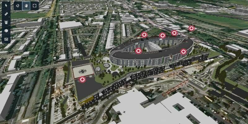
19th December 2022
Evercam’s new 4D View, powered by iTwin, improves collaboration with easier access to real-time videos and project design data15th December 2022
Vodafone’s mobile network has a digital twin
7th December 2022
Coastal concerns: how data can help us understand the pressure of climate change
6th December 2022
Immersal launches AR game arcade solution1st December 2022
Digital Integrator Cohesive Group Acquires Vetasi, Provider of IBM Maximo Managed Services30th November 2022
iNESS Data Twins of Commercial Spaces Powered by Bentley iTwin
29th November 2022
Hexagon and Fujitsu support Stuttgart’s urban digital twin project
29th November 2022
RiPROCESS version 1.9.3 is available now
17th November 2022
Riegl Lidar Used In Award Winning Digital Twin Project At YVR Airport
16th November 2022
Presagis Launches Cloud-Based VELOCITY 5D Digital Twin Production Platform11th November 2022
Bentley Systems Enhances SYNCHRO Construction Management Solution with New Capabilities and Applications10th November 2022
FARO Zone 3D Forensic Scene Analysis Software Delivers New Photogrammetry Capabilities8th November 2022
Bentley Systems Announces Integration of EC3 with the Bentley iTwin Platform for Infrastructure Carbon Calculation
2nd November 2022
New scanning and imaging solution from Trimble simplifies 3D deliverables2nd November 2022
Fukui computer partners with Bentley Systems to promote digital transformation in Japan’s infrastructure field2nd November 2022
HEAVY.AI launches industry’s first digital twin for telco network planning, building and operations, leveraging the NVIDIA Omniverse platform2nd November 2022
Akular Twin achieves powered by iTwin designation2nd November 2022
Creaform releases tenth version of their VXelements 3D measurement software platform2nd November 2022
Presagis extends 3D tiles next workflow into Esri ArcGIS Pro21st October 2022
Hexagon and LocLab announce strategic partnership to accelerate the adoption of Smart Digital Realities in transportation, construction and urban planning
20th October 2022
Geo Week Announces Media Support for 2023 Event
17th October 2022
Intergeo 2022: The Power Of The 'Digital Twins' 3D Models Make The World Smarter21st September 2022
HEAVY.AI Launches Industry’s First Digital Twin for Telco Network Planning, Building and Operations, Leveraging the NVIDIA Omniverse Platform15th September 2022
Golden Software Enhances Grid Displays and Data Coordinate Conversion in Latest Surfer Surface Mapping Package14th September 2022
Bentley Systems to Host iTwin Developer Conference, Building Software for a Better World, Sept. 208th September 2022
LiDAR and Digital Surface Models from Bluesky Aid Wind Farm Planning7th September 2022
Bentley Systems Announces Michael Campbell Joining as Chief Product Officer
31st August 2022
3D Stereo visualization with 3D PluraView improves Hexagon ImageStation photogrammetry workflow22nd August 2022
USGIF Announces 2022 Scholarship Award Winners
22nd August 2022
Public Comment Requested on revision to OGC 3D streaming community standard, I3S19th August 2022
AKULAR TWIN achieves Powered by iTwin designation
16th August 2022
Bluesky Wins Extension to Multi Million Pound UK Government Mapping Contract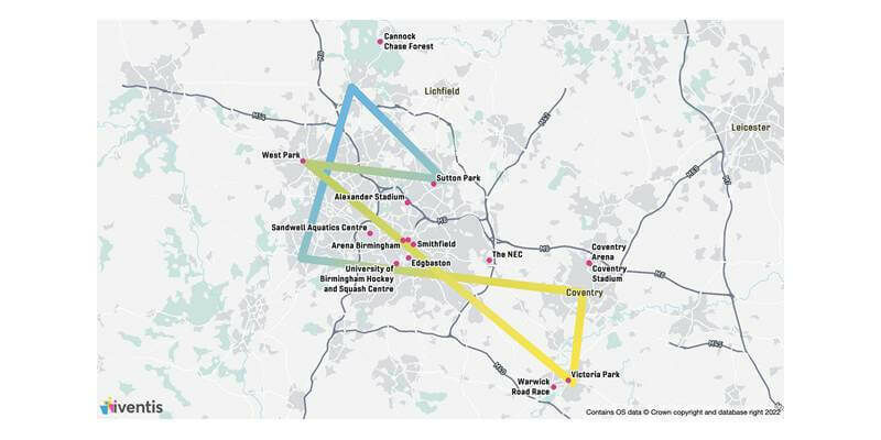
26th July 2022
Birmingham 2022 Commonwealth Games selects Iventis as official technology supplier
21st July 2022
Managing More than 80,000 Miles of Roads, Texas DOT Implements a Digital Delivery Initiative for New Bridge Projects
21st July 2022
RIEGL VZ-400i BEAMS a New Light on Temperate Forest Carbon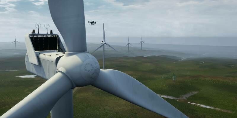
20th July 2022
Microsoft launches Project AirSim, an end-to-end platform to accelerate autonomous flight19th July 2022
Hexagon disrupts reality capture once again with its next-generation, ultra-fast Leica BLK360 laser scanner19th July 2022
Clirio launches world's first end-to-end holographic scan and review apps19th July 2022
CGG joins Norway's Centre for Geophysical Forecasting19th July 2022
RIEGL USA continues to provide mobile LiDAR solutions to WGI