Share
An Irish hydrological consultancy firm is saving significant time and expense by using LiDAR datasets from Bluesky International, the aerial survey and mapping company.
Hydro-Environmental Services (HES) carries out essential analysis for public and private clients to determine optimal layouts (from a drainage and environmental impact perspective) for wind farm sites that are often planned in remote upland forested areas.
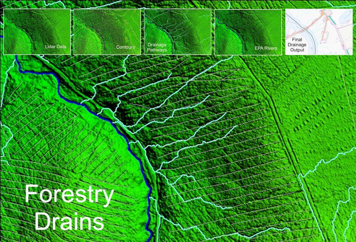
Mapping prevailing drainage patterns is a key part of the assessment stage in addition to ensuring that existing areas of environmental importance, like peatlands which store carbon, are not significantly disturbed. Michael Gill is a Director at HES and he explains: “To analyse the drainage patterns for proposed wind farm sites we need a clear picture of where the existing streams and drainage channels are located. Available national river mapping only goes so far in providing the information we need, so for a more detailed site-specific picture of current drainage patterns we are now using LiDAR imagery from Bluesky.
The LiDAR data means we can generate a comprehensive and accurate definition of site drainage in advance of site surveys when ground-truthing and environmental monitoring are undertaken. Importantly, the enhanced drainage definition we can extract from the LiDAR data is used in our constraints studies to identify areas of proposed sites that are not suitable for development.”
HES is using Bluesky’s Digital Terrain Models (DTM) specifically to analyse areas under tree canopies to assess what is happening in terms of forestry drainage. Mr Gill added: “Using the DTM data we can digitise forestry drainage to supplement and enhance our drainage mapping datasets. We can then export the enhanced drainage mapping to engineering drawings and integrate into proposed drainage plans for wind farm site planning applications. Without these data, we would have to physically survey the under-tree canopy areas and this would prove near impossible given the scale and topography of many of the sites.”
“The data enables us to provide our clients with the information they need in an efficient manner as we can turn all of this information around in several hours from our desks instead of carrying out time consuming and expensive site walkover surveys. The Bluesky Mapshop is of huge benefit to us as we can download the data we need in minutes and high-level decisions can be made quickly and early in the project lifecycle.”
Mr Gill also added: “HES also uses Bluesky Lidar data in many other aspects of our work, including flood risk assessments, quarry planning applications, and ecohydrological studies. We find new ways to use Bluesky Lidar data every day in all aspects of our project work. The uses are endless.”
Robert Loughran, Bluesky’s International Sales Manager (Ireland), added: “The use of our products to advise suitable wind farm locations is just one of the many ways geospatial data can be used to support environmental and carbon reduction initiatives and plans. The fight against climate change is an important one that needs properly informed decisions. Data is and will continue to play a key role in supporting public and private initiatives ensuring plans and recommendations can be made confidently knowing accurate analysis has driven them.”
Subscribe to our newsletter
Stay updated on the latest technology, innovation product arrivals and exciting offers to your inbox.
Newsletter

