Share
Seppe Cassettari argues that by learning and applying lessons from the past, we can help future generations avoid the need to re-invent the wheel
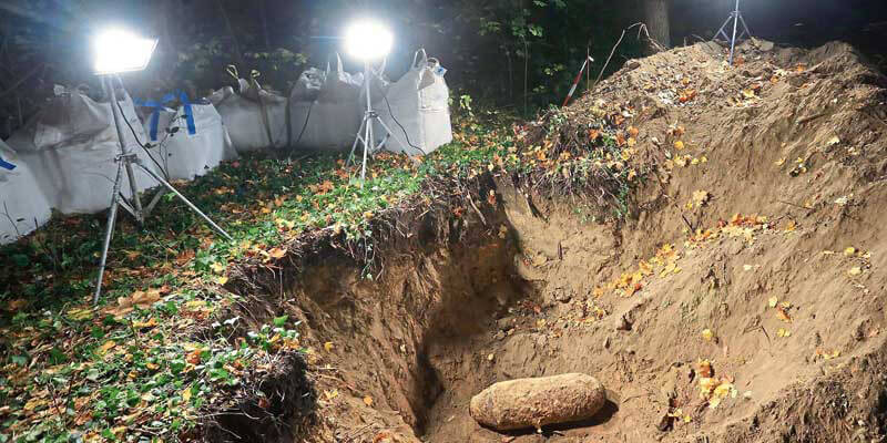
During WWII, some three million tonnes of ordnance were dropped on targets in the UK and mainland Europe. Best estimates are that one in six bombs, shells and missiles failed to explode, with some 7,500 remaining undiscovered in Britain alone. These are known as EROW or Explosive Remnants of War.
The problem is worse in mainland Europe with, perhaps, half a million munitions of all types still to be found. If you add in those that are constantly being dug up on the battlefields of the First World War, it’s a huge, if little-known problem, with ageing fuse mechanisms adding to the chance of a spontaneous explosion.
Delay and disruption
The impact of unexpectedly unearthing a bomb or shell can be huge. It can bring construction work to a standstill and take days to defuse and remove. Local residents often have to be evacuated and the ensuing delay and disruption is always costly. Chris Going, Senior Analyst at The GeoInformation Group, a Verisk Analytics business, recently estimated the cost of a single incident at between €140,000 and 200,000.
One of the real issues is that many munitions were dropped far from their targets and whose whereabouts were unknown. As those in charge of planning RAF raids could not rely on post-event images captured by Photo Reconnaissance Units (PRUs), cameras were installed in the bombers themselves. These captured imagery over the drop zone to help assess where the munitions went. With most RAF raids being conducted at night, plots of light points were made post-raid to support the analysis.
A recent project (the Bomber Command Database or BCD project) has unearthed a collection of these plots and is turning them into a GIS database to identify areas where EROW may still exist in Germany. Given that nearly 7,000 raids were conducted by the RAF on German targets, there are probably thousands of plots, filed away in the National Archives at Kew or elsewhere.
Who would have thought that these plots would still have anything other than historical value 65 years after the event? And this is the point: we can’t predict when or how information may be of use in the future. In the example given, it has a real health and safety implication, not to mention huge economic value. It surely makes the case for a more systematic collection of the voluminous data we currently collect.
While we have laws that require published material to be lodged with one of the five national copyright libraries, many GIS databases and the maps generated from them are ephemeral in nature and are never preserved for a future generation to access.
A great idea at the time
I remember back in the 1990s there was a big push to have data providers/publishers collect metadata about their databases and maps. The requirements were somewhat demanding and placed a significant overhead on those that signed up. It inevitably fell by the wayside, being an initiative that seemed a great idea at the time, but lacked immediate relevance (and here I apologise to those who are still keeping the faith and adding metadata to everything they publish).
The same is true of archiving. There have been initiatives to ensure that copies of key databases or digital maps are lodged with the national archives, but problems of storage and access meant that little was achieved in any systematic or comprehensive way.
If you accept that the past is often a window onto the future, by not archiving GIS databases and the tremendous maps and analyses they offer, we lose a perspective from our time that might inform and support future needs. It would be a shame if, for lack of a considered approach to archiving, we condemn future generations to re-invent much of what we have laboured so hard to create.
Dr. Seppe Cassettari is a GIS professional, with more than 25 years’ experience in developing and applying geospatial technologies in the public, private and educational sectors. He was most recently CEO of The Geoinformation Group (now Verisk’s Geomni UK business)


