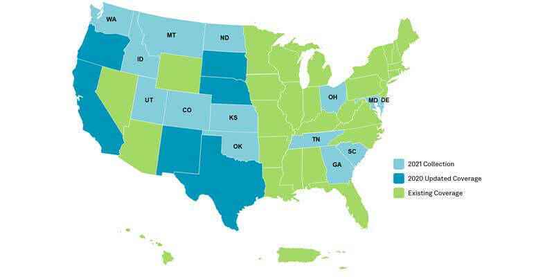
HxGN Content Program to collect new single-season aerial data of 14 U.S. states this year
1st July 2021
HxGN Content Program to collect new single-season aerial data of 14 U.S. states this year
1st July 2021
HxGN Content Program to collect new single-season aerial data of 14 U.S. states this year
1st July 2021
Introducing NavVis IVION Core, a reality capture platform that adds more value to buildings and assets

14th June 2021
Spectra Geospatial Introduces Next Generation of Field Solutions for Survey Professionals
4th June 2021
Trimble Expands its Geospatial Automated Monitoring Portfolio with Worldsensing Geotechnical IoT Solutions
1st June 2021
Virtual Surveyor Introduces Enhanced Stockpile Reporting in Drone Surveying Software
27th May 2021
Fugro wins Network Rail contract to deliver gauging survey and ‘digital twin’ of Scotland’s Railway
18th May 2021
Vaisala and Yotta join forces to help UK councils make faster and smarter use of road condition data
13th May 2021
Mining in Latin America: Overview and Projections 2021
10th May 2021
Terra Drone Has Completed 1000+ LiDAR Survey Projects Globally in 2020
10th May 2021
TCarta Delivers Satellite-Derived Bathymetry to NOAA for U.S. Coastal Mapping Pilot


5th May 2021
Introducing: P3 Payload - Unmatched inspection productivity and versatility
29th April 2021
Topcon Lined Up as Expert Partner for Digital Skills Initiative

29th April 2021
Trimble Announces Rugged, Lightweight Field Data Controller for Land and Construction Surveying
29th April 2021
New Sokkia total stations designed as part of full, productive workflow solution
29th April 2021
Garmin announces GWX 8000 StormOptix weather radar with automated weather threat analysis technology
29th April 2021
CGG Delivers 9,300 sq km of Data from Agata Reimaging to Support Brazil’s 7th Bidding Round
26th April 2021
Riegl Ricast: Scan And Deliver – The New Vux-120
15th April 2021
Discover how the SP85 GNSS receiver is used in the field
14th April 2021
Trimble T100 Tablet Delivers High-Performance Computing in the Field
13th April 2021
SocietyWorks partners with Yotta to help UK councils get residents’ issues resolved faster
31st March 2021
GeoSLAM launches next generation data processing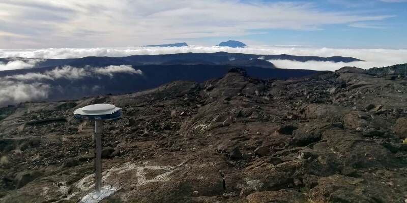
25th March 2021
Active Volcano Monitored with Spectra Geospatial SP85 GNSS Receivers
24th March 2021
Phase One Announces P3 Drone Payload for Asset Inspection
24th March 2021
Piaggio Fast Forward and Trimble Announce Proof–of-Concept Collaboration to Utilize Proprietary Smart Following Technology
23rd March 2021
RIEGL Announces NEW Products in the ALS and MLS Sector

9th March 2021
M&E Deploys Advanced Survey System for Aggregate Mining
4th March 2021
UKHO launches new innovation challenge to reduce the impact of coastal inundation
3rd March 2021
Trimble Announces Rugged, Lightweight Field Data Controller for Land and Construction Surveying
2nd March 2021
First aerial drone-dipping sensors take off with Valeport
2nd March 2021
Emlid Released ReachView 3: Native App for Reach Receivers
2nd March 2021
Juniper Systems Limited Announces Customisation Programme for Ultra-Rugged Handheld Computers
2nd March 2021
JLT Mobile Computers adds new 10” tablet to its field-proven range of rugged Windows devices for workers on the move
2nd March 2021
MARSS Appoints Andrew Forbes to Lead New Arabian Office
2nd March 2021
GSSI Announces Distribution Agreement with InstroTek on PaveScan RDM Continuous Asphalt Density Gauge
2nd March 2021
Cyprus Subsea and Subsea Europe Services collaborate to create combined Hydrography and Oceanography portfolio
2nd March 2021
Leica BLK247 Smart 3D Surveillance System now available in two versions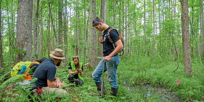
1st March 2021
Ecobot joins Trimble’s GIS Partner Program to empower environmental regulatory reporting
26th February 2021
Leica Geosystems Offers Mobile, Agile 3D Reality Capture Solution for Boston Dynamics Spot
15th February 2021
Ordnance Survey and UK PropTech Association announce partnership to drive digital transformation in the property industry
12th February 2021
Juniper Systems Limited Announces Customisation Programme for Ultra-Rugged Handheld Computers
1st February 2021
Latest Job from KOREC GROUP - Service Technician
1st February 2021
Latest Job from KOREC GROUP - Senior Applications Engin
1st February 2021
Latest Job: Geospatial Sales Consultant Midlands