Share
The surveyors at Denmark’s largest provider of surveying and land management services disrupted their own field by inventing a measurement app that anyone with a smartphone can use. Thea Jessen Kristensen explains why
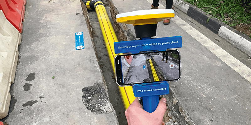
We believe we have disrupted the way subsurface utility mapping is done. Our app, SmartSurvey, converts a simple video acquired on a standard smartphone into a complex 3D point cloud, while our web-based solution, PointView, is a user-friendly tool that provides access through a browser to the massive amounts of data that SmartSurvey creates.
Our pilot tests are over and our two new technologies are up and running. So far, they have been used to collect 3D reality captures of more than 7,000 utilities excavations.
So now, staff at utilities and construction companies can now collect survey data themselves – there’s no need to wait for a land surveyor when everyone who has a mobile phone can be a surveyor themselves. So how did we get to this point, given we’re a traditional surveying company? Were we looking to put ourselves out of work?
How it started
Water Partner is an innovative partnership centred around Aarhus Water, the utility company in Aarhus, Denmark. At Water Partner, 13 different companies comes together to innovate, change and revolutionise the utility sector together.
Our partnership with Water Partner began in 2017 and came at a time when we had set out on a new direction as the largest surveying consultancy in Denmark. Our ambition was to become the leading company in our field by developing innovative solutions that unfold the potential of current technology pushes. We even established an IT department, IT34.
It was at a Water Partner workshop that SmartSurvey was conceived.
“I talked to LE34 about the challenges we face,” says Peter Hjortdal, head of department for construction projects at Aarhus Water. “One of them was that the time from when something was done in the field until the data was received and loaded in our grid registration was too long. Together, we made a prototype of a cardboard box, and LE34 took it home and put on their thinking cap. Today, it is an app that can significantly optimise workflows.”
The benefits for utilities and contractors are concrete. After the pipe work, they can collect the documentation themselves in the field, refill the pit and reestablish the cover in a single operation. At the same time, they get more information about the pipes than the few points measured with a traditional measurement.
The app enables the staff to be their own surveyors, collecting 3D documentation from open excavations. So are we worried we’re going to put ourselves out of work
“Previously, we tried to optimise our own part of a project to make something work across the board,” says Torbjørn Mandahl Pedersen, director for LE34 Utilities. “We now collaborate to determine how we can best work together toward a common goal. It’s great to help develop something that adds value to our customers, and it’s great to see how proactive and open both Water Partner, which has created an excellent setup for innovation, and all the other parties have been.”
The development process
We released our first prototype of SmartSurvey in 2019 and have continued developing it ever since. Aarhus Water and another large utility company, Novafos, have provided invaluable feedback by testing prototypes of the app and collecting data from thousands of open pits. Together, their staff have collected 3D reality captures of more than 7,000 utility excavations – a documentation mission no other country has done.
Our development and refining process is iterative but has especially focused on two major issues: accuracy and data set up.
Accuracy
We needed to ensure the quality of the data collected with the SmartSurvey is as high as possible. We went back to the creative workshop and found some more cardboard boxes and began cutting and drawing the lines and squares. The result is a scale bar and tie points made from weatherproof material: the scale bar ensures a relative accuracy of 1cm and the tie points establish an absolute accuracy of 2-4cm.
Robust data set up
To be able to unfold the potential from the testing group to the utility field in the whole of Denmark as well as globally, we needed to establish a robust data set up – robust in terms of no data getting lost on the way from the user’s phone to our database and in terms of the server uptime.
Barriers and solutions
We believe our customers should reap the benefits of having 3D data available. But we’re not talking about a lot of data – we’re talking about an absolutely massive amount of data, the kind that would force most computers to their knees.
And for many organisations working with roads and infrastructure, the lack of computer power is a real barrier to getting the most out of their data.
We faced a problem for which we needed to find a robust solution. So we developed a web-based point cloud tool called PointView. This was made possible by recruiting new IT talents – one of them Rasmus Lindeneg Johansen. Rasmus has a background in engineering consultancy Cowi, where he specialised in GIS and data for the past 20 years. He made the decision to move to LE34 to intensify his focus on the development of GIS solutions in an organisation deeply rooted in mapping, data and topology.
“A web-based solution offers a freedom we haven’t had before. Hardware requirements are minimised and the tools we have developed allow us to exchange, export and import data easily as well as process and access all details of our point cloud data directly from a browser without specific software installed,” he says.
As PointView is web-based, it is accessible from any computer. LE34 hosts the data at a professional server partner, which makes the 3D data both easy and cheap to use.
PointView doesn’t just handle data collected with SmartSurvey: it handles data from all scanning methods – on land, at sea and from the air. It contain a wide range of tools customised to design, measure and much more directly in the point cloud. The utility excavations may have been covered up a long time ago but you will still be able to access the 3D data forever.
What’s next?
We hope to push SmartSurvey across the border, so global utilities and construction companies can enjoy the ease of collecting 3D documentation by being their own surveyors.
Meanwhile, our internal process to refine the product and data processing continue in collaboration with the Danish utilities companies and our new scientist Lasse Hedegaard Hansen from the University of Aalborg. He has a PhD in how augmented reality could be used to visualise subsurface utility data in the field. He is now undertaking an industrial postdoc at IT34, focusing on improving the quality of subsurface utility data.
His competencies will also be used to break through another barrier: the amount of time needed when processing the 3D data and decoding the exact types of utility lines in the utilities excavations.
As I am writing this article, a bunch of my colleagues are participating in the yearly two-day Water Partner workshop. This year, the theme is the digital mindset. I wonder what new paths and disruptions it will bring us?
Thea Jessen Kristensen is a journalist at LE34 (www.LE34.eu)


