
Astranis Space Technologies Selects Wind River Real-Time Operating System
27th March 2019
Astranis Space Technologies Selects Wind River Real-Time Operating System
27th March 2019
Astranis Space Technologies Selects Wind River Real-Time Operating System26th March 2019
SpheronVR presents new SceneCenter® software with GIS technology support
26th March 2019
New Ultramodern CGG Facility Boasts Secure and Cost-Effective Storage

20th March 2019
Kinesis Vehicle Tracking Gets Smart with Alexa Integration
20th March 2019
LuxCarta Announces Availability of Geodata
19th March 2019
Interactive, fully immersive 3D buildings online12th March 2019
Oracle is Associate Sponsor at Geospatial World Forum 20197th March 2019
Esri to participate in Buffalo Civic Innovation Eco Challenge
7th March 2019
Image & text analytics through CASPAR02, the Combined Automated Semantic Processing Array project6th March 2019
Bluesky & Getmapping Launch Online Aerial Mapping Service for UK Public Sector5th March 2019
GeoSpock strikes commercial partnership with Smart Cambridge5th March 2019
GeoSpock strikes commercial partnership with Smart Cambridge5th March 2019
Elbit Systems Awarded a Contract to Provide Combat Suites
5th March 2019
Cadcorp announces Housing Conference dates2nd March 2019
Sensor Solutions International Conference 201926th February 2019
HawkEye 360 Begins First-of-its-Kind Commercial Geolocation
26th February 2019
GC invites you to its ‘Mixed Reality to the Edge’ Workshop
26th February 2019
Rightware and HERE reimagine the digital automotive user experience26th February 2019
Global Mapper v.20.1 Now Available with Path Profile Zooming
21st February 2019
Internet of Things Applications Europe 201919th February 2019
American Red Cross to present at Esri UK AC19th February 2019
Nanotron and ClearBlade partner to deliver 360° Edge Analytics
15th February 2019
OGC Seeks Public Comment on MetOcean profile and extensions to WCS 2.113th February 2019
Esri's Dr. Dawn Wright to Speak at the College of William & Mary13th February 2019
Queen Elizabeth Prize for Engineering awarded
11th February 2019
Newport City Homes migrates to cloud hosted web mapping11th February 2019
Airbus invests €25 million in the future of its aerospace site8th February 2019
Iridium Declares Victory; $3 Billion Satellite Constellation Upgrade Complete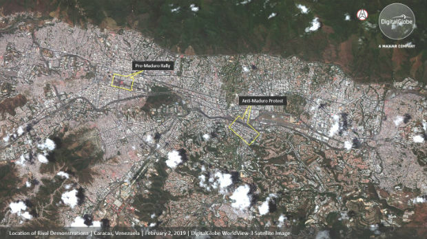
5th February 2019
DigitalGlobe Satellite Imagery: Protests in Caracas, Venezuela5th February 2019
2019 URISA Exemplary Systems in Government Awards Process Opens
5th February 2019
OGC invites you to participate in its UML-to-GML Application Schema31st January 2019
Esri Releases New Updates to ArcGIS Pro 2.3
31st January 2019
thinkWhere Creates Map Portal for Open European Geographic Data
30th January 2019
Garmin® announces enhancements within FltLogic scheduling program
30th January 2019
OGC Announces Open Invitation to Tender for Testbed-15 ESA Threads30th January 2019
Esri Helps Government Agencies Meet New Open Data Law Requirements30th January 2019
Delair opens first customer service centers in the US