Septentrio Introduces “Future Proof” GNSS RTK Technology for Surveyors
18th May 2016
Septentrio Introduces “Future Proof” GNSS RTK Technology for Surveyors18th May 2016
Septentrio Introduces “Future Proof” GNSS RTK Technology for Surveyors18th May 2016
Harris Geospatial Solutions to Offer Icaros OneButton™ with ENVI®18th May 2016
indoo.rs identified as one of the best Indoor Navigation Providers
18th May 2016
The Whole New Update of Leading Mobile GIS—SuperPad 3.3
18th May 2016
Swiss Environmental Consulting Firm Chooses SuperGIS Desktop18th May 2016
Market Intelligence at RECon to be provided by Esri and CCIM Institute
18th May 2016
GSDI 15 World Conference: Menno-Jan Kraak joins keynote speaker lineup18th May 2016
Pitney Bowes Helps Organizations with Geolocation Software Solutions18th May 2016
USGIF Launches Universal GEOINT Certification Program
18th May 2016
Peter Hedlund appointed new Managing Director of OS International18th May 2016
New 3D Modelling application to save money and time18th May 2016
CGG Registered by CNH to Estimate Reserves in Mexico
17th May 2016
Handheld Introduces its First Intrinsically Safe Ultra-Rugged Computer
16th May 2016
LizardTech Launches Express Server 9.5 at GEOINT 2016 Symposium
16th May 2016
OGC's 99th Technical & Planning Committee Meetings Announced15th May 2016
Esri Wins TM Forum Live! Award for Internet of Things Project15th May 2016
Esri Offers Free Webinar on How Communities Can Respond to Zika Virus13th May 2016
1Spatial News: Gold Sponsors of Esri UK Annual Conference
13th May 2016
indoo.rs joins the Wayfindr Alliance to support the visually impaired12th May 2016
Itron Brings Analytic Outcomes as a Service to Utilities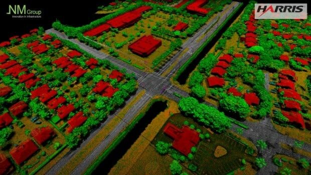
12th May 2016
NM Group collaborate with Harris Corporation
12th May 2016
A GeoPlace commissioned study projects net benefits up to £202 million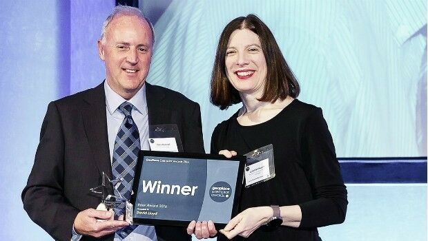
12th May 2016
David Lloyd wins Peer Award at GeoPlace Exemplar Awards
11th May 2016
Esri Ireland & Leica put accuracy into the hands of field workers
11th May 2016
Hyperspectral Imaging and Applications | HSI 2016 Announcement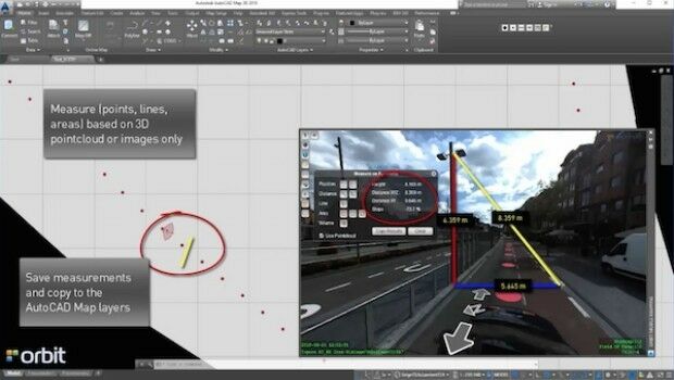
11th May 2016
Orbit GT launches AutoCAD MAP plugin for Mobile Mapping
11th May 2016
The AgriFutureDays have been initiated by the Club of Ossiach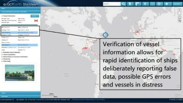
11th May 2016
Knowledge is Power- exactEarth Announces Vital New Information Service
10th May 2016
Earth-i Takes the Best of British to Geospatial World Forum10th May 2016
2016 Esri National Security and Public Safety Summit
10th May 2016
Radiodetection launches new Ground Penetrating Radar systems
10th May 2016
Location Powers the Telecom of the Future at TM Forum Live!
9th May 2016
Free Drone Live-Demo at CAPIGI GeoAgri 2016
9th May 2016
£4 return on every £1 spent on council address and street information
7th May 2016
AgriFutureDays 2016 A must for agriculture or environment related NGOs7th May 2016
Esri Helps Developers Add Geo to Apps at TechCrunch Disrupt NY 20167th May 2016
Design and Develop Web Mapping Apps Using Esri's JavaScript API6th May 2016
Esri UK Customer Success Awards Shortlist Announced
5th May 2016
Award for the Esri Conservation Program Director
5th May 2016
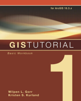
New Esri Workbook for Basic Mapmaking and Spatial Analysis Techniques4th May 2016
Airbus and Hexagon Geospatial Sign Content Agreement for Smart M.App4th May 2016
Partner: Aligned Assets Introduces what3words into Gazetteer Products