Hexagon Geospatial Releases Power Portfolio 2016
18th April 2016
Hexagon Geospatial Releases Power Portfolio 201618th April 2016
Hexagon Geospatial Releases Power Portfolio 2016
18th April 2016
MapAction mobilises humanitarian mapping team for Ecuador earthquake
15th April 2016
eeGeo Joins the Cisco Solution Partner Program15th April 2016
DigitalGlobe Delivers First Phase of Mapping Initiative for Australia14th April 2016
Maptitude Provides Awards & Prizes for AAG Student Paper Competition
14th April 2016
Tri-County Health Department Honors Esri Employee
14th April 2016
Ecometrica becomes Partner for CDP’s water and forest programmes14th April 2016
exactEarth Announce New Strategic Alliance with Larus Technologies14th April 2016
DigitalGlobe to Announce Q1 2016 Financial Results on April 27
13th April 2016
BashNIPIneft LLC selects AVEVA software for major brownfield project13th April 2016
BARTHAUER confirms its participation in IFAT 2016 in Munich13th April 2016
GfK releases 2016 purchasing power for Austria and Switzerland13th April 2016
Topcon announces new machine control dealer in Italy13th April 2016
Leica Geosystems and Spheron-VR collaborate12th April 2016
Golden Software Releases Raster Tools, an Add-in for Esri® ArcMap12th April 2016
Location Data Technology Specialist Blis Raises $25 million
12th April 2016
ISPRS awards Prof. Wolfgang Foerstner with Brock Gold Medal12th April 2016
Coventry Gets Sky Blue View with Bluesky Photomap
12th April 2016
GEO Business 2016 Launches Hard Hitting Conference
11th April 2016
Cambridge collaboration to launch online platform mapping agribusiness11th April 2016
Navmii announces Share my Trip feature with 3.5 app update8th April 2016
KilletSoft realizes Polygonal Validity Scopes in NTv2 grid files
8th April 2016
KilletSoft's geodetic software honored with Innovation Award 20167th April 2016
Public comment on update of OGC Abstract Specification Topic 11
7th April 2016
Kansas City Police Selects Hexagon Safety & Infrastructure Software6th April 2016
Esri Announces 2016 Storytelling with Maps Contest
6th April 2016
GeoPlace endorses transformational power of addresses and street data6th April 2016
Maptitude Team Provides Sponsorship for NEGIS Spring Conference6th April 2016
The new version 6.1 of the PHOTOMOD software family has been released
6th April 2016
Caliper Offers 2016 Census Block Groups Data6th April 2016
Esri Places in Top Ten of Forbes 2016 Best Midsize Employers6th April 2016
GeoSpatial Experts Announces Reseller Agreement with WTH Technology5th April 2016
Hexagon Safety & Infrastructure Software deployed in Phillippines5th April 2016
UK Power Networks and Northumbrian Water sign up to receive OS mapping
5th April 2016
Exprodat Supports OGA Exploration Licence Competition5th April 2016
Team Internet boosts geographic targeting accuracy5th April 2016
Airbus D&S and Thales to produce new digital maps for French defence
4th April 2016
Latest products from Hi-Target Surveying Instrument Co. Ltd2nd April 2016
Elsevier and Society of Exploration Geophysicists Geo Announcement1st April 2016
OGC and ASTM International to Jointly Develop Standards and More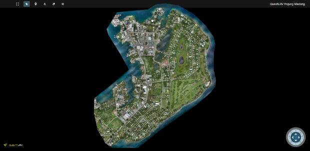
1st April 2016
QuestUAV's South Korean Partner maps Madang, Papua New Guinea1st April 2016
Esri Adds Innovative Web Map Analytics Tool to ArcGIS Marketplace
30th March 2016
Intergraph Utility Network Model extended across the Enterprise30th March 2016
OS reveals winning ideas that will improve our relationship with water