Share
AB Surveying & Development, a surveying solutions firm in the Philippines, has made a significant advancement in marine surveying by adopting the RIEGL VQ-840-G system.
This world-class survey-grade LiDAR scanner is renowned for its precision and non-invasive capabilities. The cutting-edge technology captures data with a nearly elliptical scan pattern, providing comprehensive and detailed views of reefs, sandbars, riverbeds, and coastal terrain—all while ensuring marine life remains undisturbed.
“It is not surprising that, one of the pioneers using RIEGL Airborne sensors on manned aircraft in Southeast Asia, has also become a pioneer using and demonstrating the capabilities of Airborne Laser Bathymetry. And it is also not surprising that this company is from the Philippines. Supported by our regional partners GPS Lands Malaysia since the acquisition of the first airborne systems, they have been able to break new grounds in the use of this technology which, only a few years ago was unimaginable”, said Marcos Garcia, Managing Director of RIEGL Asia Pacific.
As the need to explore and develop marine areas grows—from offshore wind farms and underwater infrastructure to coral reef conservation and environmental research, the demand for responsible exploration of ocean environments has never been greater. The pressure to balance progress with preservation is more intense than ever. Before any construction or protection efforts can commence, understanding what lies beneath is crucial. This begins with collecting precise, reliable data while minimizing disruption to the ecosystems we aim to preserve.
Bathymetric surveying has traditionally relied on boats and sonar equipment to collect seabed data. While effective in deep waters, this method poses risks in shallow zones, potentially damaging delicate coral reefs and sensitive habitats that have taken decades to form. Until recently, there was no practical way to survey shallow marine areas without causing some level of impact.
A Smarter, Non-Invasive Approach
Aerial Bathymetric LiDAR. This specialized remote sensing technology, similar in principle to topographic LiDAR, is designed specifically to map underwater terrain from the air. Mounted on a manned or even unmanned aircraft, it uses green laser light, that can penetrate shallow water and reflect off the seabed to produce detailed, high-resolution data. This allows for the generation of 3D models of underwater features without ever making contact with the water. It’s fast, precise, and most importantly, non-invasive.
The adoption of the RIEGL VQ-840-G system by AB Surveying & Development marks a significant step forward in marine surveying, ensuring that exploration and development can proceed responsibly and sustainably.
“We don’t just survey coastlines—we reveal the unseen and protect what matters most,” Denise Botor, Sales & Marketing Director for AB Surveying & Development. “Because when we see better, we build better.”
Years of Expertise, A Vision for Sustainability
Since its establishment in 1998, AB Surveying & Development has been at the forefront of land and aerial surveying, building decades of expertise. In 2016, the company made a significant leap by pioneering aerial Topographic LiDAR in the Philippines. Today, AB Surveying & Development continues to innovate, venturing into aerial hydrographic surveys to support the country’s growing need for sustainable offshore development and marine data.
In an archipelagic nation like the Philippines, where interest in marine development is rapidly increasing due to its vast potential, the demand for safe, accurate, and efficient marine surveying has never been greater. With a growing focus on offshore energy, marine research, and coastal infrastructure, AB Surveying & Development’s vision has always been to offer smarter, safer solutions. The adoption of RIEGL’s Aerial Bathymetric LiDAR technology has provided a tool that supports both precision and preservation.
Unlike traditional methods that involve dragging equipment through water, Aerial Bathymetric LiDAR operates entirely from above the water surface. This approach eliminates the risk of scratching coral, disturbing marine sanctuaries, or slowing down operations due to terrain or boat limitations.
The green laser used in bathymetric surveying is specifically designed to penetrate shallow water and reflect off the seabed—even in slightly murky conditions. Mounted on a Cessna 172k, this airborne system can cover large areas in far less time than vessel-based surveys. This method is not only more efficient but also smarter, reducing operational risks, protecting ecosystems, and producing high-quality data that developers and researchers can rely on.
Aerial Bathymetric LiDAR requires skill and years of surveying experience. The process involves planning flight paths, precisely calibrating the system, and processing massive amounts of data after each survey. Factors such as water depth, clarity, and seabed type can influence results. If handled incorrectly, poor data quality could lead to misinformed decisions or costly project delays.
AB Surveying & Development has spent years perfecting its process. Through hands-on experience across various marine environments, the company has built the expertise to handle this technology properly. AB Surveying & Development is not just operating an advanced tool—they understand how to make it deliver results that clients can trust.
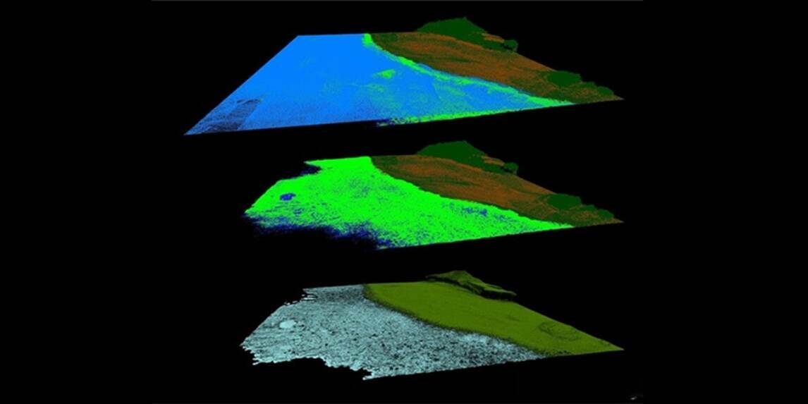
The Batangas Reef Project with the RIEGL VQ-840-G
In a groundbreaking project in Batangas, AB Surveying & Development showcased the power of their advanced surveying technology. Tasked with assessing the health and structure of a coral reef without disturbing it, the team faced a significant challenge. Traditional survey methods were not an option due to the risk of damaging the delicate ecosystem.
Instead, AB Surveying & Development employed their state-of-the-art RIEGL LiDAR system to fly over the site, completing data collection quickly and safely. This approach eliminated the need for divers, boats, or any direct contact with the reef.
The result was a high-resolution, highly accurate map of the reef system, providing marine researchers and planners with the crucial data needed to make informed decisions while leaving the environment untouched.
This project proved that reliable bathymetric data can be obtained while protecting marine ecosystems. For AB Surveying & Development, this represents the future of surveying, combining precision with preservation to support sustainable marine development.
Watch a Fly Through video of the Batangas Reef Project
The Future of Surveying
AB Surveying & Development, with the support of RIEGL’s regional distributor GPS Land Malaysia, has become the first in Southeast Asia to utilize Aerial Bathymetric LiDAR, specifically the RIEGL VQ-840-G, through manned aircraft. This innovative technology is more than just a new advancement, it’s a smarter, cleaner way to understand our oceans and coasts.
“We are proud of our long-standing and successful collaboration with AB Surveying & Development, now approaching a decade”. said CS Lim, Managing Director of GPS Lands (M) Sdn. Bhd. “From their very first deployment of the Airborne Topographic LiDAR system to the expansion into Airborne Bathymetric LiDAR, it is inspiring to see RIEGL’s advanced technologies supporting the growth of the Philippines geospatial industry. Under the capable leadership of Mr. Tony Botor, AB Surveying & Development has not only advanced geospatial capabilities but also contributed meaningfully to ESG initiatives through responsible environmental monitoring and sustainable land-use planning.”
Aerial Bathymetric LiDAR helps balance development with preservation, providing planners and researchers with the tools to move forward without compromising sustainability. Whether mapping coral reefs, planning coastal infrastructure, or managing marine resources, AB Surveying & Development’s bathymetric surveying offers speed, accuracy, and minimal environmental impact.
AB Surveying & Development’s pioneering efforts in Batangas demonstrated the effectiveness of this approach. Tasked with assessing the health and structure of a coral reef without disturbing it, the team utilized their LiDAR system to fly over the site, completing data collection quickly and safely. The result was a high-resolution, highly accurate map of the reef system, providing marine researchers and planners with crucial data while leaving the environment untouched.
This project proved that reliable bathymetric data can be obtained while protecting marine ecosystems. For AB Surveying & Development, this represents the future of surveying, combining precision with preservation to support sustainable marine development.
Subscribe to our newsletter
Stay updated on the latest technology, innovation product arrivals and exciting offers to your inbox.
Newsletter

