
Icaros Releases 4.2.2 of OneButton™ UAS Image Processing Software
22nd June 2016
Icaros Releases 4.2.2 of OneButton™ UAS Image Processing Software22nd June 2016
Icaros Releases 4.2.2 of OneButton™ UAS Image Processing Software21st June 2016
LandWorks Introduces New Spatial Alignment Tool at Esri Conference21st June 2016
Spirent Announces World’s Smallest 16-bit Record and Playback System
21st June 2016
Fugro Deploys Q1400 Trenchers at Three North Sea Oil and Gas Projects21st June 2016
Small Vessel Tracking Trials, a Success in South Africa
21st June 2016
BARTHAUER acquires pilot customer for cooperation in Serbia21st June 2016
Cornerstone Mapping Processing Thermal Imagery with SimActive
20th June 2016
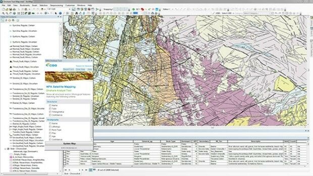
CGG GeoConsulting introduces EARS BasinMap20th June 2016
MICROMINE’s Pitram allows mine operators greater control
16th June 2016
Leica Geosystems expands LiDAR capabilities in ALS80 airborne sensor16th June 2016
UAVAir calls businesses to take note of growing use of drones
16th June 2016
RuggON's new rugged tablet puts cutting-edge tech in hands of the law
16th June 2016
Age of Drones Expo is coming: first time in Hamburg, Germany
15th June 2016
New Industrial Supervision & Control Solution
15th June 2016
Leica Geosystems establishes georadar portfolio
15th June 2016
Specim announces new hyperspectral camera series for industrial needs
15th June 2016
Groupo Mexico honored for shaping smart change
14th June 2016
Hexagon Unveils Latest Intergraph Computer-Aided Dispatch Software14th June 2016
Acquisition of Exprodat Consulting Ltd by Getech Group plc
14th June 2016
£8 million monsoon project launches in India
14th June 2016
£8 million monsoon project launches in India
13th June 2016
AECOM collaborates with Trimble on the use of HoloLens technology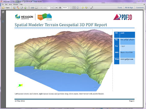
13th June 2016
PDF3D Releases 3D Geospatial PDF Plugin for ERDAS IMAGINE
13th June 2016
Aero Surveillance announces a new version of its Octocopter ASV 3010th June 2016
Meet the Geode™—A Rugged Sub-Meter GNSS Receiver10th June 2016
exactEarth Providing S-AIS Services to French Navy10th June 2016
OriginGPS and Sierra Wireless Strike New Partnership
10th June 2016
Plowman Craven wins Parliament BIM & scanning contract
10th June 2016
Mobile mapping – The Future has arrived for MK Surveys
9th June 2016
Topcon introduces new Professional Services team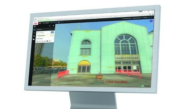
8th June 2016
Leica Geosystems releases new software capabilities


7th June 2016
Leica Lino ML180 saves costs with smart one-man operation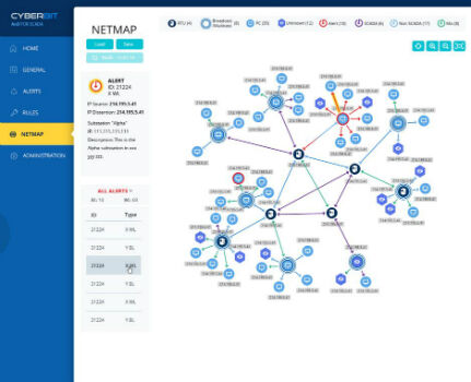
6th June 2016
CYBERBIT Introduces SCADAShield 5.0 at Infosecurity Europe 20164th June 2016
SonarMite™ Drivers now Available for Trimble Access Field Software
3rd June 2016
Topcon and Bentley integration between MAGNET 4.0 and ProjectWise2nd June 2016
Registration Now Open for Trimble Dimensions 2016 User Conference1st June 2016
Topcon announces increased integration with Autodesk scanning software1st June 2016
First three subcontractors selected by OneWeb Satellites1st June 2016
Research report - Royal Mail Data Services - data-driven marketing_attribute_to_CIMBALY-V.jpg)
1st June 2016
Globalstar’s SPOT Gen3 helps with rescues during Marathon Des Sables
1st June 2016
Handheld Adds eTicketing Capabilities to its ALGIZ RT7 Rugged Tablet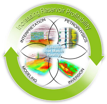
1st June 2016
CGG GeoSoftware Integrates Geoscience Disciplines