
Blue Marble Teams Up with Pointerra to Provide Cloud-Based LiDAR Data
31st January 2017
Blue Marble Teams Up with Pointerra to Provide Cloud-Based LiDAR DataThe compilation, reproduction and dissemination of maps and charts by means of manual (analogue) or digital techniques, tools and workflows. This topic covers the compilation, reproduction, dissemination and use of both analogue (paper) and digital maps, charts and atlases. As well as the science of cartography, including georeferencing and geocoding, digital techniques for compiling and generating various types of raster and vector maps and charts are covered, as are the digital mapping tools and Geographic Information Systems available for this purpose. The application of cartography for aeronautical, terrestrial and marine purposes is also covered
31st January 2017
Blue Marble Teams Up with Pointerra to Provide Cloud-Based LiDAR Data31st January 2017
WorldStores Maps Out Optimised Routes with Maxoptra30th January 2017
RIEGL’s Notable Week at Geospatial World Forum 2017!29th January 2017
Cyberbit to showcase hyper-realistic cybersecurity simulator28th January 2017
LGA calls for lorry drivers to use commercial sat navs28th January 2017
Lorry drivers must use commercial satnavs, say councils28th January 2017
New High Performance Chirp Side Scan Sonar System27th January 2017
Virtual World Asset Management delivered to the Power Industry
27th January 2017
Terra Drone establish new branch in Australia, Brisbane.
27th January 2017
UNIFLY Winner of Best Emerging EU Drone Company27th January 2017
Announcing Shipping2030 Europe, co-located with Green Ship Technology26th January 2017
Requests for geocoding rising after Google changes pricing policy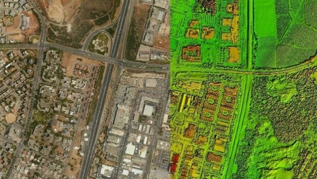
26th January 2017
New Trimble Technology Lab Gift to UMass Amherst
26th January 2017
Hexagon Safety & Infrastructure Launches New Police Analytics Software26th January 2017
Orbit GT and Shanghai Topcon-Sokkia (STS), sign Reseller Agreement26th January 2017
Next-Generation Geolocation for IoT from Abeeway and Actility26th January 2017
Kullasoft release the Android version of the PGM Manager app26th January 2017
OGC Calls for Participation in Major Innovation Testbed (Testbed 13)25th January 2017
High-Speed Connectivity to Civilian Armored Vehicles
25th January 2017
Abstract Submissions Invited for GIS-Pro 2017 in Jacksonville, Florida
25th January 2017
IMCA Guidance Demonstrates the Strength of Working Together25th January 2017
New project to boost Sat Nav positioning accuracy anywhere in world25th January 2017
In focus: The state of sewer management system technology25th January 2017
New measurement solution for optimization of LTE / 4G networks25th January 2017
40 Years of Educating Communications Technology Professionals25th January 2017
PCI Selects Sole Authorized Reseller in Ecuador25th January 2017
COSMO-SkyMed data and services for the Japanese government
25th January 2017
Pix4D speaks at UN Panel on Food Security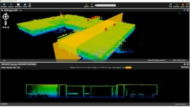
25th January 2017
Orbit GT releases Indoor Mapping solution with Floor Plan Builder25th January 2017
Propulsion test module for the Orion programme delivered to NASA
24th January 2017
Airport GIS | LiDAR, imagery and feature extraction for airport operations24th January 2017
TomTom and Mappy extend their long-term relationship23rd January 2017
TrackR launches updated Find My Phone Skill for Amazon Alexa_and_Fergus_Noble_(R)_co-founde-e240cc279eaa83b2be814504fc94555b.jpg)
20th January 2017
Seabed Geosolutions Mobilises For OBN Survey In West Africa
20th January 2017
AGI and Bentley Systems Announce Cesium Consortium20th January 2017
Airbus ready to ship Aeolus for final testing ahead of launch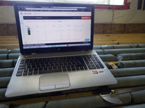
20th January 2017
Geosoft and Minalytix partner to bring MX Deposit to the marketplace19th January 2017
URISA 2017 Exemplary Systems in Government Awards Process Opens19th January 2017
Dates and Venues Unveiled For GeoDATA 2017 Showcase Series19th January 2017
Map maker AND releases ZIP+4 Code Boundaries for the USA19th January 2017
Airbus provides satellite communications for the French administration