
Cartography
The compilation, reproduction and dissemination of maps and charts by means of manual (analogue) or digital techniques, tools and workflows. This topic covers the compilation, reproduction, dissemination and use of both analogue (paper) and digital maps, charts and atlases. As well as the science of cartography, including georeferencing and geocoding, digital techniques for compiling and generating various types of raster and vector maps and charts are covered, as are the digital mapping tools and Geographic Information Systems available for this purpose. The application of cartography for aeronautical, terrestrial and marine purposes is also covered
Royal Greenwich recognised as smart city innovator
9th November 2017
Royal Greenwich recognised as smart city innovator
Garmin's availability of visual approach guidance for the GTN 650/750
8th November 2017
Garmin's availability of visual approach guidance for the GTN 650/750Elbit Systems’ Seagull™ Won Maritime Award: “KNVTS Ship of the Year"
8th November 2017
Elbit Systems’ Seagull™ Won Maritime Award: “KNVTS Ship of the Year"
OGC invites you to its Testbed 13 Demonstration Event
8th November 2017
OGC invites you to its Testbed 13 Demonstration Event
West Yorkshire Police adopt Trimble SX10 technology
8th November 2017
West Yorkshire Police adopt Trimble SX10 technologyBureau Veritas class CMA CGM’s LNG fuelled ultra-large containerships
8th November 2017
Bureau Veritas class CMA CGM’s LNG fuelled ultra-large containerships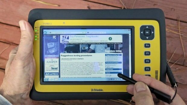
Introducing new high-performance, large screen Trimble T10 tablet
8th November 2017
Introducing new high-performance, large screen Trimble T10 tablet
Popular URISA Program to be Offered Twice in 2018
7th November 2017
Popular URISA Program to be Offered Twice in 2018
ADC WorldMap Releases Digital Atlas Version 7.4
7th November 2017
ADC WorldMap Releases Digital Atlas Version 7.4
European purchasing power climbs by a nominal 1.9 percent
7th November 2017
European purchasing power climbs by a nominal 1.9 percent
Corsica Linea to take vessel performance management to the next level
6th November 2017
Corsica Linea to take vessel performance management to the next level
Connected Vehicle Camera Footage Highlights Dangers of Rural Roads
3rd November 2017
Connected Vehicle Camera Footage Highlights Dangers of Rural Roads
Phase One Industrial partners with Drone Nerds
3rd November 2017
Phase One Industrial partners with Drone Nerds
Oxfordshire County Council looks to GIS to transform service delivery
3rd November 2017
Oxfordshire County Council looks to GIS to transform service delivery
Pitney Bowes and Arrow Electronics sign Agreement
2nd November 2017
Pitney Bowes and Arrow Electronics sign Agreement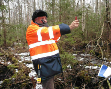
Globalstar’s SPOT Gen3 to Protect Forest Workers Across France
2nd November 2017
Globalstar’s SPOT Gen3 to Protect Forest Workers Across France
Airbus-built EchoStar 105/SES-11 satellite now in geostationary orbit
2nd November 2017
Airbus-built EchoStar 105/SES-11 satellite now in geostationary orbit
Fugro Features Innovative Solutions at ADIPEC 2017
2nd November 2017
Fugro Features Innovative Solutions at ADIPEC 2017
Swift Enhances its Centimeter-Accurate GNSS Technology
1st November 2017
Swift Enhances its Centimeter-Accurate GNSS Technology
Impressions from the SCADA Security Conference
1st November 2017
Impressions from the SCADA Security Conference
2018 ISPRS Call for Educational and Capacity Building Initiative
1st November 2017
2018 ISPRS Call for Educational and Capacity Building Initiative
OGC seeks public comment on TimeseriesML 1.2 Candidate Standard
31st October 2017
OGC seeks public comment on TimeseriesML 1.2 Candidate Standard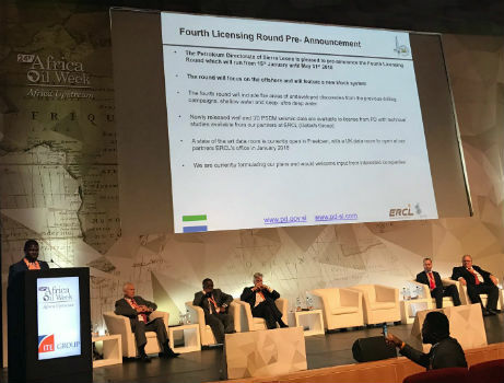
Sierra Leone Makes Fourth Licensing Round Pre-Announcement
31st October 2017
Sierra Leone Makes Fourth Licensing Round Pre-Announcement
SimActive Automates Direct Georeferencing
31st October 2017
SimActive Automates Direct Georeferencing
Slovenia and HERE partner to improve highway safety
31st October 2017
Slovenia and HERE partner to improve highway safety
BIM Alliance & buildingSMART UK&I Chapter Announce a Merger
30th October 2017
BIM Alliance & buildingSMART UK&I Chapter Announce a Merger
CGG Delivers Final PSDM Products for Cairenn Multi-Client Survey
30th October 2017
CGG Delivers Final PSDM Products for Cairenn Multi-Client Survey
Smart Cities Will Not Thrive Without National Policy Support
30th October 2017
Smart Cities Will Not Thrive Without National Policy Support
Helping Councils get the Most from Infrastructure Asset Management
30th October 2017
Helping Councils get the Most from Infrastructure Asset Management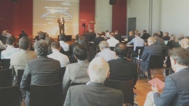
WorldView Global Alliance User Conference 2017 Report
28th October 2017
WorldView Global Alliance User Conference 2017 Report
OGC supports American Geographical Society’s 2017 Fall Symposium
27th October 2017
OGC supports American Geographical Society’s 2017 Fall Symposium
Topcon helps DEC! develop maths skills that are fit for site
27th October 2017
Topcon helps DEC! develop maths skills that are fit for site
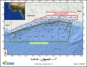
CGG Awarded Contract for Licenses in Côte d’Ivoire
26th October 2017
CGG Awarded Contract for Licenses in Côte d’Ivoire.jpg)
Fugro Applies Seeps Expertise To Canada’s Growing Offshore Industry
26th October 2017
Fugro Applies Seeps Expertise To Canada’s Growing Offshore Industry
Commercial UAV Expo and Drone World Expo Come Together in 2018
26th October 2017
Commercial UAV Expo and Drone World Expo Come Together in 2018
Smart City Capabilities at Smart City Expo World Congress 2017
26th October 2017
Smart City Capabilities at Smart City Expo World Congress 2017
GfK releases updated maps for all of Europe
26th October 2017
GfK releases updated maps for all of Europe
OS International partners with Tanzania and the World Bank
26th October 2017
OS International partners with Tanzania and the World Bank
Orbit GT updates 3D Mapping Cloud with great new UAV support
26th October 2017
Orbit GT updates 3D Mapping Cloud with great new UAV support