
Cartography
The compilation, reproduction and dissemination of maps and charts by means of manual (analogue) or digital techniques, tools and workflows. This topic covers the compilation, reproduction, dissemination and use of both analogue (paper) and digital maps, charts and atlases. As well as the science of cartography, including georeferencing and geocoding, digital techniques for compiling and generating various types of raster and vector maps and charts are covered, as are the digital mapping tools and Geographic Information Systems available for this purpose. The application of cartography for aeronautical, terrestrial and marine purposes is also covered


GeoPlace recognises ‘Britain’s Most Fantastic Address’
28th January 2019
GeoPlace recognises ‘Britain’s Most Fantastic Address’
Globalstar launches SPOT X two-way satellite tracker
28th January 2019
Globalstar launches SPOT X two-way satellite tracker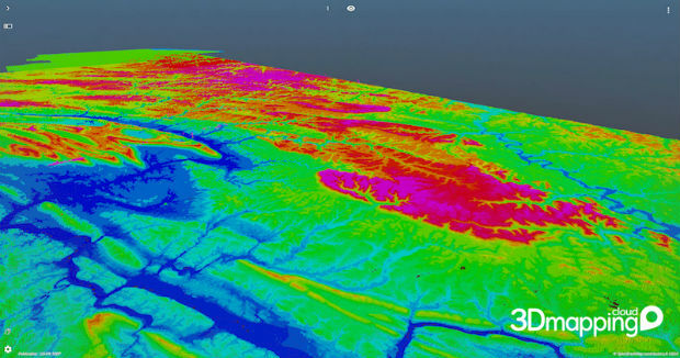
Orbit GT brings 3DEP online on 3D Mapping Cloud
25th January 2019
Orbit GT brings 3DEP online on 3D Mapping Cloud
Elaine Lewis becomes Non-Executive Director
25th January 2019
Elaine Lewis becomes Non-Executive Director
CSA Recognized as PEC Safety Authorized Provider
25th January 2019
CSA Recognized as PEC Safety Authorized Provider
OGC Calls for Speakers for its Marine Summit in Singapore
25th January 2019
OGC Calls for Speakers for its Marine Summit in Singapore
UK Hydrographic Office welcomes Department for Transport’s Maritime 2050 strategy
25th January 2019
UK Hydrographic Office welcomes Department for Transport’s Maritime 2050 strategy
Sky and Space Global Shortlisted for the Best Mobile Innovation
24th January 2019
Sky and Space Global Shortlisted for the Best Mobile Innovation
Airbus completes System Requirements Review
24th January 2019
Airbus completes System Requirements Review

Leica BLK3D Recognised by Prestigious Global Awards
24th January 2019
Leica BLK3D Recognised by Prestigious Global Awards
thinkWhere Helps Falkirk Tackle Poverty with Open Geographic Data
24th January 2019
thinkWhere Helps Falkirk Tackle Poverty with Open Geographic Data
New bathymetric capabilities with CARIS software
23rd January 2019
New bathymetric capabilities with CARIS software
Telefónica and Samsung Utilize LuxCarta’s Advanced Geodata
23rd January 2019
Telefónica and Samsung Utilize LuxCarta’s Advanced Geodata
Virtual Surveyor 6.2 Now Processes Larger Drone Survey Projects
23rd January 2019
Virtual Surveyor 6.2 Now Processes Larger Drone Survey Projects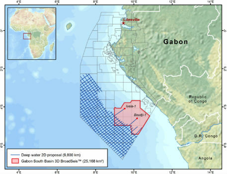
New CGG Survey Supports Gabon’s 12th Offshore Licensing Round
23rd January 2019
New CGG Survey Supports Gabon’s 12th Offshore Licensing Round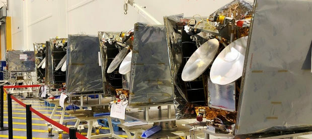
OneWeb Satellites has shipped first satellites
23rd January 2019
OneWeb Satellites has shipped first satellites
Bridgestone Europe To Acquire Tomtom Telematics
23rd January 2019
Bridgestone Europe To Acquire Tomtom Telematics
Andy Boutle, Sarah Davidson & Shaun Farrell join the UK BIM Alliance
23rd January 2019
Andy Boutle, Sarah Davidson & Shaun Farrell join the UK BIM Alliance
Geovation Programme returns for 2019 to help start-ups break through
21st January 2019
Geovation Programme returns for 2019 to help start-ups break through
Fugro Uses Rapid Airborne Multibeam Mapping System (RAMMS)
19th January 2019
Fugro Uses Rapid Airborne Multibeam Mapping System (RAMMS)
The Alliance Future Surveillance and Control Programme
19th January 2019
The Alliance Future Surveillance and Control Programme
Defence IQ releases annual Airborne ISR and C2 Battle Management Global Market Report
19th January 2019
Defence IQ releases annual Airborne ISR and C2 Battle Management Global Market Report
ITS European Congress 2019: Welcome to Europe’s hub for innovation
19th January 2019
ITS European Congress 2019: Welcome to Europe’s hub for innovation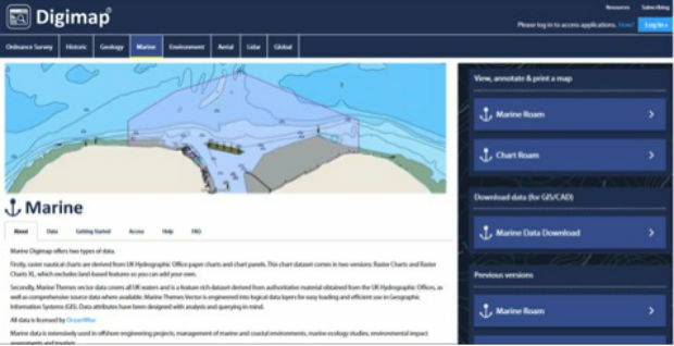
Students and Researchers now benefit from access to OceanWise Marine Mapping via Digimap™
19th January 2019
Students and Researchers now benefit from access to OceanWise Marine Mapping via Digimap™
Fugro Enhances IRM Capability With New Edda Sun ROV Support Vessel
19th January 2019
Fugro Enhances IRM Capability With New Edda Sun ROV Support Vessel
Coventry Synergy: Cc Europe & Bapco Conference Combine For Max Impact
17th January 2019
Coventry Synergy: Cc Europe & Bapco Conference Combine For Max Impact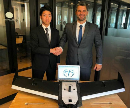
Terra Drone Japan and Plimsoll UAV in Brazil sign a joint venture agreement
17th January 2019
Terra Drone Japan and Plimsoll UAV in Brazil sign a joint venture agreement
Routescene and Caddis Aerial launch UAV LiDAR surveys
17th January 2019
Routescene and Caddis Aerial launch UAV LiDAR surveys
Sercel and Apave Enter Strategic Partnership
17th January 2019
Sercel and Apave Enter Strategic Partnership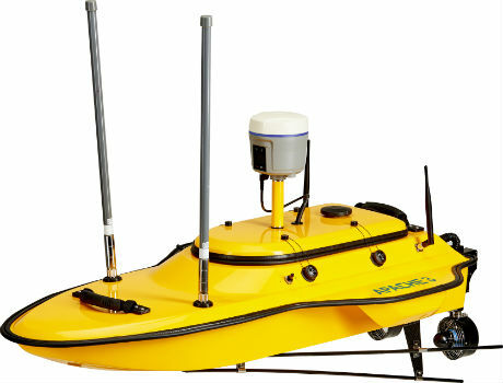
CHC Navigation introduces the APACHE 3 portable USV Solution.
17th January 2019
CHC Navigation introduces the APACHE 3 portable USV Solution.
Hexagon introduces rugged industrial computers for mining industry
16th January 2019
Hexagon introduces rugged industrial computers for mining industry
Delair announces interoperability of high-precision PPK drone data
16th January 2019
Delair announces interoperability of high-precision PPK drone data
Garmin® TeamX introduces the GTR 200B comm radio with Bluetooth®
16th January 2019
Garmin® TeamX introduces the GTR 200B comm radio with Bluetooth®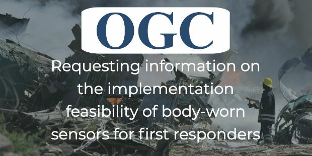
Feasibility of Guidance for First Responder Body-worn Sensors
16th January 2019
Feasibility of Guidance for First Responder Body-worn Sensors
Hexagon’s Geospatial Division Releases Luciad V2018.1
16th January 2019
Hexagon’s Geospatial Division Releases Luciad V2018.1
Making History With The Help Of Topcon Technology
16th January 2019
Making History With The Help Of Topcon Technology
ERM Advanced Telematics Targets Car Sharing Market
16th January 2019
ERM Advanced Telematics Targets Car Sharing Market
CGG Continues to Expand Anadarko Basin Library
16th January 2019
CGG Continues to Expand Anadarko Basin Library

OGC Seeks Public Comment on GroundwaterML v2.3 Candidate Standard
16th January 2019
OGC Seeks Public Comment on GroundwaterML v2.3 Candidate Standard
Fugro To Deploy Unique Rila Technology In Network Rail Contract Win
16th January 2019
Fugro To Deploy Unique Rila Technology In Network Rail Contract Win
New member appointed to the GeoPlace Board
14th January 2019
New member appointed to the GeoPlace Board
Staying a Step Ahead of Increasingly-Sophisticated Cyber Threats
14th January 2019
Staying a Step Ahead of Increasingly-Sophisticated Cyber Threats