
News
News as it happens! Keep in touch with the latest developments in business and technology in the regions or worldwide.

Woolpert’s mapping and surveying experiences leads to work in Colorado, Indianapolis
16th September 2020
Woolpert’s mapping and surveying experiences leads to work in Colorado, Indianapolis
Virtual Surveyor introduces new feature to drone surveying software
16th September 2020
Virtual Surveyor introduces new feature to drone surveying software
MGISS Reveals Underground Highway Assets for Sir Robert McAlpine
16th September 2020
MGISS Reveals Underground Highway Assets for Sir Robert McAlpine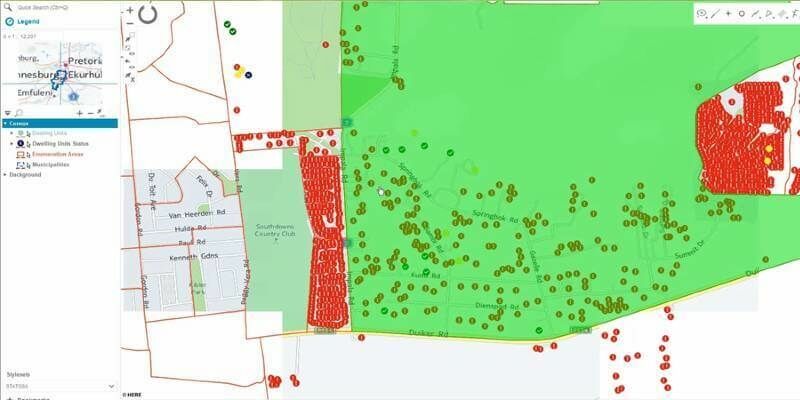
Hexagon Unveils HxGN Smart Census 2020 for Enhanced Citizen Data Collection
16th September 2020
Hexagon Unveils HxGN Smart Census 2020 for Enhanced Citizen Data Collection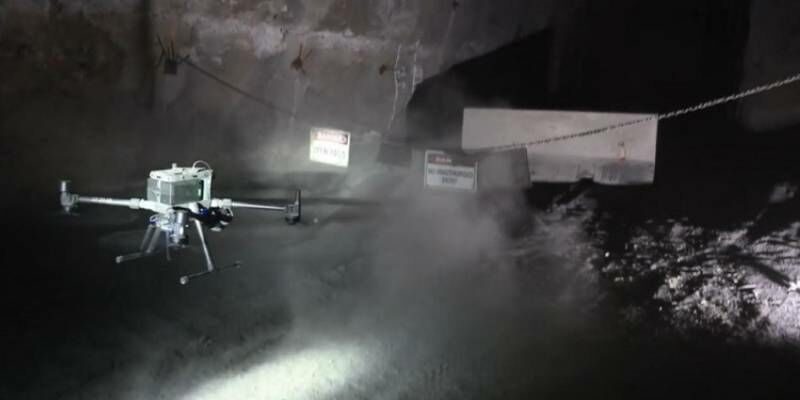
Emesent helps DJI M300 fly autonomously underground
15th September 2020
Emesent helps DJI M300 fly autonomously underground
Prashant Shukle receives OGC Lifetime Achievement Award
15th September 2020
Prashant Shukle receives OGC Lifetime Achievement Award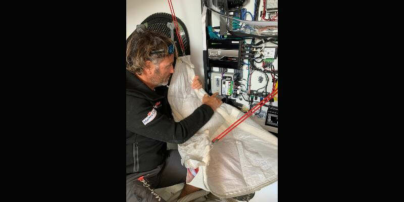
Spectra Geospatial SP90m GNSS Receiver Chosen for Single-handed Around-the-World Yacht Race
15th September 2020
Spectra Geospatial SP90m GNSS Receiver Chosen for Single-handed Around-the-World Yacht Race
Wildfire Webinar: A Platform to Help Save Lives and Nature
15th September 2020
Wildfire Webinar: A Platform to Help Save Lives and Nature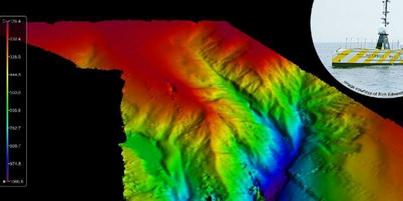
Teledyne CARIS Mira AI software contributes to successful UTAS UAV Mission
13th September 2020
Teledyne CARIS Mira AI software contributes to successful UTAS UAV Mission
Unmanned Aircraft Selected to Support Site Acceptance Testing of North Dakota’s Statewide BVLOS Network
13th September 2020
Unmanned Aircraft Selected to Support Site Acceptance Testing of North Dakota’s Statewide BVLOS Network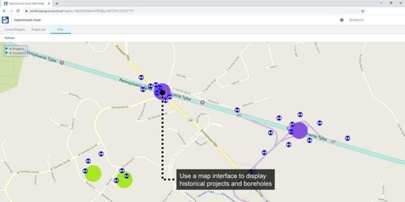
Bentley Systems Announces Availability of OpenGround Cloud to Increase the Value of Geotechnical Data
13th September 2020
Bentley Systems Announces Availability of OpenGround Cloud to Increase the Value of Geotechnical Data
2020 Commercial UAV Expo Americas to Take Place Virtually This Week
13th September 2020
2020 Commercial UAV Expo Americas to Take Place Virtually This Week
Support for 3D Vision Pro canceled by NVIDIA! The alternative by Schneider Digital is the 3D PluraView stereo monitor
11th September 2020
Support for 3D Vision Pro canceled by NVIDIA! The alternative by Schneider Digital is the 3D PluraView stereo monitor
thinkWhere Appoints Louise Barnes as Chief Commercial Officer
11th September 2020
thinkWhere Appoints Louise Barnes as Chief Commercial Officer
RoadCloud to offer premium road data on the HERE Marketplace
11th September 2020
RoadCloud to offer premium road data on the HERE Marketplace
Fugro's Major Upgrade To Lads Technology Improves Hydrographic Data Collection In Australia And Pacific Region
11th September 2020
Fugro's Major Upgrade To Lads Technology Improves Hydrographic Data Collection In Australia And Pacific Region
New virtual experience for the critical communications industry opens for registration
11th September 2020
New virtual experience for the critical communications industry opens for registration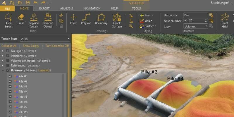
Virtual Surveyor Offers Enhanced Functionality in Free Version of Drone Surveying Software
10th September 2020
Virtual Surveyor Offers Enhanced Functionality in Free Version of Drone Surveying Software
Golden Software Improves Surfer File Handling for Faster Mapping
10th September 2020
Golden Software Improves Surfer File Handling for Faster Mapping
Esri Acquires nFrames to Enhance Its 3D Capabilities
10th September 2020
Esri Acquires nFrames to Enhance Its 3D Capabilities
Smarter Data, Smarter World goes digital for 2020
10th September 2020
Smarter Data, Smarter World goes digital for 2020
Save time and speed up image processing & analysis
9th September 2020
Save time and speed up image processing & analysis