Leica iCON now supports Excidor AB tilt rotator control system
30th August 2017
Leica iCON now supports Excidor AB tilt rotator control systemThe 2D and 3D measurement of points, distances and angles of features and objects on the Earth’s surface. See also Surveying Instrumentation topic. This topic covers the science and techniques that govern the 2D and 3D measurement of points, distances and angles of natural and man-made features and objects on the Earth’s surface. These measurements are acquired for a wide range of practical applications in construction, engineering, land use planning, mapmaking and cadastral projects, See also Surveying Instrumentation topic for the various tools employed to acquire survey measurements.
30th August 2017
Leica iCON now supports Excidor AB tilt rotator control system
30th August 2017
Sentinel-5 Precursor begins final journey to launch site
30th August 2017
RIMS BV first approved service supplier to Bureau Veritas29th August 2017
Integrated Drone Multispectral Mapping Solution for Agriculture29th August 2017
CGG Starts Espirito Santo IV survey offshore Brazil29th August 2017
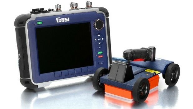
GSSI Showcases Newest GPR Equipment at Damage Prevention Symposium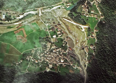
28th August 2017
Seen From Space: Landslide in the Swiss Alps
23rd August 2017
Multiple senseFly drones added to the list of compliant systems
23rd August 2017
Juniper Systems Limited Opens New Office, Welcomes Birgit Krassnitzer23rd August 2017
CCLD Takes Delivery of the RIEGL VUX-SYS!
23rd August 2017
Real-time imagery for firefighters saves lives
22nd August 2017
Atlas Dynamics to Launch Autonomous Professional Drone System21st August 2017
Pointfuse V3 Point Cloud Software Announced
16th August 2017
New rugged GPS receiver for marine surveyors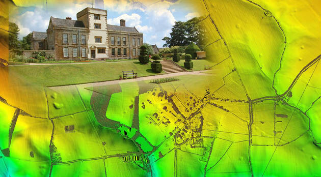
9th August 2017
Bluesky LiDAR Helps ArcHeritage Reveal Hidden Treasures
2nd August 2017
The data behind the search for MH370: Phase One data released
31st July 2017
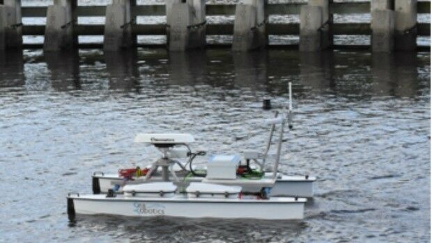
SeaRobotics Wins Contract for Autonomous Hydrographic Survey Vehicles27th July 2017
GeoCue GNSS Direct Geopositioning System For Low Cost DJIDrones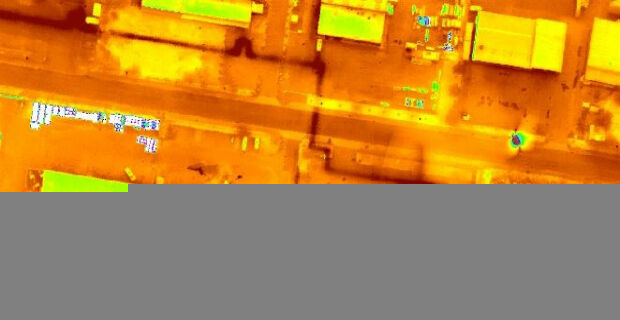
27th July 2017
Icaros and TeAx Announce an Integrated Drone Mapping Solution27th July 2017
Trimble Introduces New Android Application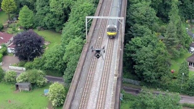
24th July 2017
Plowman Craven Launches Vogel R3D Rail Survey System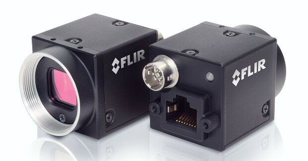
24th July 2017
FLIR Releases FLIR Blackfly S GigE Machine Vision Camera Family22nd July 2017
Teledyne Odom MB2 multi beam system for Teesport UK19th July 2017
Yotta Seals Partnership with Engineering Consultancy Giant Ramboll14th July 2017
New Engineering Focus on Developing Customized GPR Solutions
13th July 2017
Bluesky Launches Nationwide Map of Building Heights11th July 2017
CATSURVEYS Launches their Purpose Driven Brand10th July 2017
Obstacle Obstruction Survey at Massachusetts Airport6th July 2017
Trimble Catalyst: High-Accuracy, On-Demand Positioning-as-a-Service6th July 2017
Trimble Catalyst: High-Accuracy, On-Demand Positioning-as-a-Service
6th July 2017
senseFly announces worry-free service package
4th July 2017
Repair And Maintenance Services For Petrobras In Brazil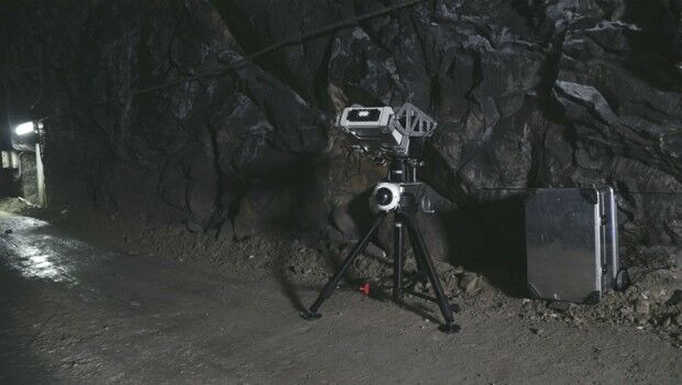
29th June 2017
Safety, stability monitoring radar for the underground mining industry29th June 2017
Elsevier and the Bureau of Economic Geology Partnership
29th June 2017
Scientists investigate link between air pollution and type 2 diabetes
28th June 2017
senseFly brings drone education to Esri User Conference27th June 2017
OS to map out greener communities at NWG Innovation Festival27th June 2017
Trimble Launches VRS Now Correction Service in France
22nd June 2017
Applanix Workshop on Direct Georeferencing for Airborne Mapping & Surveying
21st June 2017
Drone Inspections go nuclear with GPS and RADAR
20th June 2017
Fugro Returns to Borssele Offshore Wind Farm Zone to Survey for UXO
20th June 2017
What Depth can you Locate a Utility Service?

16th June 2017
Leica Geosystems’ GNSS networks now support Galileo, QZSS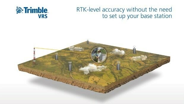
16th June 2017
Trimble Adds Galileo Support to its VRS Now Correction Service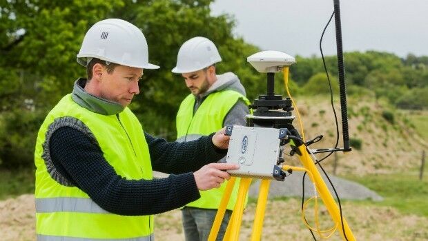
16th June 2017
Surveyors Provided with a Powerful Multi-application GNSS Solution