Customer-Driven Improvements Highlight Carlson Survey 2018
7th September 2017
Customer-Driven Improvements Highlight Carlson Survey 20187th September 2017
Customer-Driven Improvements Highlight Carlson Survey 20186th September 2017
Several Improvements Made in the Latest Version of SuperGIS Desktop 106th September 2017
SuperSurv Assists Ecological Research in France6th September 2017
Airborne mapping system from 3D Laser Mapping takes off5th September 2017
SimActive Releases Correlator3D™ Version 7.05th September 2017
SCADA Security Conference 2017 in Prague, Czech Republic4th September 2017
Orbit GT and Nordic GeoCenter, Finland, sign Reseller Agreement2nd September 2017
Bentley Systems' 2017 Be Inspired Awards Program1st September 2017
Free Global Mapper to Organizations Responding to Hurricane Harvey1st September 2017
Drones and Pix4D drone mapping software saving time and money1st September 2017
MapAction Announces New Director of Fundraising & Marketing31st August 2017
CGG signs agreement with Mozambique Ministry
30th August 2017
SuperPad Will Support the Popular MBTiles Format in the Next Update
30th August 2017
Hydracos Selects SuperPad for Water Utility Inspection30th August 2017
OGC is seeking participants for its GeoPackage (GPKG)30th August 2017
Astun Technology Supports Most Successful FOSS4G Ever29th August 2017
Integrated Drone Multispectral Mapping Solution for Agriculture29th August 2017
Geographical mismatches between capacity and need hinders Conservation29th August 2017
Informed Solutions Celebrate 25 Years of Success!29th August 2017
OSNI digital mapping now available through viaEuropa web service29th August 2017
CGG Starts Espirito Santo IV survey offshore Brazil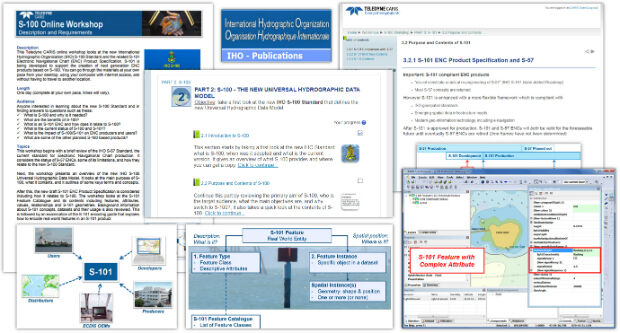
29th August 2017
Teledyne CARIS Releases S-100 Online Workshop29th August 2017
GIS Cloud Exhibiting at the INTERGEO 2017 in Berlin
29th August 2017
McCarthy & Stone select Cadcorp software for more efficient Workforce Planning28th August 2017
SPOT 6/7 imagery for improved efficiency of US agriculture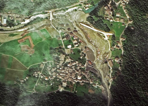
28th August 2017
Seen From Space: Landslide in the Swiss Alps24th August 2017
Free Healthcare Data for Use with Maptitude Mapping Software24th August 2017
SuperGIS 3D Solutions to View Cities from Different Angles24th August 2017
Learn Advanced Tools and Analysts with SuperGIS Online Manuals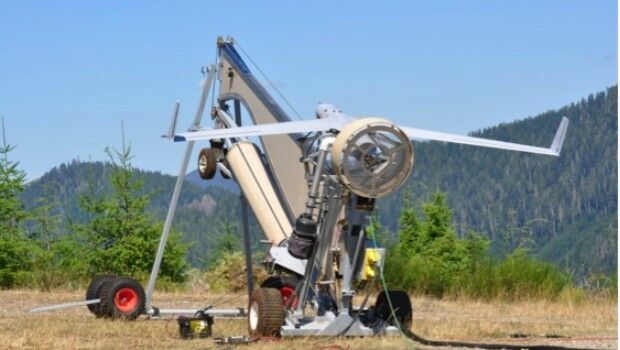
23rd August 2017
Real-time imagery for firefighters saves lives22nd August 2017
Caliper Corporation: 2017 Sustained Growth22nd August 2017
1Spatial grows its team of Safe Software FME Certified Trainers20th August 2017
Maptitude Sponsorship for MGGG Geometry of Redistricting Workshops17th August 2017
The Science of Where to Work to Make Spatial Decisions
16th August 2017
TCarta Marine change the way dynamic environments are managed
16th August 2017
Global Mapper Certification Classes in Atlanta and Ottawa Announced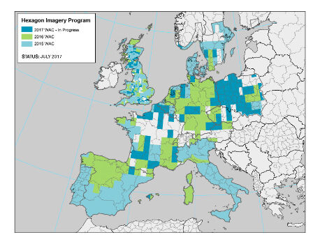
15th August 2017
Hexagon announces updates to 2017 airborne imagery collection plans15th August 2017
Yotta targets Latin American and North African market15th August 2017
Gold Sponsor of 17th International Scientific and Technical Conference10th August 2017
GeoSLAM Unveils Predictions For Engineering's Digital Future10th August 2017
Metering infrastructure connectivity in remote areas solved10th August 2017
Planners Can Earn Ample CM Credits At URISA Conferences