
Esri Maps Highlight Holiday Traffic around Major Airports
19th December 2017
Esri Maps Highlight Holiday Traffic around Major Airports
19th December 2017
Esri Maps Highlight Holiday Traffic around Major Airports19th December 2017
Landmark Information secures Met Office digital contract
15th December 2017
GeoSLAM Celebrates 5 Years In Business With New HQ & Record Growth
14th December 2017
Esri Maps Highlight Net Neutrality Implications14th December 2017
Caliper Corporation (Maptitude, TransCAD) Joins the USGS Coalition14th December 2017
Orbit GT and Mena 3D, Germany, sign Reseller Agreement
12th December 2017
New Version of Trimble eCognition Suite available
7th December 2017
CGG Releases Multi-Client Airborne GravMag Survey
6th December 2017
Avenza Maps iOS App Launches In The GEOINT App Store2nd December 2017
Landmark hosts digital mapping and data workshops
2nd December 2017
Canadian Company Timbercraft Consultation Chooses SuperPad
1st December 2017
Learn More About Maptitude for Redistricting
30th November 2017
thinkWhere Maps Out Business Expansion with Mahon Fitzgerald28th November 2017
Lido/mPilot 3.0: First step towards fully dynamic navigation maps27th November 2017
ABB selects Digpro’s dpPower for a large SCADA ADMS project in Turkey24th November 2017
Landmark Solutions launches ‘Points of Interest – Northern Ireland’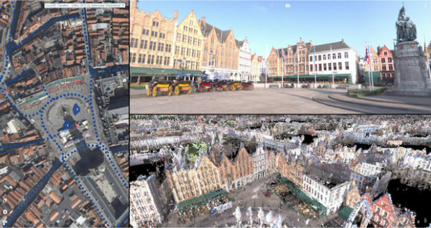
23rd November 2017
Orbit GT releases 3D Mapping Publisher v18

21st November 2017
Free U.S. Traffic Count Data for Use with Maptitude Mapping Software
16th November 2017
Autodesk and Esri Team to Advance Infrastructure Planning and Design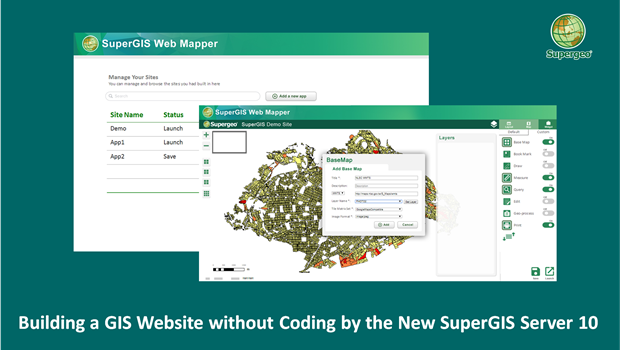
15th November 2017
Building a Unique GIS Website without Coding by Brand New SuperGIS Server 10
15th November 2017
Making a Giant Leap Toward Smart Irrigation with SuperGIS14th November 2017
Esri and Mobileye to Bring Real-Time Sensor Data to Public Transit
14th November 2017
Golden Software Releases Surfer® 2D and 3D14th November 2017
Avenza Releases MAPublisher 10 For Adobe Illustrator14th November 2017
Safe City Framework Unveiled at Smart City World Congress14th November 2017
CACI Boosts Location Planning Services with Mapmechanics Acquisition14th November 2017
Landmark's major relaunch of MAGIC interactive GB mapping service
14th November 2017
thinkWhere Powers Humanitarian Disaster Response with OpenStreetMap Tool7th November 2017
ADC WorldMap Releases Digital Atlas Version 7.43rd November 2017
Oxfordshire County Council looks to GIS to transform service delivery2nd November 2017
Pitney Bowes and Arrow Electronics sign Agreement
31st October 2017
Sefton Council uses GIS to support ‘One Council’ policy

30th October 2017
Helping Councils get the Most from Infrastructure Asset Management
26th October 2017
CGG Awarded Contract for Licenses in Côte d’Ivoire
26th October 2017
Orbit GT updates 3D Mapping Cloud with great new UAV support
24th October 2017
VSTEP provide CAE with bridge simulators for UAE Naval Training Centre
23rd October 2017
Jack Dangermond to Discuss Earth Observations at GEO Week
23rd October 2017
Ian MacLeod receives SEG Cecil Green Enterprise Award21st October 2017
Hexagon Supports Zurich’s Public Transportation Network
20th October 2017
Maintenance of the utility networks with Mobile Mapping technology18th October 2017
Enhanced and Improved Functionalities for New Release of Global Mapper
17th October 2017
Cloud migration path for Cadcorp web mapping