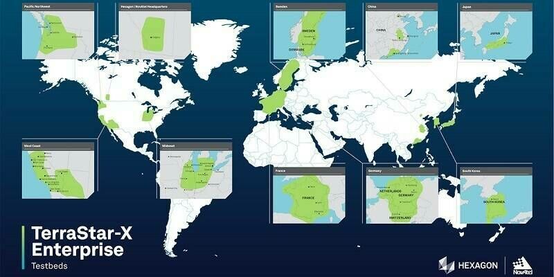
Hexagon expands TerraStar-X precise positioning GNSS correction service to South Korea
5th October 2023
Hexagon expands TerraStar-X precise positioning GNSS correction service to South KoreaNews as it happens! Keep in touch with the latest developments in business and technology in the regions or worldwide.
5th October 2023
Hexagon expands TerraStar-X precise positioning GNSS correction service to South Korea
5th October 2023
Austro Control Dronespace: drone traffic management system for Austria is ready for takeoff
4th October 2023
Richard Evans Appointed to Role of Sales Consultant at Bluesky International
4th October 2023
Trimble receives Merit Award for Technology Innovation

3rd October 2023
Aeronautics Announces new contracts in excess of $60M from numerous international customers
3rd October 2023
GMV takes another step in the provision of positioning technology for automated driving
2nd October 2023
Intergeo Innovations Award 2023: Vote For The Ultimate Terrestrial Laser Scanner, Riegl VZ-600i
2nd October 2023
Infrastructure Projects in Europe, Middle East, and Africa Named as Finalists in Bentley Systems’ 2023 Going Digital Awards in Infrastructure
28th September 2023
Significant growth and scale for the Mining and Metals Central Asia and Kazcomak 2023 exposition
28th September 2023
Emlid released Reach RS3 GNSS receiver with tilt compensation
27th September 2023
Mappedin Empowers Communities to Map Every Building With Game-Changing App
27th September 2023
Trimble and Kyivstar Partner to Provide GNSS Correction Services for Geospatial, Agriculture and Construction Applications in Ukraine
26th September 2023
Estonia revolutionises drone flying as FREQUENTIS state-of-the-art UTM suite is put into operation
26th September 2023
IDS GeoRadar launches Chaser XR ground-penetrating radar
25th September 2023
Fugro supports coastal resilience in Florida with new seafloor mapping contract
25th September 2023
Virtual Surveyor Unveils Photogrammetry App in Major New Release of Smart Drone Survey Software
22nd September 2023
First large-scale onshore nodal CCS exploration projects in Brazil commence
22nd September 2023
New Trimble GNSS Receiver with Trimble ProPoint Delivers Survey Precision and Productivity in the Field
21st September 2023
Norway to transform emergency medical communications with FREQUENTIS
21st September 2023
Naurt supercharges delivery industry as it goes public with innovative geo-location software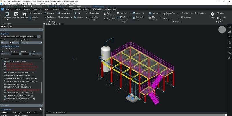
20th September 2023
Hexagon Announces the Release of CADWorx 23 Plant Design Suite
20th September 2023
Fugro provides geotechnical expertise for clean fuel project in Louisiana
19th September 2023
Localized Distribution, the new PointPerfect feature that reduces bandwidth up to 70%