
Satellite Imaging
Don't miss a beat, sign up to our newsletter
SimActive Used for Coastal Erosion Assessment with UAVs
17th January 2017
SimActive Used for Coastal Erosion Assessment with UAVsexactEarth Adds 4 Payloads to Second Generation Constellation
16th January 2017
exactEarth Adds 4 Payloads to Second Generation Constellation
Successful Initial Launch for Second Generation Real-Time Constellation
16th January 2017
Successful Initial Launch for Second Generation Real-Time ConstellationAirbus Defence and Space ships SES-10 telecom satellite to launch site
16th January 2017
Airbus Defence and Space ships SES-10 telecom satellite to launch site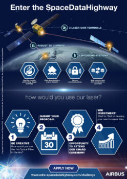
Airbus Launches “Enter the SpaceDataHighway” Challenge
12th January 2017
Airbus Launches “Enter the SpaceDataHighway” Challenge
Collaboration with Deimos Imaging to Support the PanGeo Alliance
11th January 2017
Collaboration with Deimos Imaging to Support the PanGeo Alliance
Whitepaper - The Future of Geospatial Imagery Collection Analysis Exploitation & Exchange
10th January 2017
Whitepaper - The Future of Geospatial Imagery Collection Analysis Exploitation & Exchange
Ecometrica secures breakthrough £14.2m UK Space Agency contract
9th January 2017
Ecometrica secures breakthrough £14.2m UK Space Agency contract
BARSC Welcomes the Satellite Applications Catapult as New Member
9th January 2017
BARSC Welcomes the Satellite Applications Catapult as New Member
Southern Hemisphere Space Program to tackle the final frontier
6th January 2017
Southern Hemisphere Space Program to tackle the final frontier
Earth-i has Quality at the Heart of Operations
5th January 2017
Earth-i has Quality at the Heart of Operations
Collaboration on Miniature Hyperspectral Ultraspectral Camera System
28th December 2016
Collaboration on Miniature Hyperspectral Ultraspectral Camera System
DigitalGlobe Releases “20 Iconic Satellite Images from 2016” Gallery
23rd December 2016
DigitalGlobe Releases “20 Iconic Satellite Images from 2016” Gallery
exactEarth Awarded Project with UK Space Agency
22nd December 2016
exactEarth Awarded Project with UK Space Agency
exactEarth to Provide India's Navy with Satellite AIS
21st December 2016
exactEarth to Provide India's Navy with Satellite AIS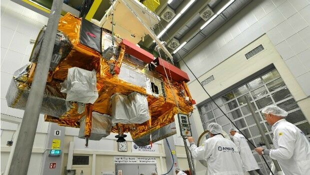
Revised Global Mapper Training Curriculum and Schedule for 2017
21st December 2016
Revised Global Mapper Training Curriculum and Schedule for 2017First test flights for air traffic modernisation project, completed
20th December 2016
First test flights for air traffic modernisation project, completed
Copernicus Sentinel-3 Marine Data flow to users in Africa
19th December 2016
Copernicus Sentinel-3 Marine Data flow to users in Africa
Five Years of the First Pléiades Satellite Launch Celebrated
19th December 2016
Five Years of the First Pléiades Satellite Launch Celebrated

Major contract award from the Government of Queensland, Australia
15th December 2016
Major contract award from the Government of Queensland, Australia
GAF, GeoVille, SIRS and e-GEOS contracted by the EEA
14th December 2016
GAF, GeoVille, SIRS and e-GEOS contracted by the EEA
New Zealand Earthquake sees deployment of Fugro’s Airborne Technology
7th December 2016
New Zealand Earthquake sees deployment of Fugro’s Airborne Technology
Globalstar Helped Natural History Unit Film Wildlife Migrations
7th December 2016
Globalstar Helped Natural History Unit Film Wildlife Migrations
AERO-SATCOM agreement with Inmarsat’s Global Government Business Unit
6th December 2016
AERO-SATCOM agreement with Inmarsat’s Global Government Business Unit
“Farmstar” Enriches its Offer With New Recommendations
5th December 2016
“Farmstar” Enriches its Offer With New Recommendations
DigitalGlobe Releases First Image from WorldView-4 Satellite
3rd December 2016
DigitalGlobe Releases First Image from WorldView-4 Satellite
Scientists’ weather predictions stop farmers losing crop
2nd December 2016
Scientists’ weather predictions stop farmers losing crop
Satellite Imagery: Gatlinburg, Tennessee Wildfire
2nd December 2016
Satellite Imagery: Gatlinburg, Tennessee Wildfire
Globalstar’s SPOT Gen3 chosen to Safeguard Workers in EMEA and Asia
30th November 2016
Globalstar’s SPOT Gen3 chosen to Safeguard Workers in EMEA and Asia
LIDARUSA Chooses Global Mapper for Erosion Control
30th November 2016
LIDARUSA Chooses Global Mapper for Erosion Control
Uncommon Information and Technology Leaders Form Partnership
29th November 2016
Uncommon Information and Technology Leaders Form Partnership
Airbus Safran Launchers and Dassault Systèmes Collaborate for Ariane 6
29th November 2016
Airbus Safran Launchers and Dassault Systèmes Collaborate for Ariane 6
SimActive Enables Processing in the Cloud
29th November 2016
SimActive Enables Processing in the Cloud
Farmers and environment benefits as OS create new data layer of hedges
25th November 2016
Farmers and environment benefits as OS create new data layer of hedges
Shear brilliance: computing tackles the mystery of the dark universe
25th November 2016
Shear brilliance: computing tackles the mystery of the dark universe
EARSC and J-spacesystems sign memorandum of understanding
24th November 2016
EARSC and J-spacesystems sign memorandum of understanding
Start of service for Europe's SpaceDataHighway
23rd November 2016
Start of service for Europe's SpaceDataHighway
The SpaceDataHighway is Open for Traffic
23rd November 2016
The SpaceDataHighway is Open for Traffic
Second Edition of Commercial UAV Expo Hits it out of the Park
21st November 2016
Second Edition of Commercial UAV Expo Hits it out of the Park
NM Group purchase new Leica ALS80 LiDAR system
21st November 2016
NM Group purchase new Leica ALS80 LiDAR system
Martek Marine included on a ground breaking framework contract
21st November 2016
Martek Marine included on a ground breaking framework contract