
Topcon announces integrated mass data processing software
9th March 2017
Topcon announces integrated mass data processing softwareThe compilation, reproduction and dissemination of maps and charts by means of manual (analogue) or digital techniques, tools and workflows. This topic covers the compilation, reproduction, dissemination and use of both analogue (paper) and digital maps, charts and atlases. As well as the science of cartography, including georeferencing and geocoding, digital techniques for compiling and generating various types of raster and vector maps and charts are covered, as are the digital mapping tools and Geographic Information Systems available for this purpose. The application of cartography for aeronautical, terrestrial and marine purposes is also covered
9th March 2017
Topcon announces integrated mass data processing software9th March 2017
New 10-inch touchscreen display for construction machine control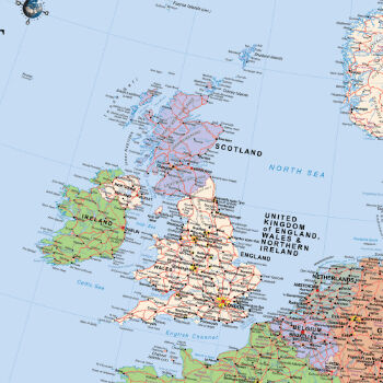
9th March 2017
Scottish / UK Post Brexit Maps Now Available on Avenza Maps9th March 2017
Common Object Model Container Standards Working Group9th March 2017
GeoXphere & Skyline collaboration accelerates 3D City Model production
9th March 2017
Geospatial mapping solution for New York Power Authority9th March 2017
GHGSat Satellite Deploys Headwall’s Micro-Hyperspec Imaging Sensor9th March 2017
Vector™ VR1000 Rugged GNSS Receiver for Machine Control Applications9th March 2017
OGC is seeking information on Geospatial APIs9th March 2017
Moving BI and GIS closer together thanks to GeoQlik9th March 2017
Hemisphere GNSS Introduces LandMetrix™ OEM Toolkit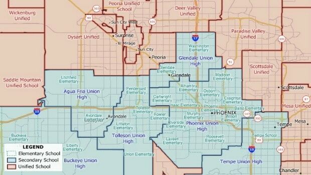
8th March 2017
New School District Data for Maptitude Mapping Software8th March 2017
Cadcorp Workload Modelling Analysis Service8th March 2017
Thales joins forces with Unifly to facilitate drone use8th March 2017
Intelsat General becomes Airbus channel partner8th March 2017
Intelligent Telematics to Demonstrate at Commercial Vehicle Show 20178th March 2017
Centrik Moves Into South Africa With Premier Aviation8th March 2017
TomTom selected by Volvo for Drive Me programme8th March 2017
Spirent Helps to Improve Search and Rescue Operations at Sea8th March 2017
PubNub CEO Todd Greene to Deliver Keynote Address at Esri DevSummit8th March 2017
Reality modelling software bundled with UAS software solutions8th March 2017
Swedish energy company E.ON has chosen Digpro8th March 2017
Maptek delivers innovative smaller lighter, faster laser scanner8th March 2017
Disaster Response for the Gulf Oil Spill Webinar8th March 2017
Dr Lucy Mason appointed Head of the Defence and Security Accelerator7th March 2017
Hemisphere GNSS Introduces GradeMetrix™ Software7th March 2017
Spirent Helps to Improve Search and Rescue Operations at Sea7th March 2017
GSSI Announces a New UtilityScan® GPR System7th March 2017
Hemisphere GNSS Introduces IronOne Rugged Display & Computer7th March 2017
HampsonRussell software donated to University of Texas7th March 2017
Garmin announces enhancements for G500H in R44 helicopter7th March 2017
HR Wallingford celebrates 70 years making waves7th March 2017
Current sales management trends and practices7th March 2017
TomTom Navigation Components for Next Generation Peugeots7th March 2017
6 essentials for a machine control GPS receiver7th March 2017
TomTom Celebrates Millionth Mercedes-Benz Car with TomTom Traffic7th March 2017
Masternaut launches fuel card in partnership with AllStar7th March 2017
Virtual Reality: Huge Investment Support Accelerates Innovations