
Cartography
The compilation, reproduction and dissemination of maps and charts by means of manual (analogue) or digital techniques, tools and workflows. This topic covers the compilation, reproduction, dissemination and use of both analogue (paper) and digital maps, charts and atlases. As well as the science of cartography, including georeferencing and geocoding, digital techniques for compiling and generating various types of raster and vector maps and charts are covered, as are the digital mapping tools and Geographic Information Systems available for this purpose. The application of cartography for aeronautical, terrestrial and marine purposes is also covered
Location Powers Workshop to advance Big Data Geospatial applications
18th August 2016
Location Powers Workshop to advance Big Data Geospatial applications
AVEVANET Gateway Achieves Certified Integration with SAP® ERP
18th August 2016
AVEVANET Gateway Achieves Certified Integration with SAP® ERP
Location app ‘Wave’ seeks £500,000 investment from Crowdcube to launch in the UK
18th August 2016
Location app ‘Wave’ seeks £500,000 investment from Crowdcube to launch in the UK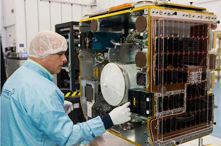
senseFly & Air Nav Pro join forces to reduce mid-air collisions
18th August 2016
senseFly & Air Nav Pro join forces to reduce mid-air collisions
Laser scan coordinate system tools released in Maptek I-Site Studio
18th August 2016
Laser scan coordinate system tools released in Maptek I-Site Studio
Oil and gas industry is undergoing a digital transformation
17th August 2016
Oil and gas industry is undergoing a digital transformation
Seafloor’s In-Water Demonstration At Oceans ’16
17th August 2016
Seafloor’s In-Water Demonstration At Oceans ’16
exactEarth Announces Small Vessel Tracking Contract
17th August 2016
exactEarth Announces Small Vessel Tracking Contract
Avenza Releases MAPublisher 9.8 for Adobe Illustrator
16th August 2016
Avenza Releases MAPublisher 9.8 for Adobe Illustrator
The Latest Ehang Ghost Drone 2.0 Available From DronesDirect.CO.UK
16th August 2016
The Latest Ehang Ghost Drone 2.0 Available From DronesDirect.CO.UK
Fugro Supports Total Ultra-Deep Water Drilling Campaign
16th August 2016
Fugro Supports Total Ultra-Deep Water Drilling Campaign
Airbus D&S Celebrates Seven Years of Multispectral Imaging from UK-DMC
16th August 2016
Airbus D&S Celebrates Seven Years of Multispectral Imaging from UK-DMC
InterDrone After-Hours Sessions Added to Largest Commercial UAV Show
16th August 2016
InterDrone After-Hours Sessions Added to Largest Commercial UAV Show
HERE appoints Angel L. Mendez as Chief Operating Officer
16th August 2016
HERE appoints Angel L. Mendez as Chief Operating Officer
Introducing Improved Mine Scheduling Software
16th August 2016
Introducing Improved Mine Scheduling Software
HERE appoints Peter Kürpick as Chief Platform Officer
16th August 2016
HERE appoints Peter Kürpick as Chief Platform Officer
New Esri Training website set to launch in August
15th August 2016
New Esri Training website set to launch in August
4DMapper; the secret behind sharing geodata
15th August 2016
4DMapper; the secret behind sharing geodata
GGP Systems partners with Blackpool Council
13th August 2016
GGP Systems partners with Blackpool Council
East View Signs Historic POD Contract with SEMAR
13th August 2016
East View Signs Historic POD Contract with SEMAR
European Space Imaging announces new partnership with Vricon
12th August 2016
European Space Imaging announces new partnership with Vricon
Global Mapper Chosen for Coastal Mapping Project
12th August 2016
Global Mapper Chosen for Coastal Mapping Project
PCI Geomatics Releases Geomatica 2016 Service Pack 1
12th August 2016
PCI Geomatics Releases Geomatica 2016 Service Pack 1KNect365 Maritime launches Shipping2030 Asia
12th August 2016
KNect365 Maritime launches Shipping2030 AsiaBristow & Sutor Installs GreenRoad Solution
12th August 2016
Bristow & Sutor Installs GreenRoad Solution
GIS Technology Proves Fundamental in Battle against Zika Virus
12th August 2016
GIS Technology Proves Fundamental in Battle against Zika Virus
Impressive Speaker Line-Up for Luciad INTERACT
11th August 2016
Impressive Speaker Line-Up for Luciad INTERACT
Critical Infrastructure Protection & Resilience Asia
11th August 2016
Critical Infrastructure Protection & Resilience Asia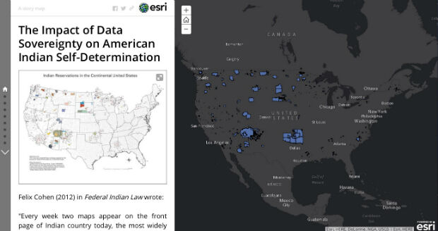
ABPmer to help with decisions at aquaculture and fisheries R&D centre
10th August 2016
ABPmer to help with decisions at aquaculture and fisheries R&D centre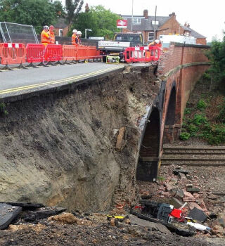
Barrow Upon Soar Rail Closure Prompts Monitoring Calls
10th August 2016
Barrow Upon Soar Rail Closure Prompts Monitoring Calls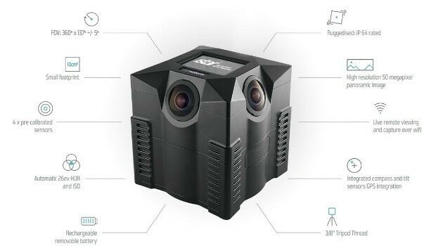
iSTAR 360 degree Measurement Module integrated by imaging companies
10th August 2016
iSTAR 360 degree Measurement Module integrated by imaging companies
MICROMINE's latest feature on Implicit Modelling
10th August 2016
MICROMINE's latest feature on Implicit Modelling.jpg)
Fugro Specialists bring Expertise to Industry Roles
9th August 2016
Fugro Specialists bring Expertise to Industry Roles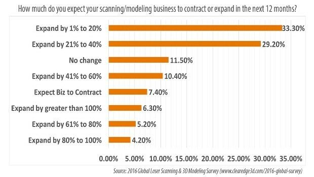
78.7% of AEC Firms Expect Scanning/Modeling Work to Increase
9th August 2016
78.7% of AEC Firms Expect Scanning/Modeling Work to Increase
OGC adopts SensorThings API Part 1: Sensing Standard
9th August 2016
OGC adopts SensorThings API Part 1: Sensing Standard
indoo.rs revolutionizing the Indoor Positioning industry
9th August 2016
indoo.rs revolutionizing the Indoor Positioning industry
Fugro to Showcase Structural Integrity Services
9th August 2016
Fugro to Showcase Structural Integrity Services