
3D Repo Launch BIM Platform with Integrated VR at National Infrastructure Forum
31st May 2017
3D Repo Launch BIM Platform with Integrated VR at National Infrastructure Forum
31st May 2017
3D Repo Launch BIM Platform with Integrated VR at National Infrastructure Forum
30th May 2017
3D Repo Joins UK Government’s G-Cloud Digital Marketplace25th May 2017
Open data – engine for innovation or simply hot air?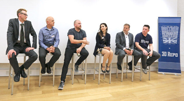
18th May 2017
Third British Information Modelling Event Wins Praise from Delegates8th May 2017
OGC invite to Environmental Linked Feature Interoperability Experiment24th April 2017
Reminder for the Open Data Questionnaire by 30 April please!19th April 2017
OGC seeks comment on proposed GeoScience Domain Working Group19th April 2017
Blue Marble Releases Geographic Calculator 20175th April 2017
OGC appoints Dr. Luis Bermudez to head OGC Innovation Program29th March 2017
OGC requests public comment on proposed GeoRSS Community Standard23rd March 2017
Public comment on proposed Indexed 3D Scene Layers (I3S) Community
22nd March 2017
3D Repo Brings Cloud Expertise to Government Funded Smart Infrastructure Project15th March 2017
OGC approves new standard for geological science data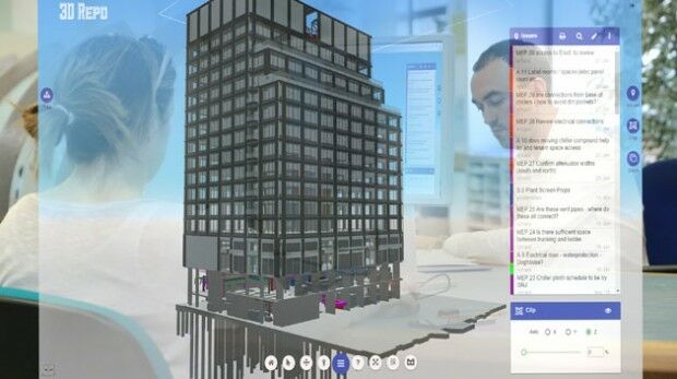
14th March 2017
OGC announces kickoff of major innovation testbed – Testbed 113th March 2017
OGC publishes Moving Features Access specification10th March 2017
Comment on proposed Unmanned Systems Domain Working Group9th March 2017
Common Object Model Container Standards Working Group9th March 2017
OGC is seeking information on Geospatial APIs
1st March 2017
3D Repo wins European funding for cyber security system research23rd February 2017
OGC invites you to the Arctic Spatial Data Pilot demonstration22nd February 2017
AddressBase Toolkit for Mapinfo Released By Aligned Assets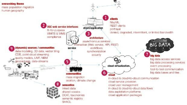
16th February 2017
Data and services for Testbed 13’s mass migration scenario

14th February 2017
3D Repo Appoints Andrew Norrie as Commercial Director13th February 2017
OGC invites expertise on underground maps and models13th February 2017
URISA's GIS Hall of Fame Nominations Process Opens
10th February 2017
Ocean Business 2017 to host co-located Maritime Dual-use Events
10th February 2017
Skyline Software Systems Releases PhotoMesh 7.1
10th February 2017
Orbit GT releases Oblique Mapping and Feature Extraction v177th February 2017
Avenza Releases Geographic Imager 5.2 for Adobe Photoshop7th February 2017
Underground Infrastructure Data for phase 1 to be initiated6th February 2017
OGC Calls for Participation in Testbed 13 Part 2 ESA Threads3rd February 2017
OGC seeks public comment on candidate GeoPackage 1.2 standard1st February 2017
Location Powers event scaling linked data to big data26th January 2017
OGC Calls for Participation in Major Innovation Testbed (Testbed 13)
20th January 2017
Daniel Behnke Named URISA Young Professional of the Year19th January 2017
URISA 2017 Exemplary Systems in Government Awards Process Opens18th January 2017
OGC seeks public comment on OGC WaterML 2 - Part 317th January 2017
OGC seeks public comment on candidate InfraGML encoding standards10th January 2017
The FME World Tour is Coming to the UK, Australia & Singapore in 20174th January 2017
MAPublisher now integrates ArcGIS Online within Adobe Illustrator27th December 2016
OGC Calls for Participation in its Indian Interoperability Plugfest6th December 2016
OGC requests public comment on its Coverage Implementation Schema