WiBotic Announces a Wireless Power System for DJI Matrice 200 Series Drones
29th August 2018
WiBotic Announces a Wireless Power System for DJI Matrice 200 Series DronesTechnologies that provide tracking and navigational functions for unmanned, autonomous and semi-autonomous vehicles on land, at sea and in the air, and use cases on their practical deployment
This topic covers the technologies that provide tracking and navigational functions for unmanned vehicles of all types, on land, at sea and in the air. These technologies include satellite-based navigation (GNSS) receivers, Inertial Navigation Systems (INS), Acoustic Positioning Systems (APS) and other sensors for situational awareness (radars, Lidars, optical and infrared cameras, ultrasonic, etc). Use cases for the deployment of these technologies in unmanned vehicles embraces land surveying, construction and urban planning, underwater exploration and asset management, archaeological and heritage studies, environmental monitoring, conservation, utility surveys, insurance risk surveys, built infrastructure surveys and inspection, defence applications, open cast mining, forestry and agriculture, traffic management, emergency services, search and rescue, humanitarian support, disease control and healthcare, merchandise delivery and weather forecasting
29th August 2018
WiBotic Announces a Wireless Power System for DJI Matrice 200 Series Drones29th August 2018
Answers to the questions on the new general aviation regulation29th August 2018
ClassNK adds to RIMS portfolio of class approvals28th August 2018
Commercial UAV Expo Is Hosting “Beyond The Cage” Demonstrations28th August 2018
Phase One Industrial Launches 150MP Metric Camera24th August 2018
The future of taxi drones at the FAI International Drone Conference and Expo16th August 2018
Drone Major Group invests in SUAS Global expansion15th August 2018
Martek Announce New Head of Counter-Drone Technology M.A.DS
17th July 2018
Aeronyde and Unifly Partner to Build Advanced Drone Systems12th July 2018
Elbit Systems Rolls-out Hermes 900 StarLiner
11th July 2018
Virtual Surveyor Streamlines Workflow, Enhances User Experience
3rd July 2018
Next-generation mapping drone raises capital for further expansion
2nd July 2018
Headwall Appoints Christopher Calling to Board of Directors25th June 2018
“Forecasts for drones are wrong” says leading British drone expert
19th June 2018
ObliMapper Transforming Drone Imagery into Actionable Visual Intelligence18th June 2018
CGG’s Helitem Shatters AEM Low-Frequency Barrier18th June 2018
Inaugural European Drone Summit in Frankfurt16th June 2018
Expanded Focus on Drones in Public Safety at InterDrone12th June 2018
Headwall Integrates Hyperspectral and LiDAR Aboard UAV Platforms12th June 2018
SimActive Software for Precision Agriculture in Brazil11th June 2018
Huawei and Unifly Collaborate to Identify and Track Drone Flights10th June 2018
AP-Flyer is the Latest Sponsor of UAV Technology Conference8th June 2018
Pix4D launches its first fully dedicated product for agriculture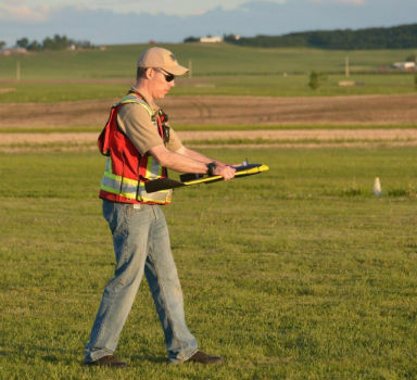
22nd May 2018
Expanded Enterprise Focus at Largest Commercial Drone Show in USA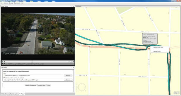
16th May 2018
Remote GeoSystems Releases All-New Video GeoTagger8th May 2018
Unifly supports UNICEF's humanitarian drone corridor4th May 2018
Septentrio supplies AsteRx-m2 for Delair UX11 large-area mapping UAV4th May 2018
QuestUAV Closes deal to Map World’s Largest Construction Project4th May 2018
ISPS Code Fails To Contemplate Aerial Threats From Drones2nd May 2018
New Rugged Atlas®-Capable UAV GNSS Antenna from Hemispere GNSS30th April 2018
Phase One Industrial Innovates UAV-based Aerial Imagery27th April 2018
QuestUAV showcasing on BBC One’s Countryfile26th April 2018
Delair Announces Availability of UAV for Geospatial Professionals26th April 2018
Captains of industry accept position in Unifly advisory board24th April 2018
Wingtra launches a drone that sets a new benchmark in photogrammetry20th April 2018
The UAV sector is becoming more professional19th April 2018
Discover the most powerful surveying software17th April 2018
Quickly Assess your UAV Data Quality in the field17th April 2018
Second Annual Commercial UAV Expo Europe a Huge Success
12th April 2018
senseFly announces the appointment of new CEO, Gilles Labossière5th April 2018
Inaugural European Drone Summit in Frankfurt
3rd April 2018
senseFly and Trimble optimize workflow for geospatial drone operators