
SpaceDataHighway starts full Copernicus service
19th March 2018
SpaceDataHighway starts full Copernicus serviceNews as it happens! Keep in touch with the latest developments in business and technology in the regions or worldwide.
19th March 2018
SpaceDataHighway starts full Copernicus service
19th March 2018
Supergeo Strengthens the Partnership with RASA Surveying16th March 2018
Developing a new tool to optimise sea wall design16th March 2018
Safe & The City Launches App To Combat Sexual Harassment In Public
16th March 2018
Aquabotix Announces Sale of Hybrid Vehicle to KIGAM
16th March 2018
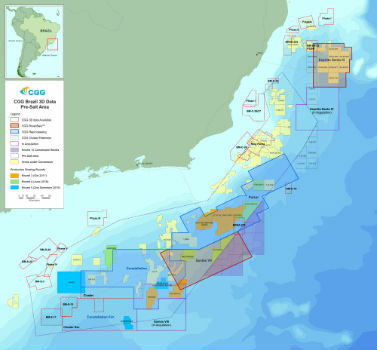
CGG Adds New Santos VIII Multi-Client Survey
16th March 2018
Tersus Takes New Stride into Surveying with David GNSS Receiver16th March 2018
Airbus launches photonics payload technology project – OPTIMA
15th March 2018
CSA Engineer to be Honored at Australasian Oil and Gas Conference
15th March 2018
Bluesky National Tree Map Helps Tamworth Council Bloom15th March 2018
Look who's talking at GeoDATA Ireland Showcase 2018
15th March 2018
University of Oldenburg Deploys Globalstar Satellite Technology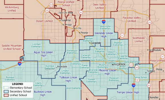
14th March 2018
New 2018 School District Data for Maptitude Mapping Software

14th March 2018
Hemisphere GNSS New Atlas®-Capable Vector™ V1000 GNSS Receiver

13th March 2018
4 weeks until Commercial UAV Expo Europe, 3 days to save.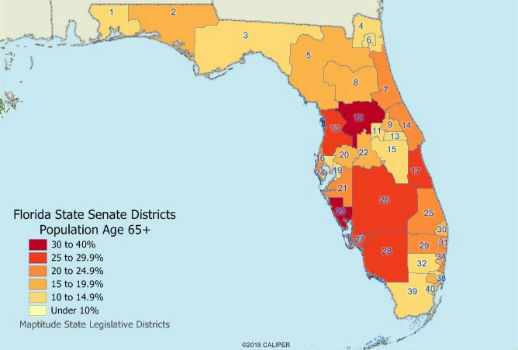
13th March 2018
Maptitude 2018 USA Legislative and Congressional Districts
13th March 2018
Septentrio announces special version of AsteRx-U MARINE receiver13th March 2018
Septentrio introduces SECORX-60 correction service12th March 2018
Jean-François Delepau named as new chairman of the Sofradir Group