
Teledyne CARIS and UK Hydrographic Office Partner to Transform Hydrographic Processing and Nautical Charting
25th July 2025
Teledyne CARIS and UK Hydrographic Office Partner to Transform Hydrographic Processing and Nautical ChartingNews as it happens! Keep in touch with the latest developments in business and technology in the regions or worldwide.
25th July 2025
Teledyne CARIS and UK Hydrographic Office Partner to Transform Hydrographic Processing and Nautical Charting
25th July 2025
Leica Geosystems makes reality capture easier to adopt with a new, all-in-one solution
24th July 2025
New Partnership Between Pix4D and UgCS Empowers Professionals with Smarter Mission Planning
24th July 2025
Swift Navigation Secures $50M Series E to Accelerate Global Adoption of Centimeter-Accurate Satellite Positioning
23rd July 2025
InnovizSMART Integrates NVIDIA Jetson Orin for Advanced Edge Computing
23rd July 2025
Exodigo Brings AI Efficiency to Infrastructure Industry, Closes $96 Million Series B
22nd July 2025
Commercial UAV Expo Announces Public Safety Summit Presented by AIRT
22nd July 2025
The Offshore Energy & Equipment Global Exhibition (OEEG) Launches Grandly
22nd July 2025
GMV to Develop Next-Generation Collision Avoidance Service for LEO Constellations through ESA ARTES support
22nd July 2025
Trimble and KT Corporation to Deliver Bundled Telecom and Precise Positioning Services in South Korea
21st July 2025
Spexi Expands Orthomosaic Coverage with 1M+ Acre Initiative
21st July 2025
EUMETSAT takes control of Europe’s first geostationary sounder
18th July 2025
UNIVITY signs the Zero Debris Charter and reaffirms its commitment to sustainable, responsible and sovereign space connectivity
18th July 2025
Astroscale U.S. Signs Space Act Agreement with NASA to Advance National Security On-Orbit Servicing Capabilities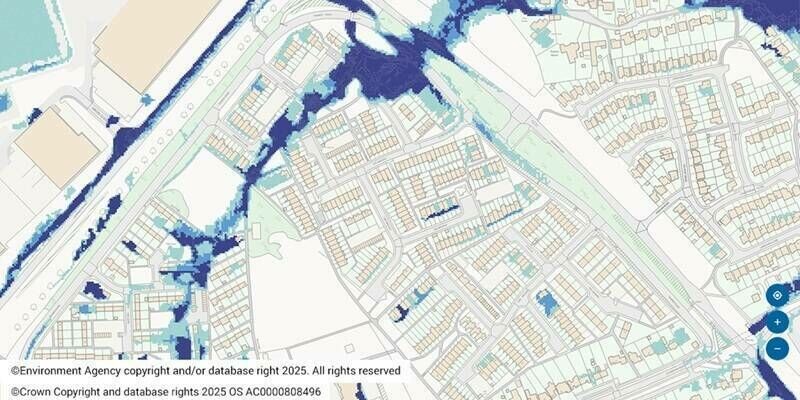
17th July 2025
Futures Housing Group employs spatial analysis for flood risk project
17th July 2025
SouthPAN satellite navigation program successfully passes Critical Design Review milestone
16th July 2025
Esri’s ArcGIS Basemaps Power Dataminr First Alert for Enhanced Real-Time Event Detection and Awareness
16th July 2025
Drone Harmony and Pix4D announce strategic partnership to enhance drone mission planning workflows
15th July 2025
Septentrio strengthens Agnostic Corrections Program with onocoy
15th July 2025
Celestia UK starts building world’s first Ka-band multi-beam gateway
15th July 2025
Fugro and Esri collaborate to advance climate resilience
15th July 2025
Esri Collaborates with Microsoft to Bring ArcGIS Users New AI Enhancements
11th July 2025
Neo Space Group Completes Acquisition of UP42 from Airbus Defence and Space
11th July 2025
Airbus awarded Hisdesat contract to build PAZ-2 satellites reinforcing Spain's sovereign space capability