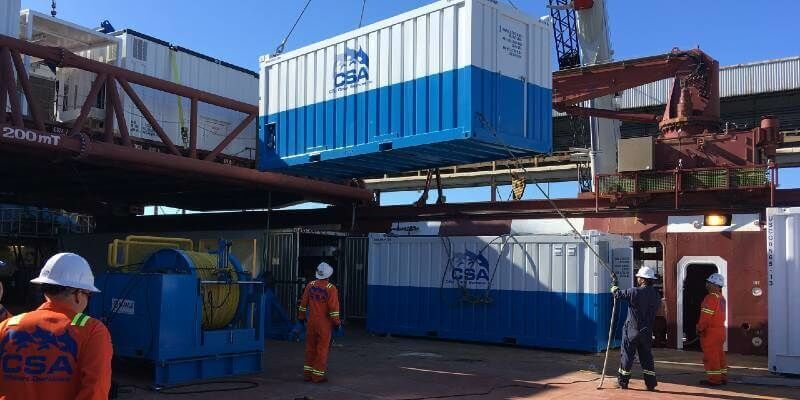
CSA Ocean Sciences Completes Multidisciplinary Telecom Cable Route Survey
5th November 2021
CSA Ocean Sciences Completes Multidisciplinary Telecom Cable Route SurveyNews as it happens! Keep in touch with the latest developments in business and technology in the regions or worldwide.
5th November 2021
CSA Ocean Sciences Completes Multidisciplinary Telecom Cable Route Survey
5th November 2021
Soletanche Bachy Transforms Construction Site Safety Management with SimplyVideo5th November 2021
State-of-the-art software to catalogue space debris for the German Space Agency4th November 2021
TUNDRA drone integrated with UgCS Integrated Systems solutions4th November 2021
UP42 Unveils Very High-Resolution Imagery from Airbus Pléiades Neo Satellites4th November 2021
New mobile app turns any Android or IOS device into GPS tracker
3rd November 2021
Trimble and Microsoft Partner to Drive Digital Transformation Across Industries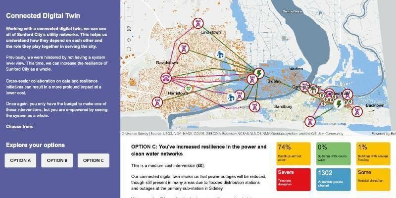
3rd November 2021
National Digital Twin programme launches interactive app and film at COP26
2nd November 2021
GeoCue and BayesMap Announce StripAlign for True View EVO
2nd November 2021
Keynote Lineup Announced For Geo Week 2022
1st November 2021
The Nippon Foundation-GEBCO Seabed 2030 Project Announces Partnership with TCarta
1st November 2021
Geo Week Award Ceremony Nominations Accepted Until Dec 1
28th October 2021
ADMIRALTY Small Craft Charts service launched by UKHO28th October 2021
NaviBlind leverages u-blox ZED-F9P high precision GNSS technology to empower the blind and visually impaired28th October 2021
SSC and Bradford ECAPS sign MoU regarding commercial orbital debris removal services
27th October 2021
The shortlist nominees for the 2021 IoT Global Awards are …27th October 2021
OneWeb and Tampnet sign agreement to further develop the next generation of offshore connectivity capabilities27th October 2021
Airbus, Air Liquide and ispace Europe launch EURO2MOON, a non-profit European platform to explore future uses of natural lunar resources
26th October 2021
Tannery discovery redraws map of Fountains Abbey
26th October 2021
Bentley Education Program Expands to Global Scope
26th October 2021
HERE launches Intelligent Speed Assistance map for automakers to comply with EU regulation
25th October 2021
Staffordshire County Council awards contract to Cadcorp for corporate GIS in the cloud
25th October 2021
New teaching resources help children learn about local impact of climate change