Share
In the quest to address climate change and reduce greenhouse gas emissions, detecting methane leaks – a potent contributor to global warming – has become increasingly vital. Researchers are harnessing the capabilities of cutting-edge satellite technology to monitor these leaks from space.

Methane is a powerful greenhouse gas and the second-largest contributor to climate warming after carbon dioxide. Even despite its shorter lifespan of about 10 years in the atmosphere, a tonne of methane can retain an astounding 30 times more heat than a tonne of carbon dioxide over the course of a century. This means that when it comes to warming our planet, methane is a potent player.
But here's the good news: because methane doesn't stick around as long as carbon dioxide, it provides us with an opportunity to take relatively swift climate action. If we reduce methane emissions, we can actually see a tangible reduction in global methane levels within just a decade. This, in turn, helps to mitigate the enhanced greenhouse effect.
Super-emitters
Now, let's talk about ‘super-emitters’. While methane emitters refer to any source of methane ranging from natural processes like wetlands or human activities such as agriculture, methane super-emitters release a disproportionately large amount of methane compared to other emitters.
These are typically found amongst industrial facilities, such as oil and gas operations, coal mines, or even landfills, that have equipment or infrastructure issues leading to significant methane leaks.
These super-emitters are the low-hanging fruits in our quest to cut emissions. Fixing these super-emitters doesn't require complex or expensive solutions. In many cases, relatively simple repairs can result in significant climate gains.
However, there's a challenge: we first need to identify these super-emitters. That way, we can target our efforts effectively and start making a difference in the fight against climate change.
Using machine learning for methane detection
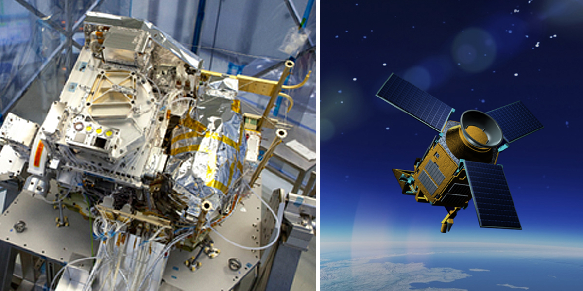
The Tropomi instrument onboard the Copernicus Sentinel-5P satellite is the only satellite instrument that produces a global map of methane concentrations every day.
The satellite measures methane by observing Earth's atmosphere and, specifically, the shortwave infrared bands. These bands are like unique fingerprints for methane, allowing Sentinel-5P to detect its presence with remarkable precision.
This wealth of data plays a critical role in our efforts to comprehend and address the consequences of methane emissions on our climate and environment, making it an indispensable tool in the battle against climate change.
Researchers from SRON Netherlands Institute for Space Research have announced a new algorithm that automatically discovers methane super-emitter plumes in Sentinel-5P data using machine learning.
It also automatically calculates the associated emissions based on the measured concentrations and concurrent wind speeds.
Berend Schuit from SRON explains, “Before, we manually identified the largest emitters, but it remains difficult to search through the millions of Tropomi pixels. A methane plume often only covers a few pixels. We now automatically get a list of detections from the machine learning model every day.
“We check those manually every week to make sure we are confident about the detections. What remains, dozens of methane plumes every week, we publish online. We communicate persistent leaks to other satellites with higher resolution so they can precisely identify the source.”
“This information is used by the United Nations' International Methane Emissions Observatory to find a solution together with the responsible companies or authorities.”
Co-author Bram Maasakkers, from SRON, added, “The dozens of methane plumes that Tropomi detects every week really present a golden opportunity in the fight against global warming.”
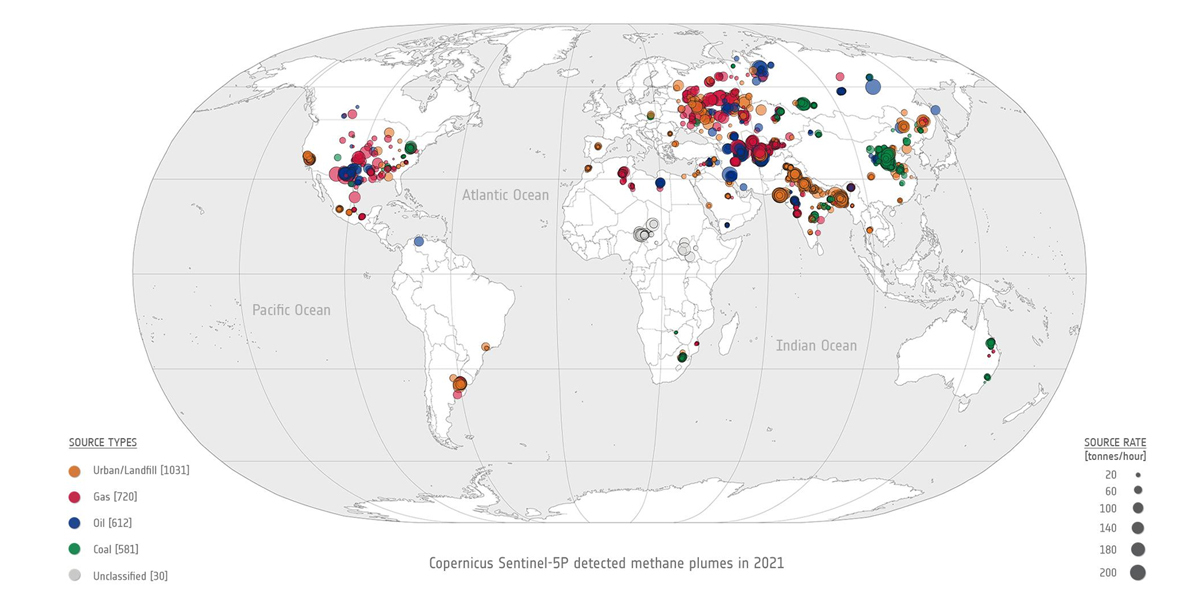
“If it’s visible from space, it is serious. For the first time, we now get a good global picture of these super-emitters. In our publication, we describe the 2974 plumes that we found in 2021; 45% originate from oil and gas facilities but we also see plumes from urban areas (35%) and coal mines (20%).
“We detect human-made emissions with a climate impact that is significantly larger than total greenhouse gas emissions of The Netherlands. In many cases, those leaks are easy to fix.”
The paper, published in the September 2023 issue of Atmospheric Chemistry and Physics, can be accessed by clicking here.
A three-tiered approach for methane detection
Typically, the detection of methane emissions relies on Copernicus Sentinel-5P. Until fairly recently, scientists have only begun harnessing the power of combining data from multiple satellites to monitor methane emissions from space which included the combined capabilities of Copernicus Sentinel-5P and Sentinel-2 satellites.
These high-tech space-based tools work in tandem to monitor and assess methane emissions on a global scale, allowing researchers to not only detect the presence of methane but also to localise and quantify emissions accurately.
With daily global coverage, Sentinel-5P is renowned for its high-precision methane measurements and can detect methane leaks anywhere on Earth. However, there’s a catch. The spatial resolution is relatively coarse, at 7x5.5 km. This means it can identify the presence of methane but not pinpoint its source with precision.
The Sentinel-2 satellites, on the other hand, are equipped with multi-band instruments that are not designed to observe methane concentrations but can identify precise locations of major methane leaks (emitting more than one tonne per hour) with a remarkable resolution of 20 m. But Sentinel-2 lacks daily global coverage, so it might miss out on capturing crucial data during certain emission periods.
But what about the Sentinel-3 mission? The satellites are equipped with multi-band radiometers that can observe shortwave infrared bands which are sensitive to methane concentrations. These satellites offer global coverage on a daily basis and a ground pixel resolution of 500 m.
In a recent paper published in Remote Sensing of Environment, researchers from SRON found that the Sentinel-3 satellites can retrieve methane enhancements from its shortwave infrared band measurements. Impressively, it can detect the largest methane leaks of at least 10 tonnes per hour, depending on factors like location and wind conditions, every single day. This puts it in a unique position to identify and monitor methane leaks.
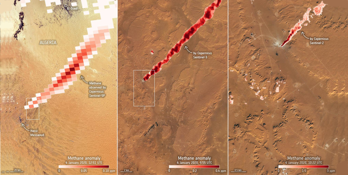
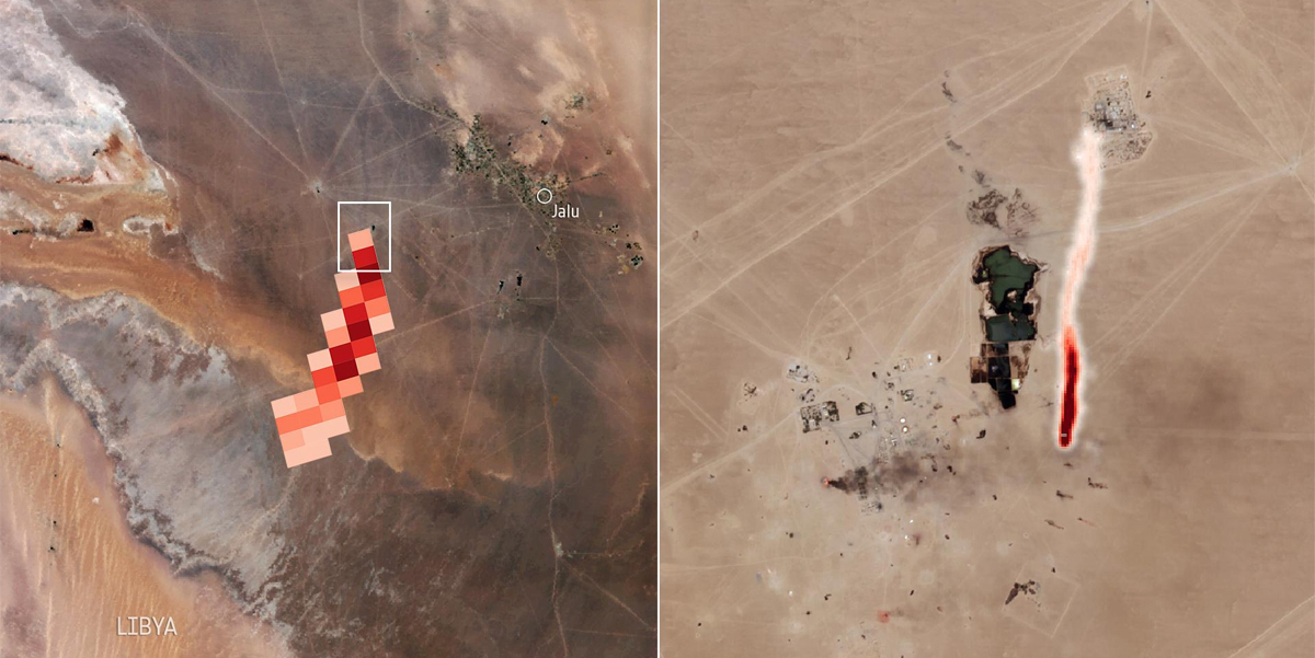
Near the Hassi Messaoud oil/gas field in Algeria, researchers from the SRON Netherlands Institute for Space Research identified a continuous methane emission from a leaking facility for six days. The methane plume, detected by Sentinel-5P over Algeria on 4 January 2020, extended for more than 200 km northeast.
The team used a Sentinel-2 image to zoom in on the plumes’ origins and pinpointed the exact location of the leak to be an oil/gas well, while Sentinel-3 showed the leak continued for six days.
In a recent paper published in Remote Sensing of Environment, researchers found that the Sentinel-3 satellites can retrieve methane enhancements from its shortwave infrared band measurements. Impressively, it can detect the largest methane leaks of at least 10 tonnes per hour, depending on factors like location and wind conditions, every single day. This puts it in a unique position to identify and monitor methane leaks.
When analysing these leaks, both Sentinel-2 and Sentinel-3 provided similar estimates of methane emissions – showcasing Sentinel-3’s utility in quantifying emissions. Combining the data from these two satellites allows researchers to zoom in with precision, identifying, quantifying and monitoring methane sources corresponding to plumes observed in Sentinel-5P’s global scans.
Sudhanshu Pandey, lead author and now scientist at NASA Jet Propulsion Laboratory, commented, “Who would have thought we can use three different Sentinel missions in a tiered approach to first spot methane super emitters from space globally with Tropomi on Sentinel-5P, then zooming in with Sentinel-3 and Sentinel-2, we’re able to identify the exact source responsible at facility level. This is the type of information we need to take swift action.”
In the fight against climate change, understanding and mitigating methane emissions are of paramount importance. Sentinel-3, with its unique combination of daily global coverage and high-resolution methane detection, emerges as a valuable asset in the arsenal of tools to track down and address these elusive leaks.
As technology advances and our understanding deepens, satellite observations will play a pivotal role in the global effort to combat climate change.
Article source: European Space Agency (https://www.esa.int/)
Subscribe to our newsletter
Stay updated on the latest technology, innovation product arrivals and exciting offers to your inbox.
Newsletter

