Share


Methane losses from leaks, venting, and operational inefficiencies pose a dual challenge: environmental impact and energy costs. While traditional satellite-based detection only spots the bigger emissions, Sean Donegan from Satelytics explains how GeoAI can enabled faster incident response and reduce the impact of smaller leaks before they became large-scale environmental disasters
Monitoring methane emissions is an ongoing challenge for energy producers. Inspection is plagued by limited visibility, delayed data access, and fragmented inspection methods. Recent advances in satellite imaging, artificial intelligence (AI), and cloud computing are giving energy companies new capabilities to identify even the smallest methane emissions.
AI-powered geospatial analytics (GeoAI) enables continuous monitoring of energy infrastructures at scale, including methane leak detection. GeoAI is proving its value in industries such as oil and gas, utilities, and water management, where assets are widespread and often located in hard-to-reach areas and is becoming a critical part of asset and risk management.
Controlling methane losses
Methane is both a valuable energy resource and a destructive greenhouse gas. Methane losses from leaks, venting, and operational inefficiencies pose a dual challenge: environmental impact and energy costs.
The US Environmental Protection Agency estimates that 1% of oil and gas produced leaks into the air (1) . Global estimates indicate that methane leaks and losses cost the oil and gas industry $16.6 billion in lost revenue annually. In the United States alone, operators incur annual losses from methane leaks exceeding $800 million (2). Gas utilities incur additional losses of $14.8 million to $342 million per year. That doesn’t include the estimated $9.3 billion (3) in yearly environmental damage.
Part of the problem is that traditional satellite-based detection only spots “superemitters,” the large methane leaks, and the majority of the small, chronic leaks remain undetected. It’s these smaller leaks that drain profits and contribute to greenhouse gases.
Conventional mentoring methods, such as manual inspections, aerial surveys, and lower resolution satellite imaging, don’t spot these low-volume emissions, partly because they operate on periodic schedules and because much of the infrastructure is in hard-to-reach places.
GeoAI is moving from pilots to practical applications
Geospatial analytics is proving increasingly valuable for leak detection by leveraging a wide range of information, including geographic, spatial, and location data, as well as high-resolution imagery. The newer geospatial analytics systems also use short-wave infrared (SWIR) data, along with contextual information such as terrain, infrastructure layouts, and historical patterns.
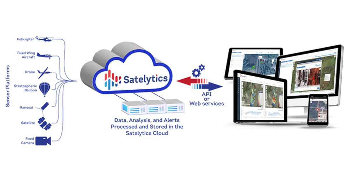
GeoAI is an enhanced approach to spatial analytics and represents the convergence of geospatial data and technology, such as AI (Machine Learning and Deep Learning) and scalable cloud computing for predictive modelling and other processes. GeoAI analyses massive amounts of geospatial data at speed and scale.
Unlike manual geospatial analytical models, GeoAI systems continuously process large volumes of data, identifying subtle changes that may indicate a potential leak.
Outputs are georeferenced into existing GIS environments so operators can visualise anomalies in relation to assets such as pipelines, wells, or compressor stations.
Access to real-time data transforms geospatial analytics from a retrospective tool into a leak detector, enabling immediate response to issues.
Why resolution and latency matter
Effectively using satellite imaging for methane detection requires high-resolution images and near-real-time data access.
Spatial resolution determines the level of detail in satellite images. Most satellite images are medium resolution, typically 30 by 30 metres (4), which can detect large methane plumes but lack the resolution to detect smaller leaks. High-resolution imaging of 30 centimetres or less can detect low-volume leaks with precise localisation.
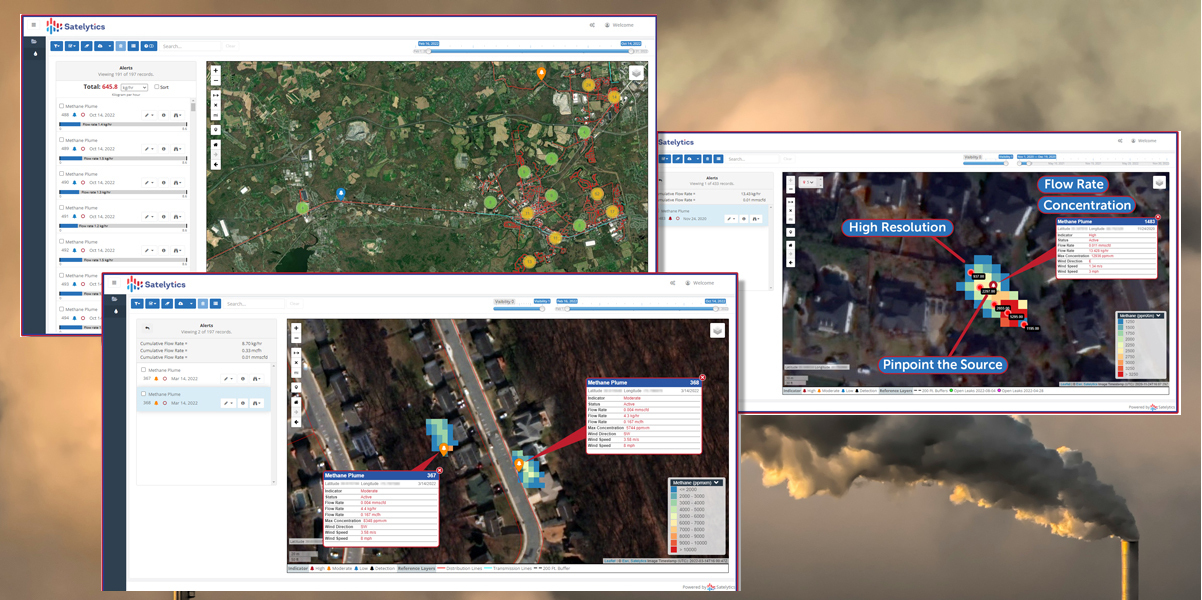
Latency is equally critical. The time between when the data is acquired and when it is processed for review can take days or weeks, during which time methane leaks continue to emit gases. Reducing latency to hours enables early detection and intervention, thereby reducing the severity of leaks.
With improvements in resolution and latency, we are seeing a shift from periodic inspections to continuous monitoring. With the aid of technology, energy providers are moving from a reactive strategy to a proactive approach to asset management.
Early detection in pipeline monitoring
The case of an oil and gas operator operating in North Dakota demonstrates the potential of GeoAI analytics.
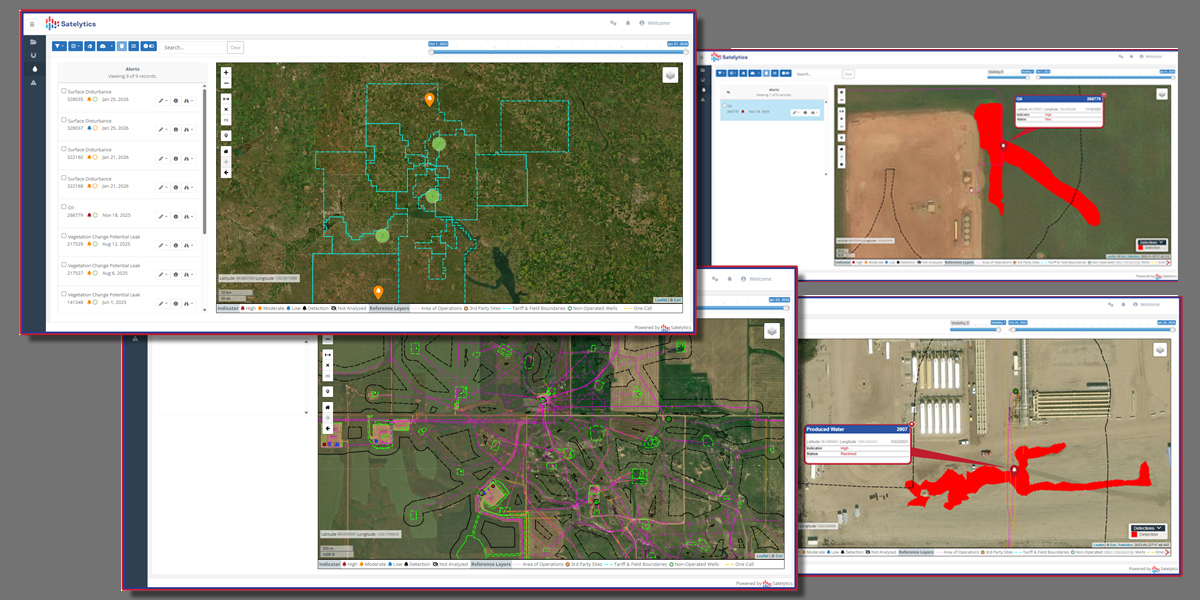
The oil and gas company experienced a produced water spill that leaked 34,000 barrels of wastewater for nearly a month before it was detected. Recognising that conventional monitoring was inadequate, the company implemented satellite monitoring and AI-powered analysis across the region, proactively identifying anomalies that could signal a leak or seepage.
Over time, the GeoAI system was able to detect smaller leaks at early stages. In fact, anomalies identified using satellite imagery later emerged as the initial point of detection in regulatory reports. For the first time, the company proactively detected potential problems. This monitoring project is now entering its fourth year of weekly operational status
Integrating geospatial analytics into operations enabled faster incident response and reduced the impact of leaks before they became large-scale environmental disasters. Proactive detection also made field inspection and repair more efficient, directing them to the exact location of a potential problem.
From compliance to profits
Monitoring for methane leaks has always been driven by regulatory compliance. Operators must meet requirements and report on all identified leaks and incidents.
GeoAI monitoring is increasingly becoming part of operators’ operational strategies. In addition to compliance reporting, proactive monitoring of infrastructure assets helps optimise production performance and minimise losses. For example, Duke Energy reports that it has reduced leaks by 85% (5) since 2022 using advanced leak detection technology.
There are tangible benefits as well. Reducing leaks and recapturing methane means fewer losses and more profits. Every metric ton of captured methane is worth $130 to $335 in recovered revenue.
How GeoAI Is transforming asset monitoring
Methane leak detection is only one proof -pointfor the power of GeoAI. The same technology is having a wide-ranging impact on other aspects of infrastructure monitoring.
The same analytics technology can be applied to liquid leak detection, ground movement, vegetation encroachment, and land-use changes. Utilities are using GeoAI to detect fuel spills, leaking water mains, and other problems. As technology continues to improve, new applications will emerge.
For example, advances in machine learning are distinguishing true emissions from background noise, thereby improving accuracy. Predictive models are continually refined using validation data and field inspections, thereby increasing accuracy and reducing false positives. Integrating GeoAI with enterprise GIS and asset management systems is creating more efficient workflows and enabling faster decision-making.
AI-powered geospatial analytics is revolutionising the detection and management of methane emissions, liquid leak detection, and other asset monitoring. By combining high-resolution satellite imagery with machine learning and cloud computing, GeoAI enables continuous monitoring of energy infrastructures with unprecedented speed and accuracy. The result is a move from reactive leak reporting to proactive leak detection, enabling data-driven asset management that saves time and money and reduces environmental risks.
References
(1). MIT Technology Review – The challenge of methane leaks
https://www.technologyreview.com/2024/03/13/1089725/methane-leaks-oil-gas/
(2). Satelytics – Watching $16 Billion Float Away
https://www.satelytics.com/resources/2025-watching-16-billion-float-away#:~:text=Methane%20leaks%2C%20seeps%2C%20and%20operational,profits%20and%20erode%20shareholder%20value
(3). Associated Press – US energy industry methane emissions are triple what government thins, study finds
https://apnews.com/article/methane-natural-gas-leak-climate-change-401cc08ad784d42fc463ed00bce4983e
(4). Research Gate - Landsat Satellite Imagery
https://www.researchgate.net/figure/a-Landsat-satellite-imagery-20-km-20-km-box-size-at-30-m-resolution-with-the-10-km_fig2_236238996
(5). Duke Energy – Duke Energy extends industry-leading methane monitoring to internstate natural gas assets with U.S. Department of Energy
https://news.duke-energy.com/releases/duke-energy-extends-industry-leading-methane-monitoring-to-interstate-natural-gas-assets-with-u-s-department-of-energy-funding#:~:text=Video:%20Learn%20more%20about%20Duke,and%20custmer%20natural%20gas%20assets.
Author: Sean Donegan is president and CEO of Satelytics based in Perrysburg, Ohio, USA. and is a specialist in geospatial analytics and infrastructure monitoring. He has extensive experience applying satellite data and AI to environmental and asset integrity challenges across energy and utility sectors.
Subscribe to our newsletter
Stay updated on the latest technology, innovation product arrivals and exciting offers to your inbox.
Newsletter