Share
Open, high-quality, interoperable base map data paired with stable, standardized identifiers for real-world entities help organizations constrained by data conflation, writes Marc Prioleau

There’s a hidden tax quietly constraining companies and organizations that use geospatial data—and most don’t even realize they’re paying it. This “tax” arises every time a company, government agency, or developer attempts to join multiple datasets together to understand the physical world, say connecting address data with satellite imagery, weather data with restaurant locations, or population data with fast moving wildfires.
Because data comes in different formats, schemas, and naming conventions, teams must spend enormous amounts of time and money figuring out which datasets refer to the same building, road, business, or geographic area, etc.
How big is this conflation tax? “I spend more money conflating and onboarding the data than I do actually buying the useful data,” stated Jeff Hightower, VP of Map Data at Microsoft at a recent conference.
This inefficiency is not sustainable or wise. The industry is spending more time conflating data than putting it to work. That means less insight, less innovation, and slower progress on applications that get better and richer with more geospatial data.
A sea-change is underway
The problem of data conflation in the GIS industry is not new. But several trends are now converging to focus attention on how badly it needs to end.
• The volume of spatial data is growing exponentially so conflation costs will too, unless they’re abated. Or, data won’t be put to good use at all. Thank satellites, sensors, self-driving vehicles, open data initiatives, user-contributed platforms, and more, for all this data.
• The rise of AI and agent-based workflows demands better data interoperability. With spatially-aware AI agents—from augmented reality tools to autonomous delivery systems—agents need to constantly ingest, interpret, and act on real-time spatial data. Without interoperability, agents will have to solve conflation again and again. That’s a bottleneck in an AI-first world.
• Spatial data is no longer the sole domain of GIS specialists. Today, data scientists, developers, and AI engineers—many of whom lack deep geospatial expertise—are integrating location data into everything from logistics platforms to climate models and AI agents. As it gets easier to deploy AI agents, subject matter experts will also want to integrate location data. These new users don’t have the time, tools, or expertise to untangle complex spatial mismatches.

A shared solution
The answer to the conflation tax lies in open, high-quality, interoperable base map data paired with stable, standardized identifiers for real-world entities. This is the mission of the Overture Maps Foundation. Overture is a collaborative initiative supported by leading tech companies, public-sector bodies, and open data communities, aimed at building the world’s largest open map dataset.
What makes the Overture datasets highly interoperable—and thus less costly with data conflation—is its industry-unique Global Entity Reference System (GERS). GERS assigns a unique, open, stable ID to every place, building, road, and point of interest—acting like a “fingerprint” for physical entities globally. Overture and GERS already support more than 2.6 billion building footprints, 64 million places, 447 million addresses, and more than 321 million road segments.
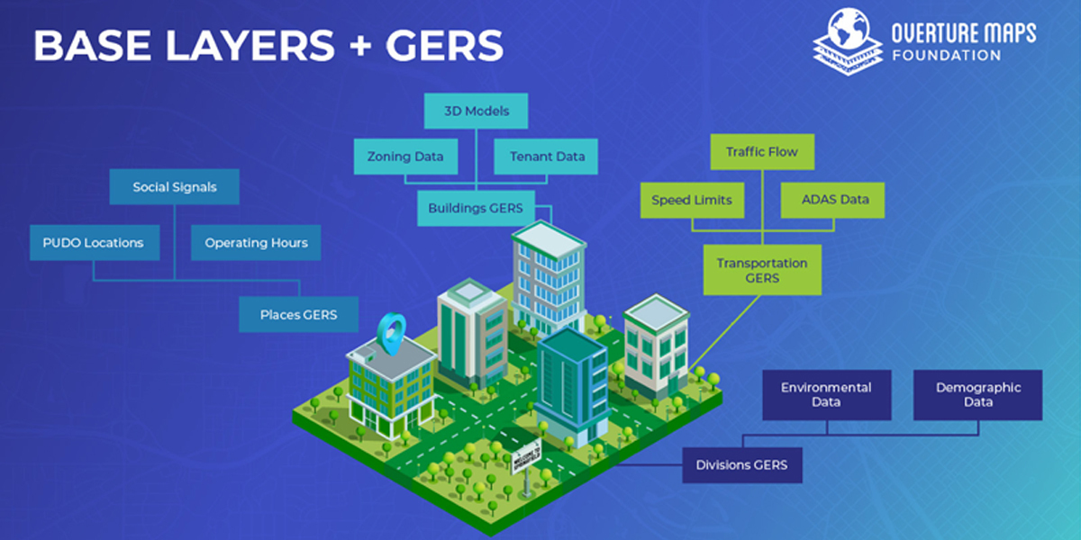
With GERS, data integration becomes dramatically simpler. Instead of relying on fuzzy matching or geospatial overlays, developers join datasets using a shared column of entity IDs. Since the Overture base layer is open, they don’t face onerous licensing restrictions as they might with a proprietary data set. A task that once took weeks takes minutes. Costs drop. The market for geospatial data expands, and everyone is better positioned to invest more in novel and proprietary applications.
Marc Prioleau is Executive Director of the Overture Maps Foundation, a collaborative open-data initiative led by software developers, data experts, cartographic engineers, and product managers. Launched in 2022, its members are working towards a shared vision: to create reliable, user-friendly, and interoperable open map data that supports both current and future map products.
Subscribe to our newsletter
Stay updated on the latest technology, innovation product arrivals and exciting offers to your inbox.
Newsletter

