Share
A new study reveals how the smartphone can help scientists and conservationists understand and balance the needs of wildlife and recreationist
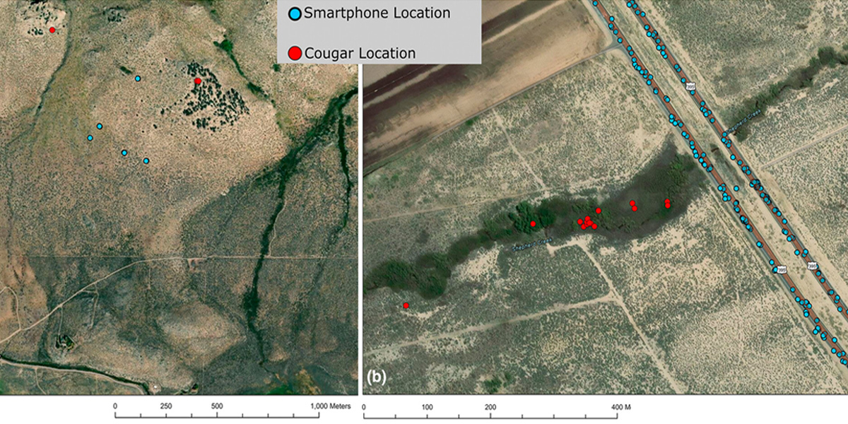
Researchers at Colorado State University and the USDA Forest Service have used anonymized, aggregated GPS data from smartphones to monitor how wildlife reacts to people.
This innovative research highlights the promise of human mobility data, measured via smartphones, as a transformative tool for tracking when and where people move across wild landscapes. Traditional methods like trail counters, trail cameras and satellite images of nighttime light often fall short in capturing human activity and its impacts, especially in remote areas. Human mobility data fills this gap.
The researchers stress that this smartphone data is fully anonymized from applications where users have opted to share their locations, ensuring personal privacy while delivering critical insights for conservation. They show how this technology can prevent and predict human-wildlife conflicts in the study published May 29 in the Journal of Applied Ecology.
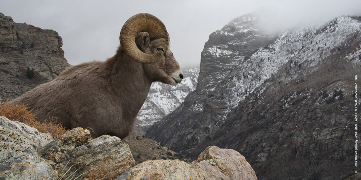
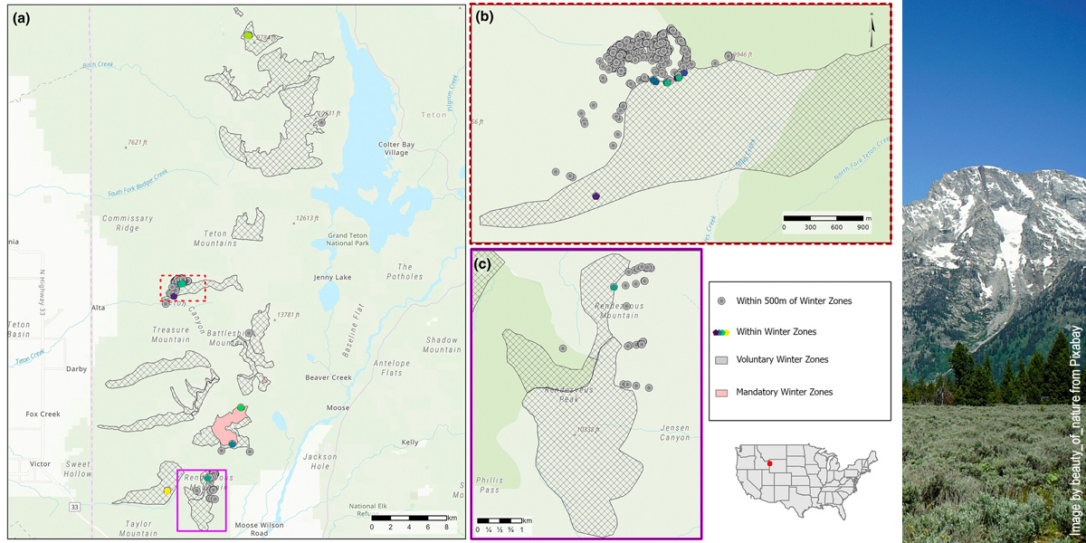
The team combined cougar GPS collar data with human mobility data in California's Sierra Nevada Mountains to pinpoint where people and predators were most likely to cross paths—valuable knowledge for keeping people and big cats safer. In Wyoming's Teton Range, smartphone data revealed where people came closest to the wintering zones of bighorn sheep (pictured in our lead image), helping managers fine-tune seasonal closures or redirect human activity to minimize animal stress during harsh winters.
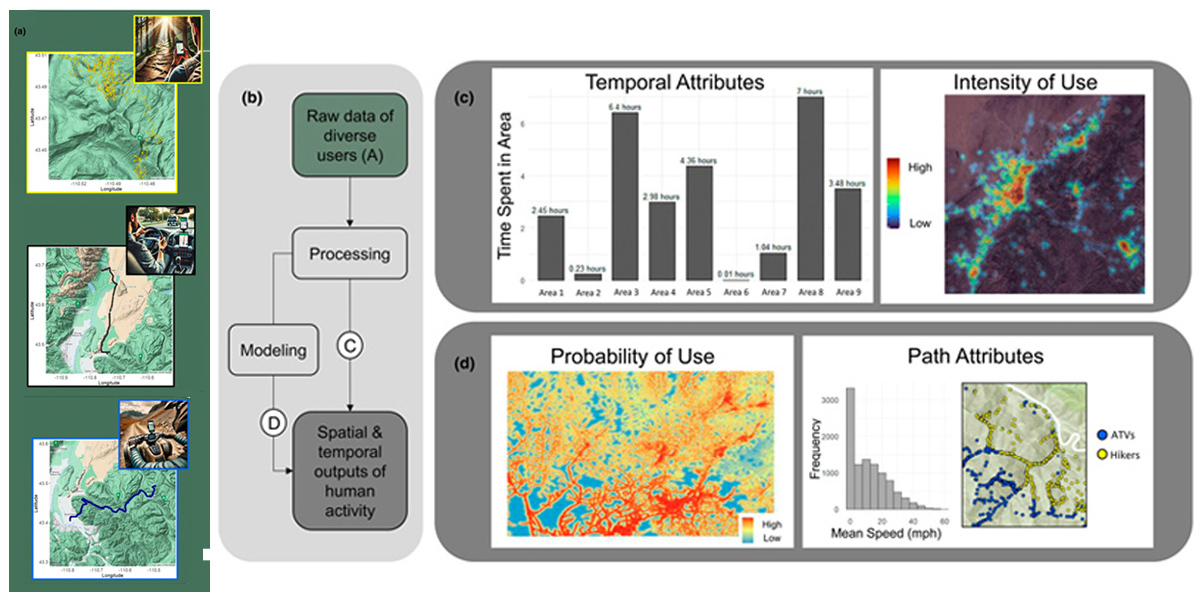
The researchers said using this data along major migration corridors can help with conservation planning. They envision real-time human activity data playing a key role in conservation and land management by helping to better predict how trails, traffic and recreation pressure might shift wildlife behaviour.
"For a long time, we had no easy way to see where people go in wild places," said lead author Heather Abernathy, who conducted the study while she was a CSU postdoctoral fellow at the Rocky Mountain Research Station. "Smartphone data helps us see where human activity might fragment habitat, so we can work to keep landscapes connected—for both people and wildlife."
Recreation is one of the most popular uses of national forests and grasslands and helps build connections between people and nature. Scientists help ensure that people recreating on these lands have the best information to do it responsibly.
"Growing recreational activities are having adverse effects on some species and habitats," said co-author George Wittemyer, a CSU professor of fish, wildlife and conservation biology. "Human mobility data is critical for identifying threats to sensitive species and habitats and enacting management planning to reduce those threats."
The researchers said that this new resource can help to preserve the wild places people love, while ensuring they remain accessible and resilient.
"Human mobility data provides a new lens to see how wild animals respond to differing levels and types of human presence," said co-author and CSU affiliate and alumnus Mark Ditmer from the U.S. Forest Service Rocky Mountain Research Station. "It gives land managers powerful new tools to protect animals and wild spaces while informing conservation and management."
More information: Heather N. Abernathy et al, A case for human mobility data applications in wildlife management, Journal of Applied Ecology (2025). DOI: 10.1111/1365-2664.70073
Journal information: Journal of Applied Ecology
Story Source: Colorado State University
Subscribe to our newsletter
Stay updated on the latest technology, innovation product arrivals and exciting offers to your inbox.
Newsletter

