Share
Fugro’s Marco Filippone explains how hydrography, long regarded as a traditional and highly specialist discipline, is undergoing a quiet but powerful revolution to satisfy the demand for accurate, high resolution hydrospatial data
Advances in uncrewed vessels, underwater robotics, aerial drones, Machine Learning and Artificial Intelligence, supported by cloud-based data platforms, are transforming how we map and understand the ocean. What once took weeks now takes hours. What once required large vessels, and onboard crews can now be achieved safely, remotely and sustainably. And what was once focused on navigational charting now underpins the blue economy.
Global demand for faster, smarter data
Across the world, hydrography is becoming increasingly central to the blue economy. Countries with long coastlines and growing marine sectors are seeking faster, smarter ways to collect and use ocean data. We see strong and growing demand in sectors including offshore energy, port expansion, nature-based infrastructure, and ecosystem restoration.
In Europe, hydrography focuses on environmental monitoring and coastal restoration. Asia emphasises infrastructure, maritime transport, and disaster risk. In the Americas, priorities include navigation safety, habitat mapping, and climate resilience. Each region reflects unique needs, from ecosystem protection to economic development and strategic maritime operations.
A long-standing principle in the field, “collect once, use many times,” still holds value – but is evolving. Today’s clients have an expectation that data can be reused across multiple domains: construction, conservation, planning, and resilience. This shift is redefining how hydrographic services are designed and delivered.
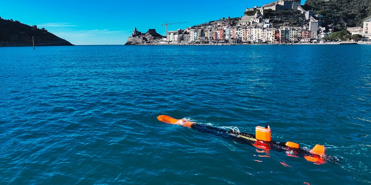
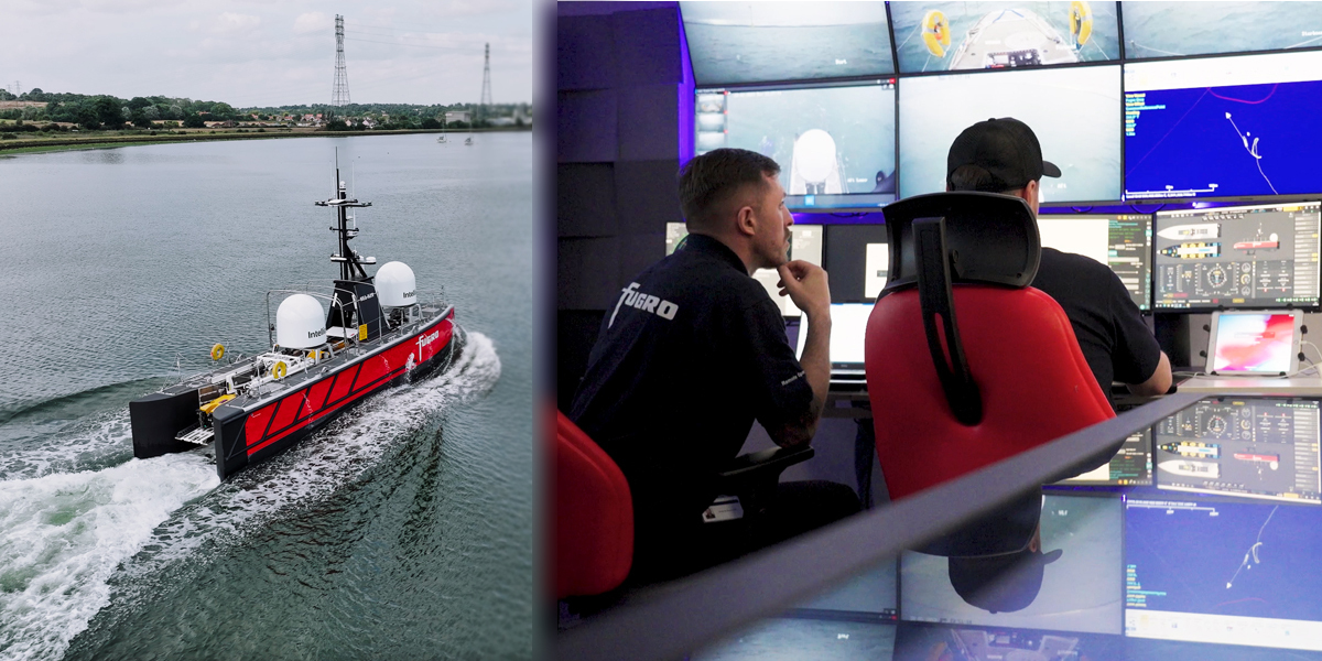
Robotics and remote operations at sea
One of the most significant shifts in hydrographic surveying is the increased deployment of uncrewed and autonomous platforms. These technologies enable remote operations, continuous data acquisition, and a substantial reduction in emissions and safety risks compared to traditional crewed vessels.
A prime example of this in action, this year Fugro is deploying the Blue Eclipse® uncrewed surface vessel (USV) in Norway’s MAREANO programme – one of the world’s largest national seabed mapping initiatives. The vessel will collect high-resolution bathymetry and sub-bottom data over a 675 km² area of the North Sea. Operated entirely from our Remote Operations Centres (ROCs), this project will demonstrate how high-quality data can be gathered safely, efficiently, and sustainably using uncrewed systems.
Looking ahead, development continues across the industry to enhance the endurance, towing capability, and offshore resilience of USVs. These remote platforms are no longer experimental—they are becoming standard tools in modern hydrographic operations, offering more scalable, safer, and lower-carbon alternatives to traditional survey vessels.
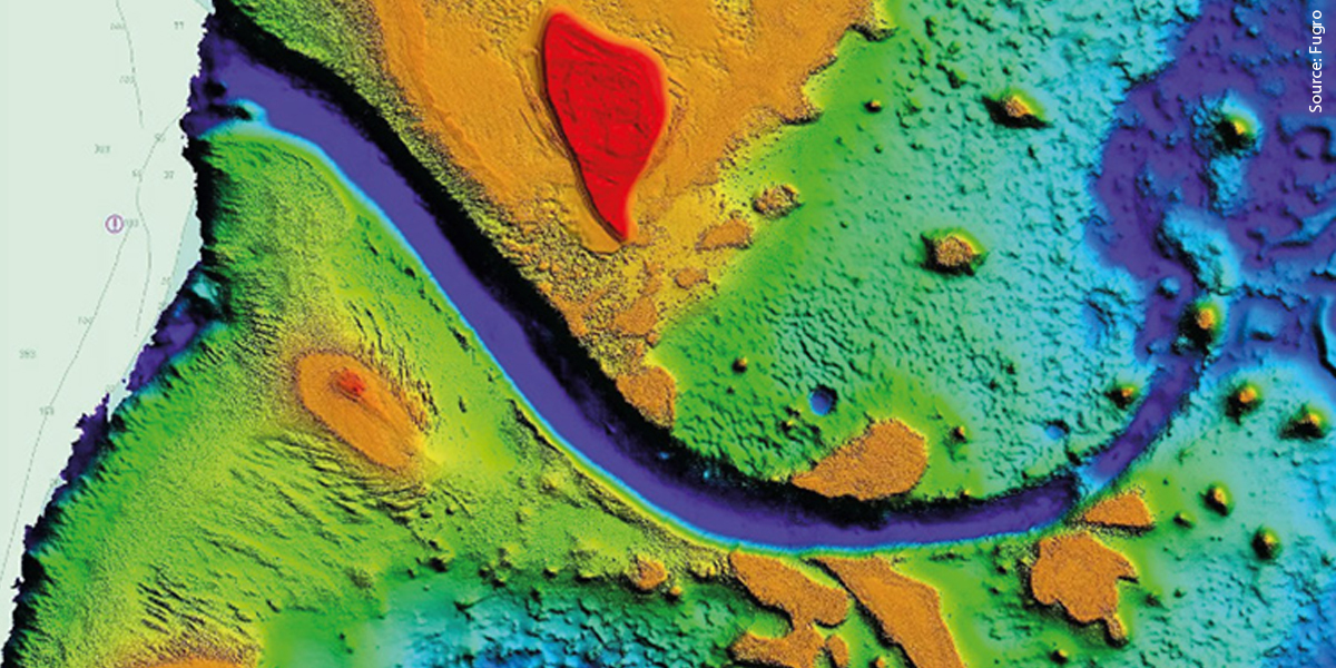
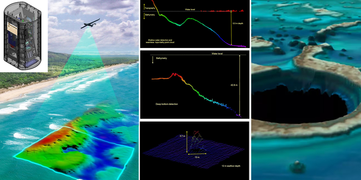
Smarter sensors, richer insights
The hardware and sensors in use with hydrography are also advancing rapidly. Modern systems integrate multibeam echosounders, lidar, sub-bottom profilers, Earth observation satellite platforms, and advanced cameras to capture a multidimensional view of the ocean floor and water column.
These compact, high-performance tools enable us to collect richer, more comprehensive datasets in a single mission. In Italy, for example, we’re currently mapping over 7,500 km of coastline to support ecosystem restoration – including seagrass monitoring for biodiversity and blue carbon strategies. In Saudi Arabia, we are engaged in a couple of projects using airborne bathymetric lidar and marine acoustic sensors to characterise more than 11,000 km² of coastline to International Hydrographic Organisation standards.
Our innovation pipeline includes a drone-deployable, deep-water image-based lidar system– the only commercial solution of its kind. Combined with our patent-pending neural machine learning models, this approach has reduced data processing times from over 40 hours to near-instant. That’s not just a technical gain – it expands the range of projects and application we can serve and accelerates time to insight for our clients.
From raw data to real-time decision making
Collecting high-quality and accurate hydrographic data is only part of the equation. Equally important is the ability to process, interpret, and deliver that data quickly, in a form that supports fast, informed decisions. This is where cloud-native infrastructure and intelligent automation are transforming the data value chain.
For example, our VirGeo® platform serves as the digital backbone of hydrographic workflows. Integrated with our global network of ROCs, it enables the live streaming of large geospatial datasets from offshore assets – including USVs, autonomous underwater vehicles, and airborne sensors – directly to the cloud. The data then undergoes automated quality control, metadata tagging, and preliminary processing, with real-time visibility for both Fugro specialists and clients.
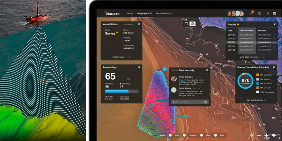
This real-time architecture means survey progress can be tracked visually on a secure dashboard, with data deliverables continuously updated as they are validated. Engineering, environmental, and project teams can access the same live environment, regardless of geography, reducing downtime and enabling proactive decision-making even while surveys are still underway.
Underpinning this workflow are machine learning algorithms designed to automate key aspects of data refinement. For example, AI is used to classify and denoise dense point clouds from multibeam sonar and lidar surveys, identify seabed features, and flag anomalies for human review. These tools significantly accelerate processing times, reduce the manual workload, and help maintain consistency across complex, multi-sensor datasets.
By running data collection, processing, and visualisation in parallel—rather than as separate sequential steps—this approach delivers a more agile, collaborative, and scalable hydrographic service. Ultimately, it shortens the time between survey execution and actionable insight, helping clients respond to evolving site conditions, environmental requirements, or engineering challenges with confidence and speed.
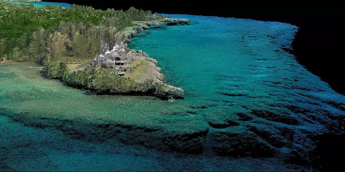
Digital twins of the ocean
With the ability to collect and process data more efficiently, hydrography is increasingly feeding into immersive 3D visualisations and digital twins of the marine environment. These digital replicas combine bathymetry, sensor data, oceanographic models, and infrastructure information into a dynamic, interactive model.
These models are becoming vital tools for developers, planners, and policymakers. They allow users to simulate changes, assess environmental impacts, and coordinate across disciplines in ways that were never possible with static charts.
A profession in transition
As the tools and technologies of hydrography evolve, so does the role of the hydrographer. Certified hydrographers today are no longer just chart makers, they are data specialists, system operators, robotic fleet managers, and analysts.
We are also seeing new skillsets emerge – fluency with cloud platforms, AI workflows, and remote operations. As more of our work moves onshore, into digital control centres and cloud ecosystems, we are opening the profession to a more diverse, globally distributed talent pool.

This evolution is vital, particularly as the industry faces a skills gap in key regions. Building the next generation of hydrographic professionals means fostering both foundational science and technological agility.
Enabling a sustainable blue economy
Hydrography is no longer a niche or background service; it has become a critical enabler of sustainable ocean development. As autonomy, digitisation, and cloud-connected systems redefine how we collect and deliver marine data, hydrography is supporting faster, safer, and more intelligent decision-making across offshore energy, infrastructure, and environmental protection.
The discipline has moved beyond static charts and isolated surveys to become a dynamic, data-rich foundation for design, operations, and long-term stewardship of the ocean. As global demand for marine insight grows, hydrography is not just keeping pace, it is leading the way.
Marco Filippone is Director Ocean Science and Hydrography at Fugro, headquartered in Leidschendam, The Netherlands, and a global provider of equipment, technologies and services that use the power of Geo-data to unlock the secrets of Earth. From surface to subsurface, and from the natural to the built environment.
Subscribe to our newsletter
Stay updated on the latest technology, innovation product arrivals and exciting offers to your inbox.
Newsletter

