New Power BI custom visual for embedding interactive maps
25th February 2020
New Power BI custom visual for embedding interactive mapsAbout Cadcorp
Spatial insight
Cadcorp helps organisations derive meaningful and actionable intelligence from data. We do this with an extensive range of GIS software, spatial data and consultancy services designed to better inform decision-making. With our technical knowledge and expertise, we know how to support our customers in realising the benefits of location information.
https://www.geoconnexion.com/companies/cadcorp
+44 (0)1438 747996
Sterling Court, Norton Road, Stevenage, Hertfordshire, SG1 2JY, UK
1995
Crime Mapping
GIS
Cloud Computing
Interoperability & Open Standards
Location Intelligence
Emergency Services
Property
Central Government
Insurance
Crime Modelling
25th February 2020
New Power BI custom visual for embedding interactive maps
14th February 2020
Cadcorp SIS 9 service release optimises user experience
5th February 2020
Cadcorp launches GIS data management tool
14th January 2020
Welwyn Hatfield Borough Council ‘Think Digital’ with Web GIS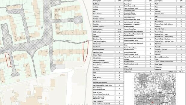
28th October 2019
Setting out weed control tender made easier with geospatial data analysis
10th September 2019
Cadcorp announces 2020 dates for Local Government Conferences
22nd July 2019
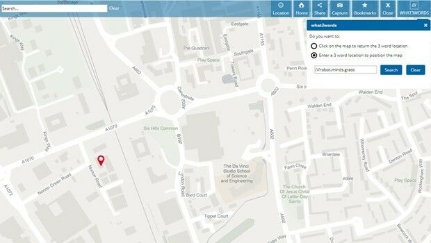
Cadcorp SIS WebMap offers access to what3words addressing

3rd July 2019
Cadcorp introduces Spatial Database Service in G-Cloud 11
9th May 2019
Cadcorp SIS 9 service release extends support for Ordnance Survey data formats

5th March 2019
Cadcorp announces Housing Conference dates
11th February 2019
Newport City Homes migrates to cloud hosted web mapping
6th February 2019
SIS 9 update: Workload Modeller and Risk Modeller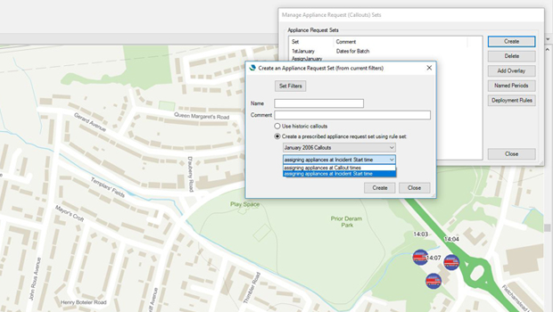
6th February 2019
SIS 9 update: Workload Modeller and Risk Modeller
17th January 2019
Cadcorp announces Local Government Conference dates


20th August 2018
Lincolnshire Fire & Rescue risk-based intelligence calls for Cadcorp SIS
18th July 2018
Cadcorp provides third party quality assurance on workload modelling analysis for Surrey Fire and Re
10th July 2018
Cadcorp releases FindIT to reduce time spent on searches

14th June 2018
Mansfield District Council looks to Cadcorp web mapping to reduce GIS maintenance overheads
24th May 2018
Cadcorp SIS service release supports more Ordnance Survey data formats and comes with added security


31st October 2017
Sefton Council uses GIS to support ‘One Council’ policy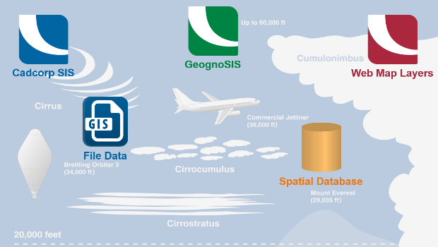
17th October 2017
Cloud migration path for Cadcorp web mapping
29th August 2017
McCarthy & Stone select Cadcorp software for more efficient Workforce Planning
19th July 2017
Wirral Council migrates existing corporate GIS to Cadcorp
22nd June 2017
Cadcorp selected by Wealden District Council via G-Cloud for corporate GIS
2nd May 2017
Cadcorp launches Risk Modeller for Fire & Rescue Services
8th April 2017
Intranet web mapping to South Gloucestershire Council13th March 2017
Cadcorp SIS service release supports latest OS products8th March 2017
Cadcorp Workload Modelling Analysis Service9th January 2017
Arcus Global joins Cadcorp Business Partner Network programme
3rd January 2017
Cadcorp Web Map Tile Service simplifies the deployment of OS data14th December 2016
New Digital Mapping Tool for Citizens Introduced6th December 2016
West Yorkshire Police extend Cadcorp GIS Contract6th September 2016
Cadcorp GIS to put Warrington on the map26th July 2016
Cadcorp and Bramble Hub win contract to provide Bracknell Forest Borough Council with a replacement21st July 2016
Cadcorp selected to provide intranet web mapping capability to Halton Borough Council29th June 2016
Arun District Council grasps opportunities by migrating to Cadcorp GIS
24th June 2016
Arun District Council grasps opportunities by migrating to Cadcorp GIS