
Seabed Geosolutions Mobilises For OBN Survey In West Africa
20th January 2017
Seabed Geosolutions Mobilises For OBN Survey In West Africa20th January 2017
Seabed Geosolutions Mobilises For OBN Survey In West Africa
19th January 2017
Bluesky and Bird.i Join Forces to Widen Access to Aerial Imagery18th January 2017
Esri Releases Advanced Analytics to Increase Retail Sales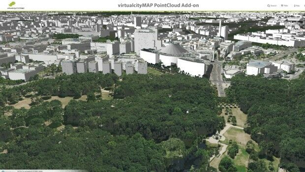
3rd January 2017
Cadcorp Web Map Tile Service simplifies the deployment of OS data29th December 2016
Seven Organizations Receive Cityworks Exemplary User Award27th December 2016
NavInfo, Tencent and GIC to invest in HERE27th December 2016
OGC Calls for Participation in its Indian Interoperability Plugfest19th December 2016
New Esri ArcGIS Release Transforms Spatial Analytics
16th December 2016
virtualcitySYSTEMS simplifies handling of massive geodata29th November 2016
CGG GeoSoftware Releases HampsonRussell 10.229th November 2016
Innovative partnership between Northumbrian Water and 1Spatial25th November 2016
what3words adopted by six national mapping agencies18th November 2016
Investments in open Earth observation data set to grow15th November 2016
Verisk Analytics, Inc., Acquires The GeoInformation Group14th November 2016
John Lewis, Tesco and BMW to speak at Internet of Things World Europe3rd November 2016
Network Rail selects 1Spatial to provide its geospatial technology2nd November 2016
Esri Maps the Way to a More Connected World at IoT West20th October 2016
Anisotropic Inversion for Better Well Placement18th October 2016
East View Nautical Website Now Offering SHOM Charts11th October 2016
LizardTech Releases Latest GeoExpress 9.5.34th October 2016
Applying Big Data to Combat Extreme Weather4th October 2016
New Esri Workbook Teaches Web GIS App-Building Skills3rd October 2016
Arithmetica’s Latest SphereVision 360 Imaging Software Takes an Interactive View29th September 2016
Maxoptra Helps Thornbridge Brewery Keep the Beer Flowing26th September 2016
Esri Chosen by Microsoft as its GIS Service for Enterprise Users21st September 2016
Four Intelligent Transportation Websites For Montérégie’s ITC21st September 2016
Esri Named among the Top 25 Fastest Growing Cloud Companies19th September 2016
Arup and KPF front panel at British Information Modelling Event13th September 2016
The French Ministry of Defense Chooses Global Mapper30th August 2016
Infrastructure Management at the INTERGEO in Hamburg26th August 2016
European Space Imaging & Planetek Italia support earthquake emergency26th August 2016
M6.2 Earthquake - 10km SE of Norcia, Italy - Impact Summary Map18th August 2016
Location Powers Workshop to advance Big Data Geospatial applications15th August 2016
New Esri Training website set to launch in August15th August 2016
4DMapper; the secret behind sharing geodata13th August 2016
GGP Systems partners with Blackpool Council12th August 2016
Global Mapper Chosen for Coastal Mapping Project