
Avineon Announces Head Start Initiative for Esri Utility Network
5th April 2017
Avineon Announces Head Start Initiative for Esri Utility Network5th April 2017
Avineon Announces Head Start Initiative for Esri Utility Network
4th April 2017
Maxoptra Crops Mileage and Delivery Costs for Farm Supplier Zantra3rd April 2017
TCarta Marine to Introduce Gulf of Mexico Streaming Basemap Service
2nd April 2017
Don’t Miss the International IoT Week 2017 in Geneva (June 6-9 2017)30th March 2017
CGG GeoConsulting Awarded Multi-Year Integrated Geoscience Study29th March 2017
Trimble Incorporates Galileo Support in New Version of GNSS Software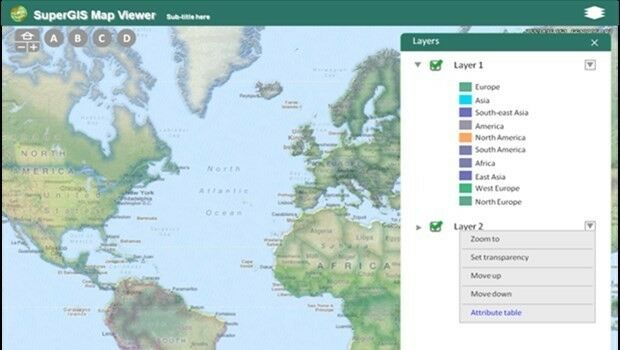
28th March 2017
Towards a More Integrated Web GIS Solution- SuperGIS Server 10
27th March 2017
Bluesky Launches New Online Resource for Geographic Information of Ireland
24th March 2017
Every Emerging Technology. One Digital Transformation Journey

22nd March 2017
3D Repo Brings Cloud Expertise to Government Funded Smart Infrastructure Project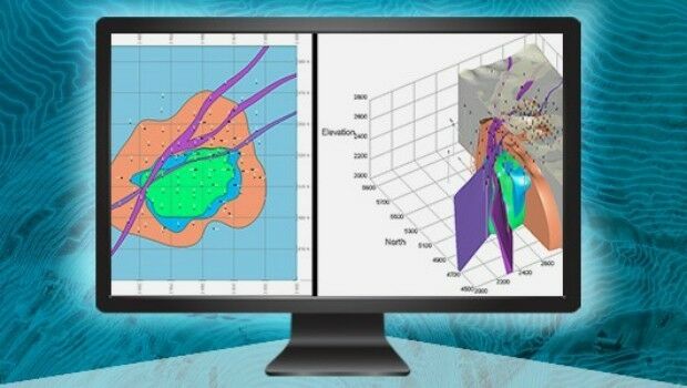
21st March 2017
Esri Teams with IBM to Offer Cutting-Edge Spatial Analytics21st March 2017
The ‘control room of the future’ is here to help police keep you safe
20th March 2017
Maxoptra’s Routing & Scheduling Solution is Purrrrrfect for Natures Menu18th March 2017
Esri Brings The Science of Where to IBM InterConnect 2017
14th March 2017
EU Parliament votes on big data and privacy13th March 2017
Cadcorp SIS service release supports latest OS products10th March 2017
1Spatial Enables Northumbrian Water to Save £8.75m10th March 2017
Oak Ridge National Laboratory Selects Esri
10th March 2017
Esri President Jack Dangermond to Talk at ASPRS IGTF 20179th March 2017
Topcon announces integrated mass data processing software9th March 2017
Moving BI and GIS closer together thanks to GeoQlik
8th March 2017
Disaster Response for the Gulf Oil Spill Webinar7th March 2017
Esri Honors Partners for Exceptional Use of Mapping and Analytics
6th March 2017
EarthSense Scientists Help Students Map Air Pollution for BBC News
1st March 2017
3D Repo wins European funding for cyber security system research
23rd February 2017
Building the IoT: Critical Device-Level Technologies21st February 2017
UAV's help U.S. Military Boost Demand for Satellite Communication20th February 2017
Acquisition Extends Pinkerton’s European Range20th February 2017
Qlucore Projection Score aids better visualization of large data sets
17th February 2017
Biggest Collection of Arctic Elevation Data Yet
16th February 2017
LuxCarta for Global IoT Network Deployment Geodata Requirements
14th February 2017
3D Repo Appoints Andrew Norrie as Commercial Director
13th February 2017
Esri Partners Honored at Esri FedGIS Conference13th February 2017
OGC invites expertise on underground maps and models
7th February 2017
Maxoptra Routing Software Keeps Scot JCB Engineers on Track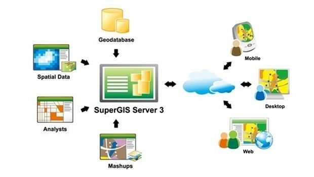
1st February 2017
Location Powers event scaling linked data to big data

26th January 2017
OGC Calls for Participation in Major Innovation Testbed (Testbed 13)
25th January 2017
Abstract Submissions Invited for GIS-Pro 2017 in Jacksonville, Florida
25th January 2017
In focus: The state of sewer management system technology
24th January 2017
Airport GIS | LiDAR, imagery and feature extraction for airport operations
24th January 2017
3D Repo BIM App Helps Crossrail Digitally Manage Assets