Share
Mark Poveda picks out developments from this year’s GEO Business show that could well provide answers.
Can it really be eight years since the inaugural GEO Business event? Our focus then was predominantly on hardware such as 3D Laser Scanners, drones, mobile mapping systems, GNSS and Total Stations. We were also looking at how these could be used to ‘plug the skills gap’, a problem that remains as we struggle to define exactly what we do in a way that will entice the next generation of geospatial professionals.
Eight years on and the GEO Business Show (now running alongside Digital Construction Week) is as useful an indicator of where we are now as it was then. Here are three things that particularly resonated with me:
Improving workflows
Although hardware is still developing, this year’s show also saw many software providers concentrating on improving workflows. While sensors such as mobile mapping systems and 3D Laser Scanners are capable of creating vast data sets, the geospatial professional still encounters a bottleneck in processing, extracting and turning them into intelligent information. It was therefore no surprise to find a number of the presentation stages at Geo Business focusing on Machine Learning and A1 and how predictive algorithms can help. For example, on a recent KOREC mobile mapping project with National Highways, AI was used to identify and classify defects from hundreds of kilometres of roads, thereby reducing an operation that would have taken months down to weeks. This is definitely an area to watch.
Rise of the robot/cobots
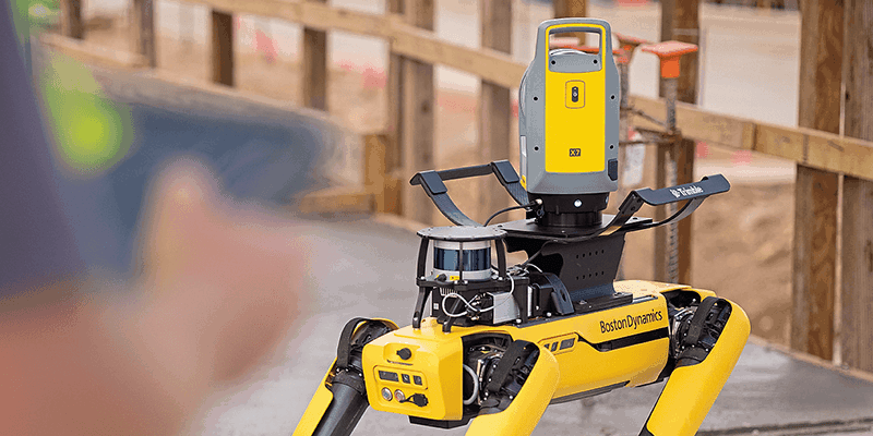
It would be hard to walk around the show and not notice the Boston Dynamics ‘Spot the Dog’ agile robot. While still a very new technology, it was good to see how Spot is being adapted for commercial on-site use, with both Balfour Beatty and BAM Nuttall releasing information on how they have successfully deployed it on projects. Both have been using Spot with a Trimble X7 3D Laser Scanner payload and are great examples of how ‘semi-autonomous’ is now becoming ‘fully autonomous’.
It’s worth noting that Trimble has often referred to Spot as a ‘cobot’ rather than a robot. This emphasises that it’s not there to replace skilled surveyors, but to assist them and free them from mundane or hazardous tasks.
Synergy, diversity and education
While the show gave us with a much-needed opportunity to reconnect with our customers, it’s diverse programme of show floor presentations was also encouraging. These ranged from talks on our industry’s growing inclusivity through to how we can attract the next generation of geospatial professionals.
Finally, it was great to benefit from the synergy that saw GEO Business running alongside Digital Construction Week. Just as mapping and survey became ‘geospatial’, will we now see 3D Laser Scanning, Robots, Mixed Reality and better visualisation tools bringing further crossover with construction?
As I left the show, my overall feeling was that the days of ‘we’ve always done it this way’ are definitely behind us and that the future of geospatial is exciting, evolving and a truly appealing career for the next generation – our challenge is to broadcast that positive message loud and clear.
Mark Poveda is Group Commercial Director of KOREC Group (www. korecgroup.com)


