Share
Neil Slatcher reports on how LiDAR was used in India to map informal settlements in Bengaluru as part of a new phase of urbanisation.
With a population of around 13.2 million, Bengaluru (formerly Bangalore) is the capital of India’s Southern Karnataka state and one of the nation’s largest cities. The centre of India’s high-tech industry and home to hundreds of IT firms, Bengaluru is widely regarded as the ‘Silicon Valley’ of India. The southern Indian tech hub is home to the largest number of high-growth companies in the country, ranking fourth overall among all Asian cities. Of the top 500 companies, 20 are based in Bengaluru – around 4% of the total.
However, despite its high-tech connections and vast number of modern skyscrapers, roughly 16% of Bengaluru’s population lives in informal settlements, with around 500 informal residential buildings recorded in the district.
With new phases of urbanisation and the expansion of the existing city limits on the near horizon, the Bengaluru local government plans to formally declare ownership of the settlements in favour of the residing inhabitants. To achieve this, an official map of the informal areas was needed, documenting each home, including detailed structural measurements such as boundary lines and precise roof heights.
To carry out the groundwork, the Bengaluru government called upon local geospatial mapping service company Nakshatech to survey the area and digitally map the site using the latest simultaneous localisation and mapping (SLAM) technology from GeoSLAM.
Navigating the obstacles
Before scanning could begin, the team fully assessed the task at hand, taking into consideration all the challenges Bengaluru’s informal settlements infrastructure would present.
Lacking formal road requirements and restrictions, the informal settlements make up a complex maze of residential buildings, including many narrow and difficult-to-access lanes, with no clear routes for the Nakshatech team to navigate.
Additionally, with such a high proportion of the city’s population living in the vicinity, these intricate walkways and streets are frequently bustling with people going about their daily activities, creating another disruptive challenge for the surveyors.
In such a taxing environment, static scanning technology, such as traditional tripod-based systems, would be a highly labour-intensive and time-consuming method of collecting data, particularly as the uneven and challenging terrain would present many complications when setting up the device. Due to their cumbersome nature and high footfall of pedestrians moving around the settlements, capturing data using a static scanner wasn’t a feasible solution. The area was registered as a no-fly zone, so UAV-mounted technology was also not a viable option for this project.
To overcome all these challenges, Nakshatech chose to survey the informal settlements using GeoSLAM’s handheld ZEB Horizon scanner. Powered by SLAM technology, the walk-and-scan method of data collection enabled the team to move around the site freely, collecting highly accurate data points as they walked through the complex maze of passageways.
The lightweight, hand-operated device requires only a single user, enabling the team to successfully complete the project in a timely and cost-effective manner, benefiting both Nakshatech and its client.
To obtain all the necessary data, including the precise roof heights of all the informal settlement buildings, the team were also able to mount the ZEB Horizon device onto a lightweight carbon fibre pole, collecting data from an elevated position.
The end result
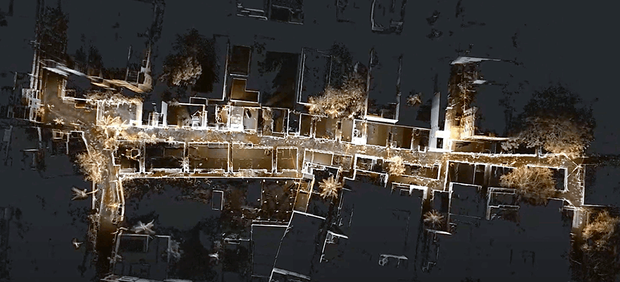
Collecting 300,000 points per second, with an accuracy of up to 6mm and the ability to scan data with a range capacity of 100m, the ZEB Horizon’s versatility was uncompromised by the extensive maze of restrictive passageways and dead ends.
Over the course of three days, the Nakshatech team collected the data for 40-45 different areas of the settlements. Capturing smaller areas of the informal settlements in a single scan ranging from 25-27 minutes, the team mapped larger areas over multiple scans.
Using GeoSLAM Connect software, the team automatically processed the data, minimising the time taken and reducing the background noise.
Processed data was stored in external drives, which was then imported into a photogrammetry grade workstation. Once compiled, the final point clouds were imported into GeoSLAM Draw and Terra Solid, enabling the team to build a 3D environment and extract further information for the final report, including encroaching settlements.
The final data produced a highly accurate, almost identical, digital replica of Bengaluru’s informal settlements, enabling the surveyors to smoothly extract the boundaries and measurements of every individual home using GeoSLAM Draw’s software tools. Nakshatech was able to the city’s government with all the necessary site information needed to progress its urbanisation plans.
By thoroughly assessing the unique challenges of a scan, and selecting the most appropriate tech to overcome the geographical demands, the integral, yet often time-consuming data collection phase of an urbanisation project can be streamlined – the right technology enables more time and resources to be spent on what is most important, improving a city for all who use it.
Dr Neil Slatcher is chief product officer at GeoSLAM (www.geoslam.com)


