Share
In a world fraught with disasters, a geographic approach can make communities more resilient, says Ryan Lanclos.
Respond, recover, repeat. Communities can no longer sustain this cycle in the face of intensifying risks – from violent weather events to social unrest to health crises. Instead, we need to be proactive, designing mitigation strategies that reduce risk and protect our most vulnerable populations.
Many are taking a geographic approach by looking at where the social, economic, and natural systems collide and present the greatest risk, then inviting those most at risk to help highlight potential solutions. The approach uses location intelligence – combining social, economic and environmental data centred on precise locations, delivered by a geographic information system. Leaders use GIS as a tool to share key information among partner agencies; they also use the technology to identify vulnerable communities and to reach out to residents with relevant surveys, dashboards, and online maps. They use these maps to provide the context that is required to drive lasting change for a more resilient future.
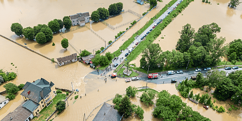
With this understanding, anticipating actions before a threat emerges can mitigate the worst-case scenarios and keep an emergency from turning into a disaster.For instance, firefighters are ensuring they won’t be caught without a source of water by readily sharing data about recent hydrant inspections and locations. Municipal leaders are seeing patterns where devastating flooding is occurring most often and then buying and demolishing structures so rising waters no longer pose a flood risk.
Assessing vulnerabilities to protect the public
A geographic approach empowers leaders to focus on the most vulnerable people and areas. Maps can help planners pinpoint those who lack the financial means to evacuate, need access to transport or simply have nowhere else to go, in an effort to provide more equitable resourcing across the community. Responders can quickly see areas where people rely on a power source that may go out.
In this way, agencies avoid spreading limited resources too thinly or deploying them in the wrong places. Instead, they invest where they can have the greatest impact – to support those who need it the most – to truly change future outcomes.
Ahead of Hurricane Sandy, emergency officials in the US updated storm surge maps, helping to evacuate hundreds of thousands of residents on the East Coast and rescue hundreds in Long Island, New York. The maps directed responders to where the biggest needs would likely be.
Planners can also get ahead of events by using GIS to conduct disaster simulations. With 3D modelling, they can run weather scenarios and calculate possible outcomes, providing an early view of what a future disaster could look like. They can augment digital terrain models to show an area’s population and emergency shelters and determine whether any vulnerable residents would need to be rescued. With this deeper insight and understanding, exercises can test real-world scenarios and ensure response plans are adjusted accordingly to deliver the resilience required in today’s world.
Designing a strategy, then putting it into action
When Hurricane Florence materialised off the coast of North Carolina in the US in 2018, geographic specialists redoubled their preparations. They tested online damage assessment tools used during the previous hurricane. They studied elevation data on maps showing where residents were vulnerable to rising water. Then they planned routes to reach people, if necessary. This geographic approach allowed them to keep watch on water levels in real time.
As rivers swelled, responders were ready. The City of New Bern, North Carolina, dispatched crews to more than 300 water rescues in two days, including in a neighbouring town, avoiding any fatalities. In just seven days, the city knew the cost to rebuild – $100 million.
Staff quickly completed a damage assessment using an online tool that answered the Federal Emergency Management Agency’s questions at the onset. The same assessment was shared and updated in the hurricane aftermath. Without it, they would have had to fill out forms and input information by hand, delaying needed relief. Mere days after a devastating hurricane, the city had gotten back on its feet.
In nearby coastal Florida, cities are taking long-range forecasts and community needs into account as they work to proactively design and fix infrastructure. The effort prioritises challenges at a neighbourhood level for areas with tidal flooding. Leaders now take a holistic, geographic approach to projects such as raising roads, installing riparian landscapes and making stormwater improvements.
Mapping existing utilities, roads and natural features also goes hand in hand with identifying vulnerable populations. In the US state of Indiana’s recent update to its multi-hazard mitigation plan, personnel identified five particularly at-risk groups and the top five counties in jeopardy, ranked by percentage. The groups included low- income earners, older adults, non-English speakers, those who didn’t graduate from high school and those with a disability.
By mapping vulnerable populations, planners can see where people may have difficulty escaping from a disaster or recovering financially and physically.
Communicating risks and resources
In the Philippines, a nation prone to earthquakes, volcano eruptions and typhoons, a major relief agency sought and trained volunteers who lived in or near each of the country’s 42,000 local governments. The agency relied on locals rather than outsiders to document risks that may have otherwise gone unseen. The volunteers saw physical features that might wash away in a flood and knew how many residents may be medically at risk during a hazardous event, collecting this data on mobile devices and sharing the information via smart maps. The relief group could add the locations of community assets such as schools and hospitals, including where doctors and nurses may reside, in case they might be needed. This inclusive process, locally led, created a framework for better community engagement and, ultimately, resilience.
Relief organisations around the world have also worked with residents to help in crafting their own mitigation efforts, including building flood walls or irrigation canals to control rising waters or mapping city-sized refugee settlements so those inhabiting them know where to find resources.
When community members have access to shared authoritative, accurate information in the context of a map that they can relate to, they gain awareness of impending threats and can make better decisions about how to react. Knowing which evacuation zone they’re in or understanding infection rates in their communities amid a pandemic, people can visualise their own risk and choose what to do based on their ability to adapt or cope in the midst of a crisis. They can find relief or shelters through online dashboards and maps and then document their experiences through online surveys that make their voice heard.
There are ways to stay ahead of increasingly complex natural and human- caused catastrophes by understanding the systemic nature of risk and its geographic and social context. GIS can help us better understand, design and proactively build communities that are better prepared for the dangers to come and more resilient in the aftermath of life-threatening events.
Ryan Lanclos is the director of public safety solutions at Esri (www.esri.com)


