Share
With the drone technology market on the up and up, Mark Poveda points to developments that strengthen the business case for surveyors to invest
It’s been a decade since drone technology became commercially viable within our industry. During that time, we’ve seen a massive growth in their adoption as an accepted survey methodology. The events of the last 12 months have further amplified their appeal for those seeking Covid-safe work practices.
It’s predicted that total global shipments of commercial drones will reach 2.4 million by 2023 – increasing at a 66.8% compound annual rate - with the drone service market expected to grow to $63.6 billion by 2025. There has never been a better time to invest in drone technology, and here are my top four business reasons why:
1. Unit costs are down – savings from the off
The reasons for this are many, from improved manufacturing techniques and increased competition to organic growth through innovation and economies of scale. For example, go back five years and an RTK fixed wing drone could set you back around £33k. Today, as the market diversifies, the same platform – as versatile as senseFly’s recently released eBee GEO - retails for as little as £11k. For those new to drone surveying, the pressure of achieving an early ROI by flying the drone every day is greatly reduced, thus minimising the risks associated with a new way of working.
2. Build quality up - maintenance costs down
There’s no doubt that some of the earliest models were innovative but susceptible to the effects of a heavy landing or unexpected gusts of wind. Today’s drones have much greater endurances and can handle wind speeds of up to 46km compared to earlier 20-25km speed
Additionally, many are modular in construction, meaning that damaged parts can usually be replaced by the user, again reducing maintenance costs. Battery life, too, is also up from 15-20 minutes to around 90 minutes, thereby reducing time on-site.
3. Diverse applications – expand your reach
With both fixed wing and rotary drones, the range of applications has grown to include topographical surveys, progress monitoring, quarry surveys, inspection work, volumes, and search and rescue. This has been accompanied by the introduction of cameras dedicated to standard mapping, thermal imaging, increased zoom, wider fields of view and the 3D high quality reconstruction of vertical environments – senseFly’s S.O.D.A. 3D is a great example of what can be achieved with a camera that changes orientation during flight to capture both oblique and nadir images.
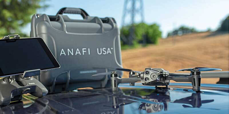
Another example of this diversification is the recent launch of Parrot’s ANAFI USA rotary drone for security and emergency service applications. Operational in just 55 seconds, it is virtually silent, and offers a 32x zoom to capture details as small as one cm from a distance of 50 metres. Larger objects can be viewed in detail from up to 2 km away. It has FLIR thermal cameras to detect vital hotspots and comes with a SD card encryption feature that ensures complete protection of photos and videos if the drone or the SD card is lost. Not least, it comes with a ‘follow’ option for tracking vehicles, etc.
4. Advances in software
Not only is it easier to plan and execute drone missions, but it’s also easier to use the captured imagery as part of an end-to-end solution thanks to office software developments. This increased ability to effectively collect, process, analyse and use is absolutely the way to monetise drone imagery. This has become far easier to do, predominantly through the sharing of data through the cloud. Costs are reduced as there is no longer a need for high-end PCs to handle these formats.
With the need for social distancing and the pressures to reduce our carbon footprint, a particularly useful development has been the ability to stream live data from fixed wing drones via Zoom or Teams. All that’s required is an internet connection. This reduces the number of people on-site and gives office-based colleagues the ability to view the data, and deliver directions and opinions ‘live’.
In conclusion, if you are considering implementing drones into your business, there has never been a better time. We are working in an aggressive and competitive industry and any technology that can contribute to a more effective workflow has to be worth considering. Drones are no longer the future … they are the now!


