Share
In the second of two articles, Haim Srebro looks at how countries around the world determine, monitor and maintain their boundaries – and the vital role geospatial experts play in this
Ensuring the stability of boundaries is of utmost importance in peace keeping throughout the world. Delimitation of the international boundaries and of the internal boundaries of a state, including administrative boundaries and boundaries delimiting land properties and rights of use is very important. The cadastral boundaries are important for ensuring stable legal territorial matters. The law requires fixed unequivocal and unambiguous defining of the boundary lines. Surveyors play a central role in the boundary-making process.
The primary object of achieving stability of international boundaries has been defined by the International Court of Justice. Practical stability of a land boundary between two states can be achieved by jointly maintaining an agreed demarcated and documented boundary. Lack of stability of boundary delimitations has often resulted from unequivocal definitions.
Selection of unclear and unstable features for international boundary delimitation, either artificial man-made changing features such as roads or improper natural geographic features, was common in colonial times. Mountain crests, water sheds, and dynamic physiographic features, such as rivers, lakes and shorelines, were considered as natural choices for boundary delimitation, saving efforts and resources required for field demarcation. However, selecting these natural geographic features caused many problems regarding unclear interpretation or instability of the boundary line.
Roads and buildings disappear or change over time. Boundary lines along mountain crests cross valleys between mountains. High crests may not coincide with the general watershed lines. Valleys are often vaguely defined. Glacier melting exposes different water sheds. Other demarcation problems depend on the dynamic character of the chosen natural geographic features, such as rivers and shorelines that change continuously every second and throughout the year.
Global warming
The origin of many natural geographic feature-based problems results from climate changes and global warming combined with the influence of the population growth all over the world during the last century. Many problems result from artificial man-made works.
Rivers lose water and change, lakes shrink, and in sometimes disappear, and glaciers melt because of global warming and over-exploitation of fresh water. This causes disputes and instability regarding the boundaries.
River boundaries
The cases involving river boundaries are much more diverse and widespread than others. More than one third of the international boundaries throughout the world are river boundaries. Water supply is the most essential natural resource required for human living; therefore, a large part of the global population lives along rivers. The need for water leads to the development of large artificial water projects on rivers; this dramatically changes the natural water flow of the river downstream, as well as its natural balance and behaviour. The water flow of rivers is also used for hydroelectric power stations, constructing dams, reservoirs as well as other works and installations that change the natural behaviour of rivers. These phenomena complicate the maintenance of boundaries in rivers, especially due to the trend found in many boundary agreements whereby the boundary follows continuous gradual natural changes in the river and does not follow artificial changes in the river.
The extent of global warming and the man-made influence on the natural flow and behaviour of rivers all over the world have led to severe problems regarding boundaries in rivers worldwide. This raises questions regarding changes in traditional trends and doctrines (adopted since the Roman times) preferring that the boundary delimitation be stabilized in the river, fixing it by coordinates, and regulating accessibility, as well as rights of use and exploitation, in a separate agreement.
Boundaries in lakes
As a result of global warming and of the over-exploitation of water for growing populations, lakes lose water and partially dry up; for example, Lake Chad lost water due to agricultural irrigation. Another example is the Dead Sea which has lost water because of excessive evaporation through industrial salt pans. In the case of Lake Chad some of the coastal states lost access to its water. In the case of the shrinking Dead Sea Israel and Jordan fixed the coordinates of the boundary line.
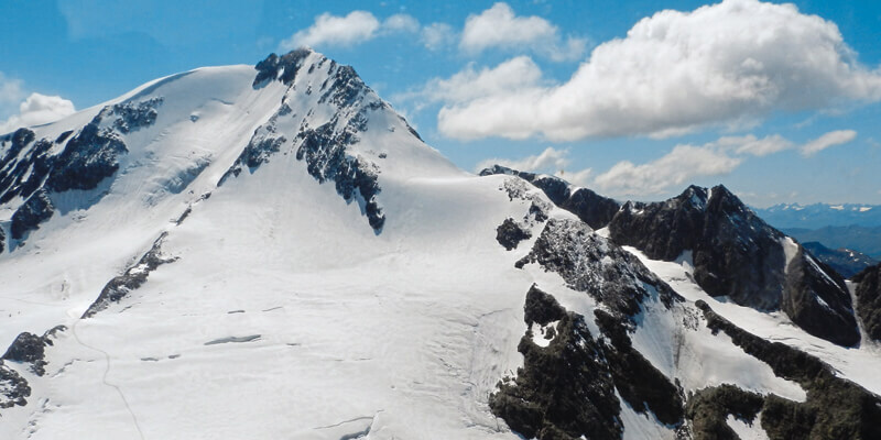
Boundaries on glaciers
Glaciers melt due to global warming; the regions affected include the Alps, Himalaya and the Andes, where boundaries follow icy mountain crests. The watershed along the exposed rocky crests differs from the pre melting icy water shed. Since the boundary line used to be delimited along old icy crests, the neighbouring parties have to define where the new boundary should be located. Italy and its northern neighbours – Austria and Switzerland – have adopted an approach called the moving border, and agreed that the boundary line follows the new location of the watershed.
Boundaries on dynamic land moving due to tectonic activities
Tectonic plates worldwide keep moving, also carrying boundary markers. For example, an Iraq-Kuwait Boundary survey monitored the movement of tens of centimetres after 20 years. This raises the challenge of maintaining the long-term stability of coordinates of international boundary markers, the local reference systems may be inadequate for maintaining the stability of international boundaries. This raises the possibility of connecting boundary reference networks to regional densification of ITRF.
It is worth mentioning that natural phenomena that influence the stability of international boundaries are sometimes interrelated. The movement of tectonic plates along a river may directly influence its course, or indirectly because of possible wall collapses which block its flow, forcing the creation of a bypass. The melting of glaciers, which influences the boundary line along crests, may also influence the boundary line in a lake, by causing the water level to rise and horizontal changes in the coastlines of the lake. In the case of a river and a lake which both serve for boundary delimitation, if the lake partially dries, the river has to find or create a new channel through the dried area in order to get to the lake. This new channel is usually not identical to the old boundary line in the lake.
Haim Srebro is the founder and chair of the FIG sub-committee on international boundary settlement and demarcation


