Share
Network Rail uses 21st Century technology to recreate a Victorian viaduct like never before
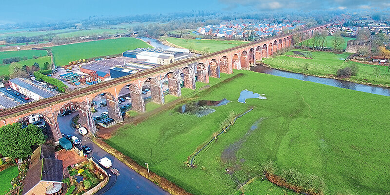
The Whalley viaduct in Lancashire carries the Blackburn to Clitheroe railway line and stretches across the river Calder for a distance of 620m. Opened in 1850, the iconic structure with its 49 red and blue brick arches rises to a height of 21.3m and is known locally as the Whalley Arches.
Traditionally, the surveying and inspection of such structures entailed repetitive measurements and paper-based data entry – a process that was both time consuming, expensive, and required abseiling or scaffolding.
To eliminate the human errors attached to this process, and to improve safety and save on time, Network Rail (https://www.networkrail.co.uk/) has employed terrestrial 3D laser scanning to capture every square inch of the structure. Importantly, trains continued to run as normal over the viaduct during this process. Combined with 3,000 aerial and ground-based photographs of the structure, the laser scans assist in assessing its condition and in prioritising its maintenance.
Digital blueprint
A total of 300 scans were acquired for Network Rail by the Penrith-based 3D scanning specialists, Commendium (https://www.commendium.com/), and turned into a 3D computer model, thereby creating a digital blueprint of the viaduct’s current condition. 3D point clouds were acquired using a Riegl VZ-400 terrestrial laser scanner, a compact, lightweight unit that captures data at a rate of up to 122,000 measurements a second to an accuracy of 5mm at ranges of up to 600m
For Phil James, Network Rail’s North West route director, the 21st century technology gives Whalley viaduct’s engineers a forensic way to plan its essential maintenance. “Great care and attention is going in to make sure our work is right from a heritage perspective. This digital model plays a major role in that as we secure the Grade II listed-structure’s future for passengers, local people and tourists.”
Local stakeholder involvement was essential to the project, says Richard Walters, CEO for Commendium. “At first glance, scanning the Whalley viaduct looks easy. However, the proximity of other interests such as a factory, roads, public footpaths and domestic property has made this a more challenging project. The issue has been finding places to scan from so that we could capture all the necessary walls and features of the viaduct. Therefore, local stakeholder co-operation has been essential and, frankly, without their enthusiastic help, the job would have been very much harder.”
Preserving for future generations
Ongoing work on the structure includes brickwork repairs, the removal of vegetation and repairing the damage caused by plants and weeds, viaduct strengthening work, and work to stop the viaduct’s bases – or piers – suffering from river erosion.
Nigel Evans, deputy speaker of the House of Commons and Ribble Valley MP, added: “I know many people travel long distances to see the iconic Whalley railway viaduct and it is so important that it is preserved for future generations. It is through projects like this one that its future can be ensured and I am pleased to see that Network Rail is undertaking the necessary work to achieve this.”
The information and imagery included in this article are reproduced here courtesy of Network Rail which owns, operates and maintains Britain’s railway infrastructure; including 20,000 miles of track, as well as 30,000 bridges, tunnels and viaducts.


