Share
The OGC is aiming to have actionable information available within the ‘golden hour’ of a disaster striking. Josh Lieberman reports on the organisation’s Disaster Pilot 2021 and a recent showcase of the prototypes designed to meet that objective

OGC recently wrapped up the Disaster Pilot 2021 with a three-hour online demonstration event that showcased the prototypes developed during the pilot. Running over the course of eight months, the Disaster Pilot ’21 built upon the work of the 2019 Disaster Pilot and other OGC Innovation Initiatives to improve the ability of decision- makers and responders to quickly discover, access, share and act upon location-based and earth observation (EO) information in support of disaster awareness, preparedness and response, as well as multi-hazard risk assessment. Such improvements not only impact decision-making, but save lives.
The pilot demonstrated how to achieve these improvements through its development of standards-based prototypes and by publishing two freely available “user readiness” guides – one for data providers and one for data users – that help stakeholders be “ready to roll” with the right information at the right time in the right place whenever disaster strikes.
The full ambition of OGC’s disaster management initiatives is to have actionable information available within the ‘golden hour’ of the disaster – the first 60 minutes – which is the key time for affecting the outcomes of the overall response. To deliver on such an ambition requires the use of multiple technologies underpinned by pre-agreed standards to establish a robust, flexible computing ecosystem for rapid deployment when a disaster occurs.
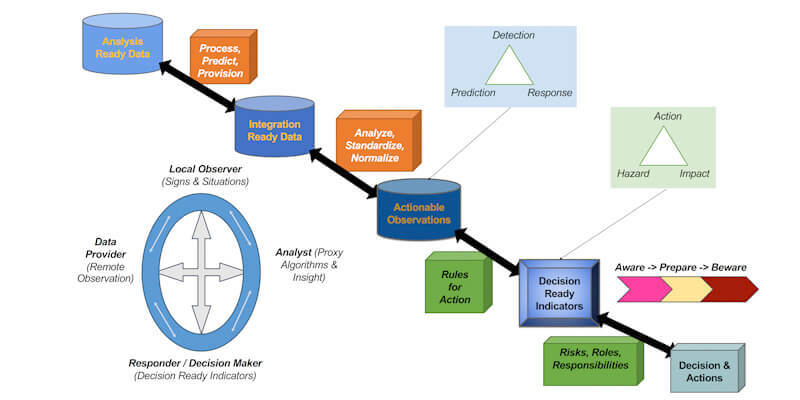
Pilot participants developed an operational prototype that demonstrated how practitioners could find disaster-relevant EO and other data, process it to develop analysis ready datasets (ARD), share those datasets, interpret them to create decision ready indicators (DRI) supporting decisions and actions, and then leverage familiar tools to visualise, communicate, and collaborate with everyone involved in the response.
By developing a functional prototype of this disaster awareness ecosystem and applying it in the context of three hazards (flooding, landslides and a pandemic) in four regions in three different countries (Peru, Canada, USA), the pilot participants were able to better understand what is possible, where the challenges lie and how to transform their vision into reality.
Disaster readiness guides
Time is of the essence during a disaster and too much time is currently spent wrangling data formats, negotiating licence agreements, finding computing capacity and getting up to speed on geospatial systems, analysis, data aggregation and transformation methods, visualisation techniques, interpretive authority and so on. All of this impedes the timeliness – and the impact – of geospatial data.
A clear outcome of the pilot was that, if the full vision of timeliness is to be achieved, a global observational information ecosystem needs to be operating with practitioners ready and trained to make use of it. This readiness means having in place the needed data handling capacities and agreements to enable cooperation between data providers, preparers, policy makers and users. Binary agreements between individual data providers and users are not sufficient to provide the necessary agility, nor can a single solution fill all needs. What’s required is a set of agreed operating approaches and standards such that, for example, the data providers know the format in which they need to provide the data and users can immediately integrate that data within the system that works best for them. This combination of standards and readiness will be what delivers information smoothly and rapidly to enable timely, informed decisions and actions.
With this in mind, the two freely available user/provider ‘readiness guides’ were developed to outline ways that each end of the disaster data pipeline can ensure – before a disaster strikes – that the right data can be collected, integrated, analysed, and delivered where and when it’s most valuable. The guides have been published as living documents: feedback from stakeholders in disaster management is actively sought, and the guides will be updated as feedback is received, best practices evolve, technology improves, and as outcomes from future disaster pilots and other OGC Innovation Initiatives add to our collective body of disaster management knowledge.
Reusable recipes for decision-making
However, timely data may still not be the right information to guide disaster management decisions and actions. The Disaster Pilot also focused on development of “recipes” for decision-ready indicators that transform geospatial observations, such as SAR measurements, into specific, localised, time- specific guidance, such as “evacuate this way” or “prepare to evacuate” or “sit tight but keep informed”. Through collaboration between data providers and on-the-ground responders, these recipes describe: what analysis ready data is needed in a given disaster scenario; how to integrate, process, and transform it into decision ready information; and how decision makers and responders can make use of the results to inform their actions and optimise their effectiveness.

Although recipes and indicators vary from disaster to disaster, they can be set up within a structure that includes their applicability timescale (short-term predictions and impacts to medium- and long-term predictions) and type/geospatial extent of the disaster. They can then be combined as needed when disasters ‘cascade’ into each other (for example when a flood triggers a landslide and/or a disease outbreak).
A range of tools can be used to implement these recipes, which are readily interchangeable and reusable in different contexts, so as to maximise flexibility and minimise single points of failure. Two approaches tested during the pilot were the use of open-source web-based scripted tools such as Jupyter Notebooks, and model-based spatial extract, transform, and load tools to support data integration and automation.
Ongoing development
The two OGC Disaster Pilots so far are just the start of ongoing work from OGC concerning disaster management. The next Disaster Pilot will begin this year, and will build upon the work of the previous two by covering more hazard-types and developing better, more accessible tools with a focus on service oriented architecture and analysis ready computing. Another goal will be to improve information outcomes by supporting first responders with technologies and information that enhance the mission capabilities they already employ.
Josh Lieberman is director, innovation program, at the OGC (www.ogc.org)
FURTHER INFORMATION
For more information on the OGC Disaster Pilot 2021, including engineering reports, the full recording of the demonstration event, and how to participate in the 2022 Disaster Pilot, visit ogc.org/ disasterpilot. To read and provide feedback on the readiness guides, visit readiness.disasters.ogc.org.


