Share
Using specialised handheld hardware for site scanning with RTK accuracy helped capture, process and vectorise a historic stone bridge in Turkey. Eloise Mitchell reports.
Modern surveyors need to balance multiple factors in choosing their equipment. These include considering whether to focus on portable tools or heavier-duty kits and the trade-offs between expensive gear and cheaper alternatives. How can they decide where accuracy needs to compromise with affordability? Both photogrammetry and LiDAR can provide solutions with high degrees of accuracy but can have extreme ranges in price. The deciding factors are usually price, accuracy and the scope of a surveyor’s typical project.
This ‘balancing act’ is driving the development of new surveying toolkits and workflows, such as the viDoc RTK rover, a mobile device case that attaches to select iOS and Android devices. It gathers RTK during data collection with the terrestrial scanning app PIX4Dcatch. Connected via Bluetooth, the software and hardware gather LiDAR and photogrammetry data. The RTK case connects to local NTRIP networks to guarantee its accuracy whilst pairing with the mobile device using Bluetooth. This transforms a phone or tablet into a professional surveying tool.
The combination of LiDAR and photogrammetry starts during data collection. PIX4Dcatch uses LiDAR feedback from select iOS devices or time-of-flight sensors on certain Android models to create a live preview of a 3D reconstruction while you use it to gather data around a site. The LiDAR helps prevent any data from being missed during a site scan. Meanwhile, the app is collecting imagery for photogrammetry that can be processed alongside the LiDAR and RTK data.
After a terrestrial scan is finished, the dataset can be exported for processing with specialised software, including PIX4Dmatic. This desktop processing software is where photogrammetry and LiDAR can then be combined. Photogrammetry and LiDAR create dense and depth point clouds respectively. With PIX4Dmatic, either dataset can be processed or they can be merged to create a fused point cloud. That final point cloud takes advantage of both forms of technology – photogrammetry can capture a wider scene with a high degree of detail while LiDAR fills in any gaps that photogrammetry cannot capture as well, such as areas in shadow. The entire workflow turns a mobile device into a professional surveying tool that can be carried in a large pocket or backpack.
Testing it in the field
The viDoc was launched in 2021 and has been authorised in multiple regions worldwide. One instance of it being used was in Turkey by Atay Engineering. Atay is a company based in Ankara that uses photogrammetry and remote sensing for terrestrial and aerial surveys. It has worked in this field since 1995. Atay’s expertise means that it is trusted by clients across Turkey, including municipal experts in Ankara.
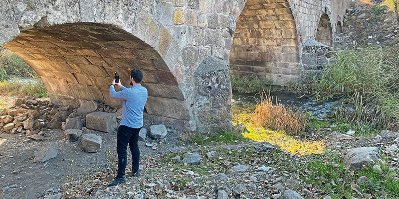
Atay was contracted to survey an old bridge on the outskirts of the city as part of wider efforts to restore historic elements that needed maintenance work. The old bridge was made of a mix of cement and large rocks to create the overall structure.
Atay set out for the bridge with a viDoc RTK rover and an iPhone 12 Pro. The plan was to scan it from all angles to create a comprehensive 3D model that could be shared with municipal authorities.
Once on-site, Atay decided to gather images using three data collection paths: either side of the bridges and then over the top. After this site assessment was finished, an engineer connected the viDoc to a local NTRIP network. This would guarantee the RTK accuracy for their survey.
As the engineer collected the data, they used the live preview feature to assess the completion of the model. This showed the engineer a rapidly generated version of the bridge that helped them determine how much data had been collected and what had been missed or needed to be revisited with the scan. To reach parts of the bridge that were trickier, the engineer attached the iPhone to a surveyor’s rod.
The total site scan took just 45 minutes to complete. With the LiDAR feedback and preview, the engineer knew they had enough data to create a final point cloud that would have no gaps in the 3D reconstruction.
Processing a merged dataset
Once Atay’s engineer had finished collecting data, they returned to the office. There they transferred the dataset to PIX4Dmatic for processing. When the dataset is imported to PIX4Dmatic, it is processed to create a point cloud. Surveyors then have the option of using a depth point cloud (from the LiDAR data), a dense point cloud (from the photogrammetry imagery), or a fused point cloud.
The fused point cloud is especially useful as it solves the issue of GPS and IMU drift on mobile devices. This is caused by the real-time position/orientation estimation of the ARKit of a mobile device, which does not always match its actual position. LiDAR scans could potentially be misaligned as a result of this. PIX4Dmatic computes more accurate geolocation and orientation data in photogrammetric processing. That accurate data is then used to align the LiDAR scans and ensure the accuracy of the LiDAR results. Similarly, if the photogrammetry processing needs to be improved, a user can add manual tie points to enforce the correct alignment between photogrammetry and LiDAR data.
After both point clouds are completed, the option to merge them means that they can be combined without issue. The combined datasets will allow for a more comprehensive final 3D output, as gaps left by LiDAR can be supplemented with photogrammetry data or vice versa. This is especially useful for dealing with situations where there is distortion from shadows or changing light.
After processing the point cloud, the dataset was transferred to PIX4Dsurvey to finalise the digital surveying workflow. This would prepare the dataset for conversion into CAD-ready files. For this dataset, Atay wanted to vectorise the point cloud and identify any features such as drainage or curbs that would need to be taken into account during restoration. With automated identification, Atay could easily create a final report for the municipal authorities that included annotations of maintenance needs as well as current infrastructure that has already been installed.
The future of a new surveying toolkit
Surveyors around the world are taking advantage of the workflow offered by the viDoc and Pix4D software. Its certification by Bureau Veritas in 2022 was an external confirmation of the centimetre accuracy that is so crucial to surveying. As portable LiDAR and GNSS equipment go, the viDoc has a lower price point and takes advantage of the staggering developments in technology for mobile devices. The joint LiDAR, photogrammetry and RTK workflow has meant that terrestrial site scanning with a mobile device can render highly accurate results that mitigate and stop any locational errors from the mobile device’s GPS. The option to combine different types of data is an exciting new development that will unlock new workflows for professional surveyors.
Eloise Mitchell is a content marketing specialist at Pix4D (www.pix4d.com)


