Share
Vicki Speed looks at how custodians of historic sites and structures are turning to reality capture and digital workflows to document, protect and maintain Britain’s cultural heritage
Historic buildings, archaeological sites and landmarks are continually at risk of damage from environmental, human or natural forces. The recent earthquakes in Turkey, the wars in Iraq and Syria, the fire at the Notre Dame Cathedral in Paris and the Taliban’s wilful destruction of the 6th-century Buddhas of Bamiyan are just a few examples of the threats to historic sites from external forces. Reality capture technology is helping preserve, protect and, in some cases, rebuild these impressive works of art and history. That same technology is at work on cultural heritage sites across the British Isles.
Comprehensive and accurate
Safeguarding historically significant buildings, structures, objects and sites requires the ability to assess, compare and repair conditions without causing more wear or worsening the damage. These assessments range from evaluating structural integrity to studying long-term environmental effects. It’s imperative that site data is comprehensive and accurate and is collected without needing to return. Laser scanning is uniquely equipped to satisfy all of these conditions.
Today’s reality capture technology is able to collect details down to a millimetre very quickly, while advanced software facilitates fast, accurate data post-processing. It also supports transitioning massive point cloud datasets into manageable 3D models that can be used for analysis, repair planning, future reference – and even virtual tours for the public.
As part of this action to save the past, Historic England is a non-departmental body of the British government tasked with protecting the historic environment of England. It has long recommended the use of laser scanning and digital workflows for historic sites and also provides technical guidance and advice about the technology for the preservation of historic places.With a nod to future best practices, it even includes reference to surveying and imaging technologies that use pedestrian- and vehicle-based mobile mapping systems.
Taking stock to guide the future
Preservationists and surveyors are putting scanning technology to work on many heritage sites around the country as a precaution against natural or human-caused disasters. These models are also integral to virtual tours of heritage sites, helping showcase history to a new generation.
With cultural asset scanning projects underway across the UK, the examples on the next two pages demonstrate how increasingly automated and digital workflows are helping record history from hundreds or thousands of years in the past and preserving it for the future.
- https://historicengland.org.uk/ ;
- https://historicengland.org.uk/advice/technical-advice/recording-heritage/
Vicki Speed is a freelance writer who has specialised in the AEC space for over 25 years. She has an interest in and passion for all things about the industry from contracts and risk management to people, processes, equipment and, especially, technology.
Steadfast and true
The flexibility of laser scanning is ideal for historic infrastructure. The cast-iron arch Mythe Bridge on the A438 near Tewksbury in Gloucestershire is a prime example. Completed in 1826, the bridge is a Grade II* site on the National Heritage List for England, meaning it is a particularly important structure of more than special interest, warranting every preservation effort.
The bridge has undergone several strengthening efforts over the years, but those records are largely paper-based. The transportation agency responsible for maintenance sought a 3D ground-based and aerial reality capture survey to more accurately assess the bridge’s structural integrity. For the ground survey, the geospatial team used the Trimble X7 laser scanner to gather the data.
The survey team from Scan to Plan then conducted more than 40 setups in a single day, with each setup and scan taking around 5-7 minutes to capture a point cloud with 3mm accuracy. Scans were undertaken on every other row of the bridge with the team working across the six girders on each of the five bays.
In this case, the self-levelling feature of the X7 was essential to the quick setup speed and survey-grade accuracy. The scanner achieves survey-grade tilt compensation if the instrument is set up within a working range up to 10° from either side of its vertical axis for upright and upside-down scans. An aerial survey was then conducted to fill in any gaps in the point cloud, where there was no physical access.
The survey team and the customer were especially pleased with the fast, accurate deliverable, which was pushed to AutoCAD to create 2D line drawings.
New perspectives
Laser scanning is also manoeuvrable. A heritage survey team used a reality capture scanner to perform a full building survey prior to generating an Autodesk Revit 3D model of St Peter’s Church in Bywell, Northumberland.
This Anglo-Saxon building dates back to at least the 9th century when the small village and parish was one of the most important settlements in Northumbria.
On a snowy day, the survey team from AMR Geomatics (Northern) Ltd conducted a topographic survey using the X7 of the internal and external structure, including the bell tower. Once in the tower, the scanner was carried up a ladder and positioned (with help from the built-in levelling technology) in a confined space on steel beams.
The data was registered and checked onsite with Trimble Perspective and then, back in the office, transformed into a 3D Revit model.
Structurally sound
One of the most beneficial aspects of reality capture and new digital workflows is the ability to proactively analyse structural defects before irreparable damage occurs without further damaging already fragile sites.
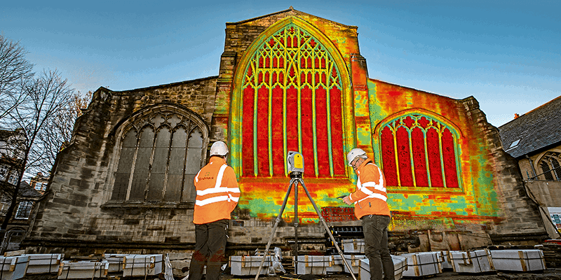
The preservation of the spectacular English Gothic Newcastle Cathedral in Newcastle upon Tyne is one example. This cathedral reflects master building proficiency in the Middle Ages. The current stone structure was completed in the 14th century, and its uniquely recognisable 60-metre-high crown lantern spire was constructed about 100 years later.
Two years ago, the Diocese of Newcastle sought to restore deteriorating stonework that was due to pollution. The church also needed dimensional marks of the groundworks to place a new outdoor terrace in the cathedral churchyard.
A two-person survey team from Gridmark Survey spent three days on the site scanning the cathedral and grounds using a Trimble® X7 3D scanning system (pictured in our lead image on page 36). They took 104 individual laser scans, capturing 3.7 billion measurable points in the process. Saving valuable time, each scan was automatically calibrated (no targets or user interaction to measure primary axis errors) within the system.
Another benefit of the X7 is the self-levelling capabilities, which reduce the amount of time surveyors must spend on-site to assure accuracy. The system incorporates an automatic survey-grade level compensation feature for both upright and upside-down orientations, facilitating a survey grade accuracy of <3” = 0.3mm at 20m.
The X7 is fully integrated with Trimble Perspective, a point cloud processing and analysis software specifically designed for in-field control, measurement and registration. While in the field, the software helped ensure point cloud registration to ground control points. Scans were automatically linked to the project coordinate system within Trimble Perspective, with in-field registration being particularly beneficial on sites where accessibility is difficult. Another advantage of this technology is that the surveyors did not have to place targets to register the scans, further minimising physical activities on already sensitive sites.
With scans and images captured, fully registered, refined and controlled, the data was ready for export in a variety of established data formats in various software suites.
In this case, the survey team automatically registered point cloud data from laser scanners and then created a scaled 3D digital model of the cathedral using Trimble RealWorks™ software. The requested deliverable was a 3D point cloud of the combined 3D laser scan and drone data, along with RCS files, which were easily processed in RealWorks in preparation for use in AutoCAD and the creation of 2D line drawings.
The value of the model was immediately evident. The restoration team could see quite easily where pollution had eaten away much of the stonework and could begin to plan restoration actions.
Conventional methods would have required a stonemason to physically evaluate the structure with handheld tools, scaffolding and considerable labour—a task that could take weeks. The survey team believes that the digital data gathering, modelling and analysis workflow will revolutionise how the stonework is inspected and measured forever.


