Share
As the build phase of the National Underground Asset Register (NUAR) celebrates its first anniversary, the Geospatial Commission has set out what has been achieved to date.
Following a series of pilot projects, the Geospatial Commission and industry partners have been engaged over the past year in developing the new NUAR platform – one that will improve digital data sharing between utility asset owners and those who plan and carry out excavations. Once complete, the new platform will provide them for the first time with digitised underground asset information across England, Wales and Northern Ireland in one place. Scheduled for nation-wide rollout in 2024/2025, the NUAR promises to improve safety by reducing inadvertent ‘strikes’ on subsurface pipes and cables and cutting delays to traffic caused by roadworks.
Engagement
October of this year saw the Geospatial Commission publishing a 15-page Project Update to set out progress achieved over the previous year. In summary, this includes:
- Holding security workshops to share and refine requirements, ensuring that security- mindedness remains a central consideration.
- Engaging with other international underground asset initiatives to learn and share best practice. This has helped development of the new Model for Underground Data Definition and Integration (MUDDI model) ... one that will standardise the way geospatial data about underground infrastructure is presented.
- Publication of the NUAR economic case and regular updates on progress. Additionally, the Commission has attended conferences, held webinars and hosted round tables to discuss in detail the benefits the service will bring to the underground asset industry.
- Liaising with asset owners in the three regions that are to go live first in 2023: North East England, Wales and London. In these regions, community user groups comprising some 500 stakeholders have been created to encourage input and the exchange of ideas at all stages of development.
Legal frameworks
The user groups have held crucial discussions on the two-part legal framework that governs data sharing within the platform, i.e.:
- The signing-up of asset owners to a Data Exploration Agreement (DEA). This allows NUAR data experts to map an asset owner’s data to the NUAR data model and provide feedback. Through this process, a Data Ingestion Specification (DIS) is created which sets out how data will be provided and transformed on an ongoing basis.
- The entering of asset owners into a Data Distribution Agreement (DDA) with the Cabinet Office. This sets out the terms under which their data will be shared with others.
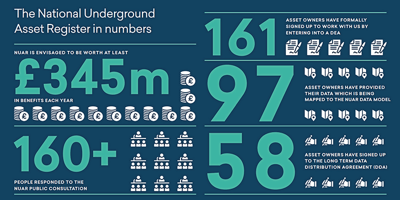
To this end, the Commission has engaged with more than 250 asset owners in the initial rollout regions, as well as some asset owners who operate in other regions. To date 161 asset owners have formally entered into a DEA. 97 of them have provided data that the NUAR data team has mapped or is currently mapping to the NUAR data model. In addition, Data Ingestion Specifications have been agreed with 49 of those organisations.
58 asset owners have so far signed-up to the long-term DDA which allows their data to be shared with others via NUAR. These agreements have been signed with asset owners of various sizes from across all target sectors, including all major utility providers in North East England and the majority of those in London.
For the full Project Update, please log on to https://assets.publishing.service.gov.uk/government/uploads/system/uploads/ attachment_data/file/1109507/NUAR_ Project_Update_October_2022.pdf


